Tropical Storm Warning for NE NJ: Henri rain, wind, surge Q&A
UPDATE... This article is outdated...
For the latest storm forecast information, please refer to my newest weather blog post.
UPDATE as of 11 a.m. Saturday...
With maximum sustained winds of 75 mph, Henri is now officially a category one hurricane.
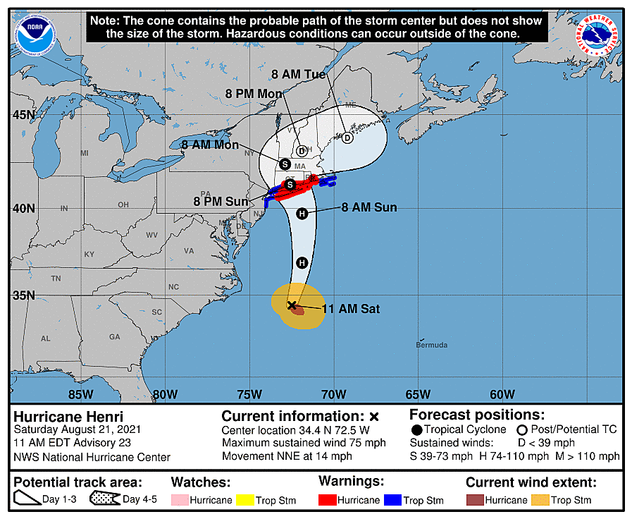
There is no change to Hurricane Henri's anticipated track, timeline, or impacts for New Jersey. We still have a Tropical Storm Warning for six counties from Bergen to Monmouth.
(Keep reading for my comprehensive forecast from earlier this morning.)
ORIGINAL POST from 9:19 a.m. Saturday...
What's the latest?
As of 8 a.m. Saturday, Tropical Storm Henri is centered about 400 miles south-southeast of Cape May, N.J. The storm is moving toward the north-northeast at 12 mph. Maximum sustained winds are estimated at 70 mph - a strong tropical storm. Henri will probably be upgraded to a hurricane in the 11 a.m. or 2 p.m. update.
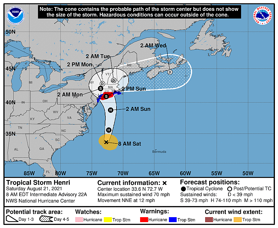
Over the past 24 hours, as Henri made its turn to the north, we have seen a definite nudge of the forecast track toward the west. That's closer to New Jersey. Models are coming into pretty good agreement on the idea of a Long Island landfall, rather than Rhode Island or Cape Cod. And the idea of a sharp turn into the Jersey Shore also looks unlikely, I'm happy to say.

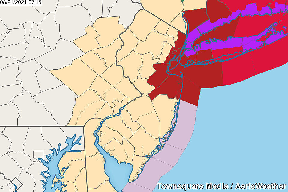
Still, we are going to feel Henri's impacts here in New Jersey - calendar day Sunday will be the nasty day. A Tropical Storm Warning is now in effect for all or part of 6 NJ counties: Monmouth, Middlesex, eastern Union, eastern Essex, Hudson, and eastern Bergen. That means tropical storm force winds (39+ mph) are possible within 24 hours.
There are still some questions about the strength and size of Henri at landfall, just how close it will pass to New Jersey, and whether it turns and stalls over the Hudson Valley into Monday.
Let's run through the latest Henri forecast, Q&A style.

Who's getting hit the worst?
The strongest part of a hurricane, based on its counter-clockwise circulation, is in the front-right quadrant of the storm. Also, the closer you are to the center of the storm (the "eye"), the higher the wind speed, rainfall intensity, and tornado risk.
So that is the other side of the storm from New Jersey. Central and eastern Long Island, southeastern Connecticut, Rhode Island, and even part of southern Massachusetts will feel Henri's brunt this weekend.
6+ inches of rain, 75+ mph hurricane force winds, and up to 5 feet of storm surge? Yikes.
Now there is a chance the storm wiggles even closer to New Jersey as it approaches. There is an equal chance it wobbles farther away. In either case, we will still be on the weak side of the storm - that's important.
What will NJ's biggest impact be?
It's hard to tell what the "biggest deal" will be in New Jersey from Henri's fly-by. There will be pockets of heavy rain, which could cause flooding issues. There will be gusty winds, which could bring down trees, damage roofs, and cause power outages. There will be some high surf storm surge, raising concerns for rip currents and coastal flooding.
But in the grand scheme of things, all these elements rank as having being "minor" to "moderate" impact.
Where will NJ's biggest impact be?
Geography is important here too. I have no doubt that areas north and east will feel the storm more than to the south and west.
For the greatest wind impacts, the Tropical Storm Warning is perfectly placed, from Monmouth to Bergen.
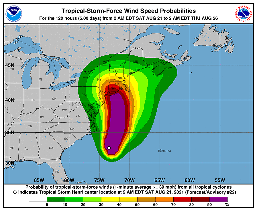
(NOAA / NHC)
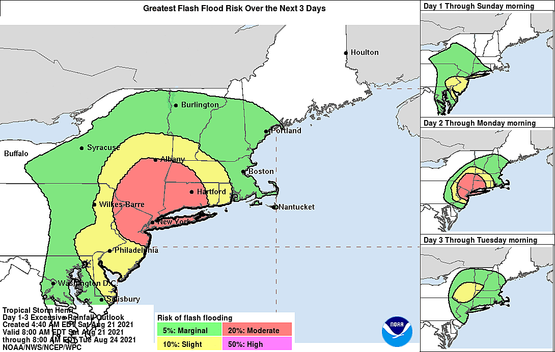
In terms of the heaviest rain, I would also add the rest of the North Jersey (above I-78) based on some of the "worst case scenario" rainfall outlooks. The rest of the Shore could see a hot-n-heavy rain band early on.

And the surf and surge coastal impacts? Surprise, surprise, they will be felt most along the Jersey Shore. Since the strongest winds will blow from the north-northeast Sunday morning, I'm most concerned about water rise and coastal flooding along our bayfront communities. (Especially Raritan Bay.)
Bottom line: The farther north and east in NJ you are, the more impactful Henri will be. The farther south and west you are, the more this storm will be a dud.
When will it start?
Saturday morning looks fine. Partly to mostly cloudy, dry, temperatures climbing from the 70s into the lower 80s.
It is possible that some showers lap up against the southern coast Saturday afternoon. But more than likely, steady rain won't spread throughout the state until Saturday evening. Some models even hold off the rain until early Sunday morning. It will take a while, but everyone in New Jersey will probably get wet from Henri eventually.
When will it get bad?
The easy answer is Sunday. Literally Midnight to Midnight. That would be the period containing the most torrential rain and gustiest wind in New Jersey.
Pinpointing it a little more, if the storm stays on track, Sunday morning will be the most inclement part of the day. Depending on what the storm does once inland, there could still be some pouring rain over the northern half of the state later. But I'd expect peak impacts between about 3 a.m. and 11 a.m.

When will it end?
Once making landfall, Henri will weaken quite a bit. So the wind threat dies by sunset Sunday.
But the real answer to the question is probably Monday. Latest guidance shows the storm continuing a turn toward the west, ending up over the Hudson Valley of Upstate New York by Sunday night. Some models even have it stalling there and sitting there through much of Monday.
Yes, we'll still be on the dry side of the storm at that point. But I think there's a good chance of rain bands intruding upon North Jersey through Monday morning. Monday afternoon, Henri should fly away to the northeast and out of our hair. The ocean will start to calm down Monday too.
What about the coast?
As I've highlighted all week, it really doesn't matter exactly where Henri makes landfall - any strong storm system between the U.S. East Coast and Bermuda throws surge and swell toward the Jersey Shore.
In this case, a category one hurricane within 100 miles of our coastline? Oh yes, the ocean will be angry, my friends.
In fact, it already is. A high risk of rip currents is posted along the entire Jersey Shore for both Saturday and Sunday. Don't expect to go for a swim - red flags will be flying on the beaches.
At the storm's peak, 5 to 8 foot ocean waves will pound the beaches, possibly causing minor to moderate erosion.
In terms of the coastal flooding picture, tidal guidance is still showing about a foot of storm surge. That's enough to put water rise in the "minor flooding" category.
As I mentioned above, residents along NJ's bayshores need to be especially vigilant about the surge, for several tide cycles in a row.
The sea's biggest crest is actually coming up during Saturday evening's high tide — 7-8 p.m. on the oceanfront, 10-11 p.m. along back bays.
By the numbers, worst case scenario?
—Rainfall... ½-1" SW NJ, 1-2" for most, 3+" north (with locally higher amounts to 5")
—Wind... Windy. Sustained 20-40 mph, gusts up to 60 mph (coast and NE NJ)
—Severe Weather... Very low threat of tornadoes
—Surf/Surge... 1-2 feet of storm surge causing minor to localized moderate flooding at high tide, 8 foot ocean waves
By the numbers, best case scenario?
—Rainfall... Widespread ½-1". 1+" possible north and east.
—Wind... Breezy. Sustained 10-20 mph, gusts up to 40 mph (coast and NE NJ)
—Severe Weather... Very low threat of tornadoes
—Surf/Surge... 1 foot of storm surge causing minor flooding at high tide, 5 foot ocean waves
Which scenario will most likely play out?
It depends on the exact track of the storm. If Henri wiggles 30 miles in either direction, it could have dramatic effects on our weather impacts and final tallies.
Given the westward trend in recent model guidance, I'd probably lean closer to the higher numbers at this point.
In any case, prepare for the worst and hope for the best.
What should I do?
Yes, there's a good chance we see true tropical storm conditions in New Jersey. Yes, there's a warning in effect. Yes, you should take it seriously.
But what does that mean you should do to prepare? Likely very little.
Take a few minutes to secure garbage cans, outdoor toys, and lawn furniture by Saturday night. Keep your cell phone charged, in case of power outages. Those who live along tidal waterways that flood "in every storm" may need to park their car on higher ground this weekend. Stay out of the ocean - it's stronger than you.
Most importantly, try to stay home during the storm, Saturday night through Sunday, if you can. It's going to be inclement, if not nasty. Possibly dangerous at times, especially to the north and east.
But a blockbuster, historic, batten-down-the-hatches, head-for-the-hills storm? Not this time, New Jersey.
Dan Zarrow is Chief Meteorologist for Townsquare Media New Jersey. Follow him on Facebook or Twitter for the latest forecast and realtime weather updates.
Remembering Tropical Storm Irene's impact on NJ, 13 years later
Gallery Credit: Dan Zarrow
BEEP BEEP BEEP: These are the 13 types of Wireless Emergency Alerts auto-pushed to your phone
Gallery Credit: Dan Zarrow
More From Beach Radio