Tropical Storm Henri’s rain bands still soaking NJ Sunday: 8 things to know
UPDATE... This article is outdated...
For the latest storm forecast information, please refer to my newest weather blog post.
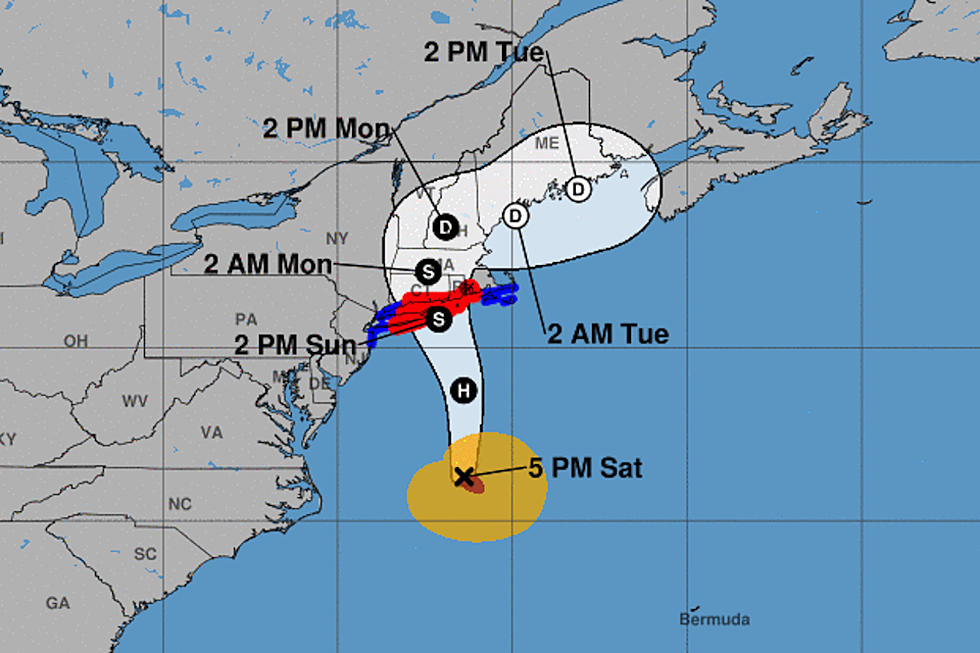
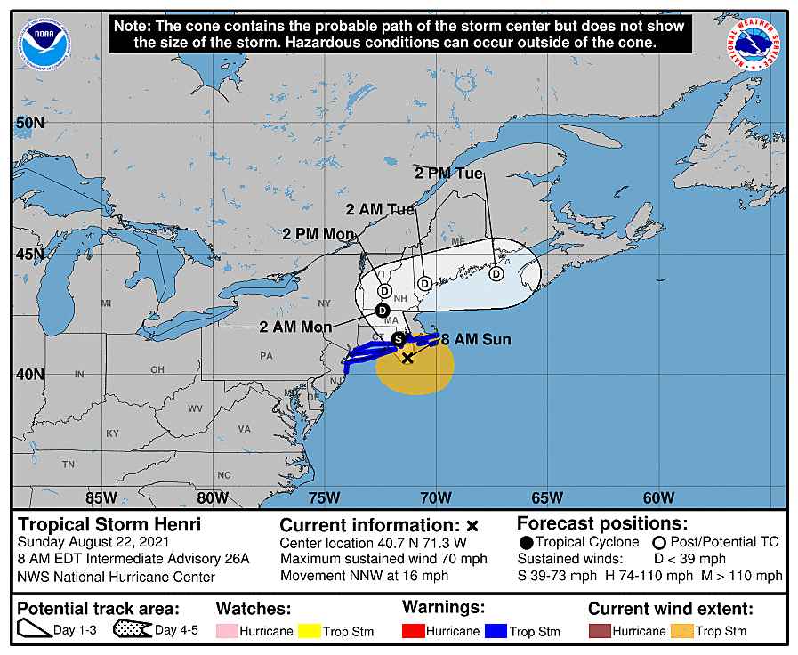
Where is Henri now?
As of 7 a.m. Sunday, Henri was downgraded from a hurricane to a tropical storm. As of 8 a.m., it had maximum sustained winds of 70 mph. The center of Henri was located 140 miles due east of Sandy Hook, N.J. And now about 50 miles from Newport, R.I.
Landfall is probably coming up around Noon Sunday. The storm decided to take the eastern track we discussed a few days ago — Long Island and Connecticut got very lucky here.
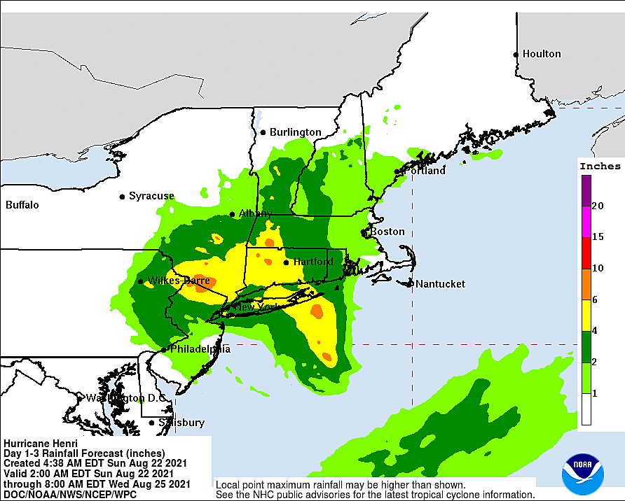
Rainfall totals so far
Some really heavy rain bands passed through New Jersey overnight. They sat and poured.
With radar estimates topping 7 inches, the heaviest rain in New Jersey clipped Long Beach Island, Ocean County. A CoCoRaHS observer in Long Beach Township confirmed that estimate, measuring 6.49 inches through 7 a.m. Sunday.
Another "bullseye" of heavy rain affected Middlesex County, around Monroe Township. Again, it looks like upwards of 7 inches of rain fell. 6.17 inches was measured in Helmetta.
There were also pockets of 2 to 3 inches of rain Saturday evening around Hudson, Essex, and Union counties. Although less than the deluge farther south, flooding led to significant travel problems.
I've heard a ton of reports of road closures, flooded basements, leaky roofs, and swollen rivers. And every additional raindrop we see Sunday into Monday is going to exacerbate the flash flooding and river flooding situation.

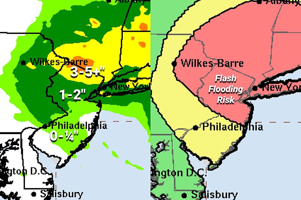
How much more rain?
It depends on where you are. Henri's rain bands continue to line up to soak the Garden State over the next 24 to 30 hours. It won't be a constant, steady rain. When it rains, it's going to pour.
Going forward, the wettest part of the state by far will be North Jersey, approximately along and north of Interstate 78. I think it's fair to expect 3 to 5 inches of additional rainfall there, give or take.
The stripe down the middle of NJ, between Interstates 78 and 195, is experiencing a band of rain as of this writing (8:30 a.m.) I could see another 1 to 2 inches here through the end of the storm.
And south of Interstate 195, you're just about done with Henri's wrath. As expected, the rainfall was very much "front-loaded". It will still feel unsettled and tropical, of course. And occasional showers are possible. But South Jersey is firmly in Henri's dry slot now - big, bad tropical rainfall and flooding are unlikely now.
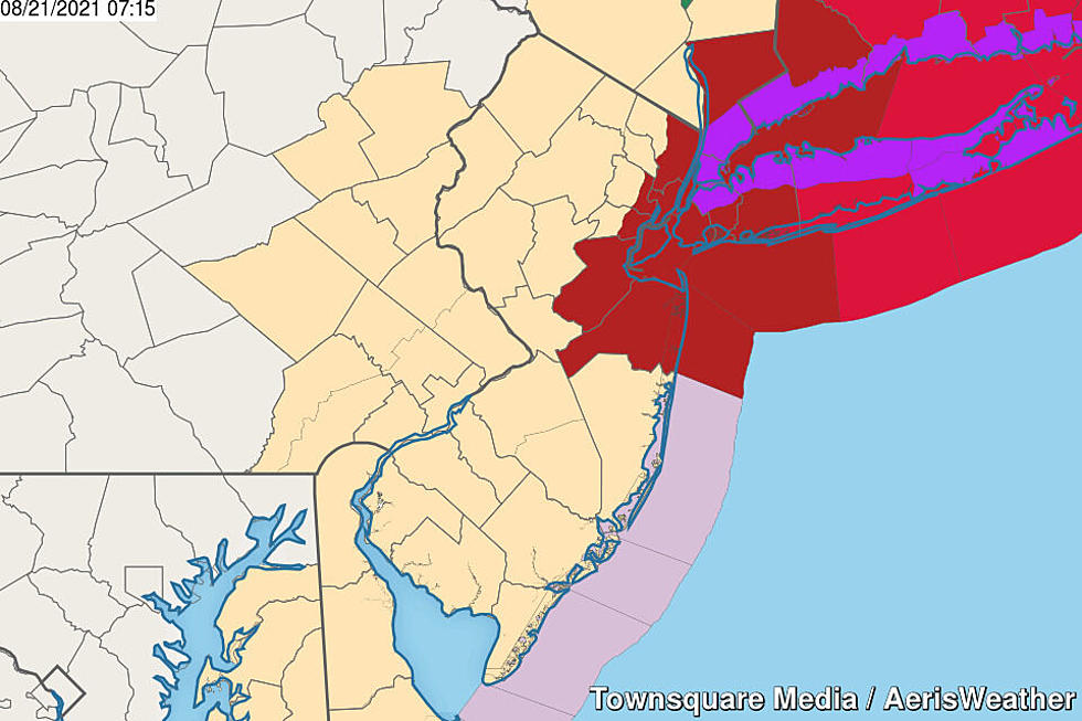
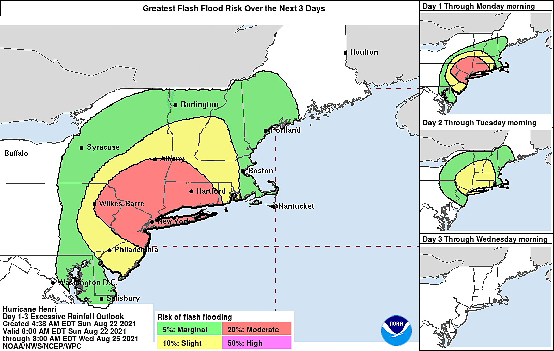
Flash and river flooding risk
With super-saturated soil and overwhelmed drainage systems, it won't take much heavy rain to cause flash flooding issues through the rest of the day. Remember that "flooding" often looks like "large puddles" - but they can be deep, swift, and very dangerous. Never attempt to drive, walk, or swim through flooded areas.
Several NJ waterways are approaching or have surpassed flood stage. Notably, the Passaic River, Pequannock River, and Saddle River around Bergen, Passaic, Essex, and Morris counties are in minor flood already. And remember, that's the area expected to see another 3+ inches of rain. Not good.
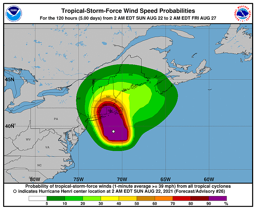
Wind only a minor concern at this point
As Henri's forecast track drifted east, away from New Jersey, it became clear that wind would be marginal here in New Jersey. We could still see some gusts on the order of 40 mph - especially along the eastern and northern edges of the state.
But I highly doubt the Tropical Storm Warning will verify - that requires sustained winds of 39+ mph.
Two more "high" high tides Sunday
The Atlantic Ocean is at high tide as I'm writing this, in the 8 a.m. hour. Back bays will crest approximately 2 to 3 hours later, around 10-11 a.m. Tidal guidance still shows a storm surge of about a foot. We did see a round of minor coastal flooding in "the usual spots" Saturday night. And I would expect about the same this time around.
There's one more precarious high tide cycle coming up Sunday evening, with widespread minor flooding of tidal waterways. Monday's high tides could come close to minor flood stage too.
The risk of dangerous rip currents and rough surf will remain high through at least Monday.
When will it end?
The basic answer is still Monday. But again, the detailed answer is hazy and also depends upon where you are.
Once Henri makes landfall, it is going to slow down and push westward a bit. That wobble will keep North Jersey under the influence of Henri's rain bands through about midday Monday. (As I mentioned earlier, South Jersey is pretty much done already.) It will be breezy, if not windy, at times through early Monday as well.
A few models do put rain into Monday afternoon, but I favor an earlier departure.
Skies will clear from southwest to northeast through Monday afternoon and evening.
Continuing coverage
With "the brunt" of Henri here in New Jersey Sunday, our on-air and digital content teams are on the job to bring you the latest on road closures, flood damage, power outages, and more. New Jersey Fast Traffic and Instant Weather play every 15 minutes all day every day on New Jersey 101.5.
And I'll be here too! As the storm continues to develop and drench the Garden State, you'll be the first to know if anything changes.
I truly hope you and your loved ones are safe and snug somewhere for the duration of Henri's fly-by this weekend. I'm definitely looking forward to brighter, drier, warmer days ahead this week!
Dan Zarrow is Chief Meteorologist for Townsquare Media New Jersey. Follow him on Facebook or Twitter for the latest forecast and realtime weather updates.
Remembering Tropical Storm Irene's impact on NJ, 13 years later
Gallery Credit: Dan Zarrow
BEEP BEEP BEEP: These are the 13 types of Wireless Emergency Alerts auto-pushed to your phone
Gallery Credit: Dan Zarrow
More From Beach Radio