NJ Hurricane Henri update: Wet and windy, but not a ‘worst case scenario’
UPDATE... This article is outdated...
For the latest storm forecast information, please refer to my newest weather blog post.
The Latest on Hurricane Henri
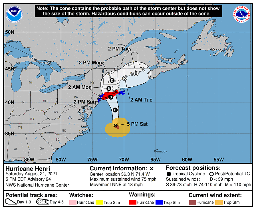
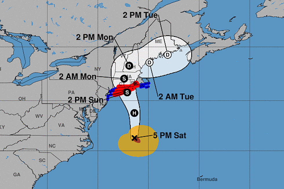
—Henri is still a hurricane (minimal category one) as of 5 p.m. Maximum sustained winds holding steady at 75 mph.
—The latest forecast track and model guidance nudged Henri back to the east, away from NJ. Most likely landfall on the eastern end of Long Island (Suffolk County).
—New Jersey's forecast is trending toward a middle ground track and middle case scenario (not quite worst-case, not quite best-case). Inclement, if not nasty at times. Possibly dangerous during the peak of the storm, to the north and east.
—New Jersey's biggest impact from Hurricane Henri will likely be the heavy rain and potential flooding. The wind and minor storm surge threat can't be ignored though.
—It's already raining in South Jersey, already on the northwestern edge of Henri. (The center of circulation is about 260 miles southeast of Cape May, N.J.)

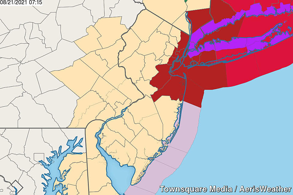
Advisories
—Tropical Storm Warning... eastern Bergen, eastern Essex, Hudson, Middlesex, Monmouth, and eastern Union counties... Tropical cyclone advisories don't have a traditional expiration time - it will be cancelled when the threat for dangerous winds has subsided.
—Flood Watch... all 21 counties of New Jersey... Until Monday morning... Heavy rain may cause flash and river flooding.
—Coastal Flood Advisory... Cape May, Middlesex, Monmouth, and Ocean counties... Until early Sunday morning... Storm surge may cause tidal waterways to rise and flood nearby low-lying areas.
Timeline
—Saturday evening... As of this writing (5 p.m.), the outermost band of Hurricane Henri is already lapping up against NJ's southern coast. Pockets of moderate rain will continue spreading westward and northward.
—Saturday night to early Sunday morning... As the center of Henri makes its closest pass to New Jersey, rain will become steadier and more widespread between about Midnight and daybreak Sunday.
—Sunday mid to late morning... Rain continues. Likely the period of strongest winds.
—Sunday afternoon... Models are really going full-bore on a band of heavy rain riding around Henri's circulation from lunchtime onward. Mainly affecting northern and coastal NJ.
—Sunday night... Still raining, especially to the north. But also calming down. Especially in terms of wind. And especially drying out across the southern half of the state (which may be all done with the storm at this point).
—Monday morning... Bands of moderate to heavy rain remain possible for North Jersey.
—Monday midday to afternoon... Eventually, Henri will get swept away to the northeast, putting an end to the rain and a return to quiet, warm, humid, summery weather.
One More Thing...
Allow me to quote myself from multiple Fred and Henri updates earlier in the week:
Never underestimate the rainfall potential of tropical moisture.
In my Saturday morning Henri weather blog post, I also said:
What does that mean you should do to prepare [for Henri]? Likely very little.
At first glance, these statements seem to contradict each other. But they don't, really. What would you do differently to prepare for a storm if you thought you'd get 10 inches of rain instead of just one? Probably nothing. What would you do differently if you knew 60 mph winds were coming, instead of 30 mph? Same thing.
I do want to add one important asterisk to the forecast information I'm about to type. While we've now dialed in a pretty confident track forecast, far from a "worst case scenario" for NJ, the storm is still subject to "wiggle" in either direction. Even a wobble of 25 miles could have a dramatic effect on what falls/blows from the sky.
In addition, rainfall totals will be heavily influenced by the exact location, orientation, and speed of the tropical rain bands that will form. (I hesitate to mention that there is an outlier model pumping out a localized 14 inches of rain over New Jersey, a flash flood catastrophe. Again, outlier.)
That's what you'll find rampant "+" plus signs attached to my rainfall forecasts below. I've tried to give you the best "most likely" estimate of expected conditions. But I also think it's important to realize there's still a chance things go off the rails and we ultimately lean toward a heavier, more impactful, more serious worst case scenario.
The Warning Area
(eastern Bergen, eastern Essex, Hudson, Middlesex, Monmouth, eastern Union)
—Rain... 2 to 4+ inches
—Wind... Sustained tropical storm force 40 mph possible, gusts 40 to 60 mph
—Surge/Surf (Middlesex & Monmouth counties): Approximately a foot of storm surge. Saturday evening's, Sunday morning's, and possibly Sunday evening's high tide cycles could cause widespread minor coastal flooding. Given the strongest winds will blow from the north-northeast, the Raritan Bay shore and back bay areas will be most prone to water rise. A high risk of dangerous rip currents will continue along the oceanfront, accompanying 5 to 8 foot waves.
—Surge/Surf (Hudson County)... About a foot of water rise is possible along the Hudson River at high tide, which could lead to flooding of streets or other low-lying areas.
The Rest of North Jersey
(western Bergen, western Essex, Hunterdon, Morris, Passaic, Somerset, Sussex, western Union, Warren)
—Rain... 2 to 3+ inches
—Wind... Gusts 25 to 40 mph (lowest to the west, highest to the east)
—Surge/Surf... This one's easy. Zero!
The Rest of the Shore
(Atlantic, Cape May, Ocean)
—Rain... 2+ inches
—Wind... Gusts could top 40 mph, but sustained winds should stay below tropical storm force
—Surge/Surf... Approximately a foot of storm surge. Saturday evening's, Sunday morning's, and possibly Sunday evening's high tide cycles could cause widespread minor coastal flooding. Especially farther north along the coastline. Given the strongest winds will blow from the north-northeast, back bay areas will be most prone to water rise. A high risk of dangerous rip currents will continue along the oceanfront, accompanying 5 to 8 foot waves.
South and West
(Burlington, Camden, Cumberland, Gloucester, Mercer, Salem)
—Rain... 1 to 2+ inches (mainly early on)
—Wind... Breezy, at best. Top gusts maybe 20 to 30 mph.
—Surge/Surf... Tidal guidance shows a half-foot of water rise along the Delaware River and Delaware Bay, but I don't think that's enough to cause widespread flooding issues. Actualy, since the strongest winds will blow from the north-northeast, we'd more likely face low levels than high.
Action Steps
—Secure outdoor loose objects that may become projectiles, including garbage cans, lawn furniture, etc.
—Keep your cell phone charged in case of power outage or emergency.
—Plan to stay home during the brunt of Henri's wind and rain, if possible, from Saturday night through much of Sunday.
—Expect travel disruptions during and after the storm, due to downed trees, power outages, and flooding.
—Turn Around Don't Drown: Never attempt to drive, walk, or swim through flooded areas.
—No need for a "bread and milk" run, as it's not a long-term event. It'll all be over on Monday.
Dan Zarrow is Chief Meteorologist for Townsquare Media New Jersey. Follow him on Facebook or Twitter for the latest forecast and realtime weather updates.
Remembering Tropical Storm Irene's impact on NJ, 13 years later
Gallery Credit: Dan Zarrow
BEEP BEEP BEEP: These are the 13 types of Wireless Emergency Alerts auto-pushed to your phone
Gallery Credit: Dan Zarrow
More From Beach Radio