Monday-Tuesday not really a “snow” storm for NJ, ice is bigger concern
I feel a little more confident in putting together this forecast, compared to this morning's update. I still don't think we have a perfect handle on New Jersey's impending snow-ice-rain maker. But we're getting there.
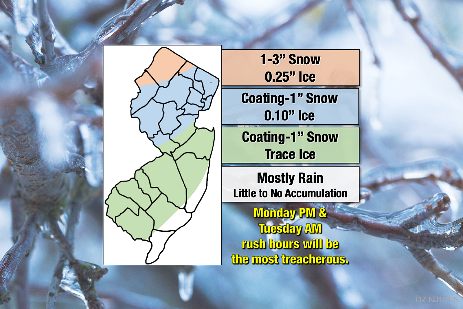
For this post, I decided to break the state (and my discussion) into four sectors, matching my latest forecast map. For each area, I will offer an overview of storm timing, totals, and impacts. Find the color for where you live and where you work, and scroll down.
If you are looking for more background on this storm system, a primer on wintry precipitation types (snow vs. sleet vs. freezing rain), an explanation of this storm's high uncertainty, and a peek into the long-range forecast, please review my weather blog post from Sunday morning...
Advisories
First of all, our latest headline is the (expected) issuance of a Winter Weather Advisory. As of this writing, the advisory covers all or part of 9 counties in central and northern New Jersey:
—1 p.m. Monday to 1 p.m. Tuesday... Sussex County.
—1 p.m. Monday to 7 a.m. Tuesday... Hunterdon, Mercer, Middlesex, Morris, Somerset, and Warren counties.
—6 p.m. Monday to 6 p.m. Tuesday... western Bergen and western Passaic counties.
An advisory means that wintry weather (snow and/or ice) may cause minor travel impacts. Sometimes this "formal heads-up" serves as a trigger for pretreatment operations and/or school delay/closure decisions. For most New Jerseyans, it means we are facing one or two headache commutes — Monday evening and Tuesday morning.
Far North Jersey (Orange)
Ah, far North Jersey — the state's natural winter wonderland! Colder temperatures for the duration will lend to bigger snow and ice accumulations here. Eventually — the precipitation will be slow to start.
—Monday Morning and Afternoon... Fairly quiet. A quick burst of light snow is possible, but most precipitation should stay to the south.
—Monday Evening to Tuesday Morning... Moderate to heavy snow arrives Monday evening, potentially leading to some quick accumulation on the cold ground. A flip to icy mix (sleet/freezing rain) is likely after Midnight, leading to increasingly slick conditions.
—Tuesday Afternoon... Precipitation tapers off, ending completely by about dinnertime. Residual icy spots are likely through the evening commute.
—Snow Accumulation Forecast... up to 3 inches.
—Ice Accumulation Forecast... about a quarter-inch. (That's a lot.)
North and West of the Route 1 Corridor (Blue)
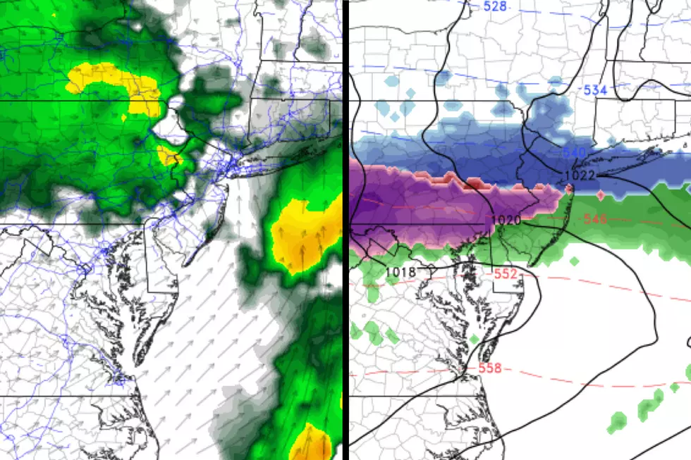
In New Jersey, U.S. Route 1 runs 66 miles from the Trenton-Morrisville Bridge in Trenton to the George Washington Bridge in Fort Lee. It serves as an incredibly convenient boundary line for describing winter weather forecasts. In this case, model consensus shows this area to be the most precarious for flipping from snow to icy mix to (eventually) rain.
—Monday Morning... Fairly quiet for the early commute. Snow showers may drift in by lunchtime.
—Monday Afternoon... Light to moderate snow, leading to reduced visibility and some accumulation. Road conditions may very well become slushy and slippery for your ride home.
—Monday Evening... Rising temperatures both at the surface and aloft force a transition from straight snow to wintry mix. You may very well flip-flop between plain rain and sleet/freezing rain throughout Monday night. The hours surrounding Midnight will be most conducive to icing.
—Tuesday Morning and Afternoon... Probably just rain falling from the sky. But watch for residual ice on the ground from the overnight. Precipitation tapers from west to east by late afternoon.
—Snow Accumulation Forecast... a coating to an inch.
—Ice Accumulation Forecast... about a tenth of an inch.
South and East of Route 1, Non-Coastal (Green)
Falling just outside of the advisory area, this is indeed going to be another mainly rain event. But don't let your guard down just yet, as light snow and ice could cause some visibility issues and slipperiness concerns.
—Monday Morning... Snow showers are possible. No significant impediment to the early commute.
—Monday Afternoon... As temperatures rise, precipitation will eventually become all plain rain by the evening commute. Within the transition from snow to rain, a brief period of icy mix could contribute to slight slipperiness issues.
—Monday Evening through Tuesday Afternoon... Periods of cold, uncomfortable rain. Little to no additional accumulation is expected. Rain should taper from west to east by Tuesday evening's rush hour.
—Snow Accumulation Forecast... a coating to an inch.
—Ice Accumulation Forecast... a trace (light glaze).
Immediate Coastline (White)
Temperamental temperatures make this a tricky forecast, but not along the immediate coast. With temps both at the surface and aloft holding above freezing for the duration, I don't think we're facing any substantial accumulations here.
—Monday Morning... A quick period of light snow is possible. No travel issues are anticipated.
—Monday Afternoon... Rain.
—Monday Evening... Rain.
—Tuesday Morning... Rain.
—Tuesday Afternoon... Rain, tapering off just before the evening rush hour.
—Snow Accumulation Forecast... little to none.
—Ice Accumulation Forecast... little to none.
Bottom Line
As this post's headline suggests, this is really not shaping up to be a classic snow storm for New Jersey. An ice storm, maybe. With minor to moderate impacts across the Garden State, especially the farther north and west you are. It's not a bread and milk storm, although do expect to see widespread salting and brining operations before, during, and after the storm.
There are still some significant question marks surrounding precipitation type — and honestly, the science of meteorology only goes so far in making a forecast like this. Best-case scenario, the icing never happens and we get just plain ol' rain. (And that would be fine by me.)
Literally a degree or two on the thermometer could be the difference between puddles and a skating rink.
I highly recommend you utilize the holy winter storm trinity — common sense, patience, extra time — during both Monday evening's and Tuesday morning's rush hours.

My next weather blog will be published in the 6 a.m. hour Monday morning.
Dan Zarrow is Chief Meteorologist for Townsquare Media New Jersey. Follow him on Facebook or Twitter for the latest forecast and realtime weather updates.
More From Beach Radio