Warm temps continue for NJ, but weather turns more unsettled
Wow, Monday sure was a beautiful day, wasn't it? I'm pleased I was able to spend most of it outside — socially distanced in the backyard, of course. While the warmth will continue for approximately two more days, skies will turn cloudier and our weather forecast turns a bit wetter too.
I will mention right off the bat that this remains a rather uncertain forecast. And I'm almost approaching it with fresh eyes, as models do show some changes. We are starting to zero in on two important things: 1.) when it's going to rain, and 2.) just how warm it will get/stay.
Weatherwise, this Tuesday morning is pretty typical for early April. 30s inland, 40s coast and urban areas. We'll top out in the lower to mid 60s Tuesday afternoon. And, with a less prominent sea breeze, even the Jersey Shore could hit 60+ degrees.
While you will catch partial sunshine (at least) early on, clouds will gradually increase as the day presses on. Some model guidance hints as a little shower or sprinkle at some point too.
The better chance for showers and thunderstorms will hold off until Tuesday night. In fact, given the (relative) heat and humidity in our atmosphere, some of those storms could be on the strong side, featuring gusty winds and a brief pocket of heavy rain. The Storm Prediction Center has painted SW NJ into a "Slight Risk" for severe weather — that's level 2 of 5 on their scale.
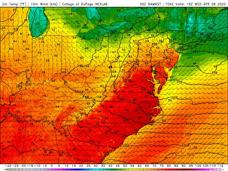
Wednesday will probably be our warmest and most unsettled day of the week. The forecast is also the most complicated of the week, as warm air bubbling up from the southwest will be countered by cooler marine air creeping in from the northeast.
North Jersey will get stuck in the mid-upper 50s. On the flip side, inland central and southern NJ could very well pop over 70 degrees. Mostly cloudy skies will join one or two rounds of showers and thunderstorms Wednesday.
A reminder that Wednesday night is the start of Passover. Sundown occurs around 7:31 p.m.
Thursday will be our cold front day. One more push of rain is likely around midday Thursday. Then, following the frontal passage, a gusty northwesterly wind will kick up. (Possibly gusting to 40 mph.) That will usher in cooler air.
So, while most of the Garden State should hold onto 60s for Thursday afternoon, we'll only see highs in the lower 50s by Friday afternoon. An unseasonably cool Good Friday.
And it will remain windy Friday too, sustained at 15 to 25 mph with gusts again to 40 mph. Skies look mostly sunny to me. Although some models are suggesting an afternoon shower. (I don't fully buy that rain chance, and opted to leave it out of my on-air forecast so far.)
We continue through the Saturday will be mostly sunny and breezy, with highs improving to the mid 50s.
And thermometers will return to seasonable levels on Sunday, in the 55 to 60 degree range. Still breezy, and with increasing clouds. In addition, our next storm system will bring in some rain around Sunday late afternoon. So you'd best get your Easter bonnet photos and Easter egg hunts done early in the day.
More From Beach Radio