Tuesday NJ weather: Temperatures rise, fire danger remains high
The Bottom Line
High pressure will be in control of our weather for the next three days. That is a protective dome of sinking air. It is warm air. It is dry air.
So this is a pretty spectacular, summerlike forecast. Pollen levels and fire danger remain high, of course. And they’ll stay elevated until we get significant rain.
We are looking ahead to cooler, cloudier, wetter weather at the end of the week.

Tuesday
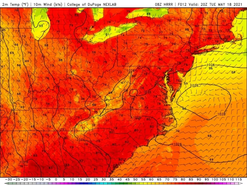
We face a very wide diurnal range Tuesday - that is the difference between the morning low and afternoon high temperatures. Many 40s on the temperature map early on. Highs reaching the upper 70s to around 80. That’s a full 30+ degree difference! That only happens when the air is dry and skies are clear.
And that’s exactly what we have in the forecast. Mostly sunny, dry, and warm. Another beautiful day, with temperatures about 5 degrees above seasonal normals. A light sea breeze will keep beaches along the Jersey Shore about 10 degrees cooler than just a few miles inland (probably in the 60s).

It is worth noting that a weak wave will drift south through New England Tuesday. I believe 1.) it will stay far enough east and 2.) our atmosphere will be too dry to sustain substantial raindrops. But it will be the only big driver of clouds through New Jersey Tuesday. (Hence the "mostly" sunny description in my on-air forecast.)
In addition, there are still two active wildfires in Ocean and Burlington counties. Areas in the vicinity may experience hazy or cloudy skies at times, depending on the smoke and wind conditions.
Tuesday evening looks equally spectacular. It will be clear and comfortable, with lows dipping into the mid 50s or so.
Wednesday
Sunny, warm, and dry. Wow.
Highs will push into the lower to mid 80s on Wednesday, probably the warmest day of the week. You are definitely going to sweat, especially in direct sunshine. But at least we won’t be “chewing through the air,” as humidity levels stay nice and low. (Dew points in the 50s.)
Thursday
Morning lows in the 60s will give us a headstart to the lower 80s once again. Clouds will roll in throughout the day. Our next chance of rain showers will develop Thursday evening, as early as 5 p.m.
Friday
Big changes, thanks to a backdoor cold front and a couple of weak atmospheric waves.
First, showers from the previous evening may linger through midday Friday.
Second, skies will be cloudy.
Third, temperatures will be much cooler. Although this piece of the forecast is very difficult to pinpoint, it’s pretty clear highs will crash into the 60s. Some models are going as low as 60-ish degrees. I’ve seen some solutions indicating 70-ish is possible early Friday. So I’ve settled on a middle-of-the-road prediction for now: mid 60s.
The Weekend & Beyond
Guidance suggests another round of showers will ride through the sky early Saturday. It will probably stay overcast for most of the day. And temperatures will once again be stuck in the below-normal 60s.
Sunday looks better. Breaks of sun will help temperatures into the seasonable lower-mid 70s. There will be one more chance of rain late Sunday. Previously, this looked like a period of steady-heavy rain. (Which we could really use right about now.) Latest model forecast have disintegrated that chance to just scattered showers. We'll see how things continue to develop, and keep fingers crossed.
No big concerns as we head through the last full week of May next week. Seasonable temperatures and one or two batches of rain seem most likely. It’s too early to preview the big Memorial Day Weekend - hard to believe that’s only a week and a half away!
Dan Zarrow is Chief Meteorologist for Townsquare Media New Jersey. Follow him on Facebook or Twitter for the latest forecast and realtime weather updates.
When Ocean and Monmouth County Police saved the day
More From Beach Radio