Remnants of Delta: How much rain for NJ, and when it will end
In July, Tropical Storm Fay became the first tropical cyclone to make its initial landfall on New Jersey since 1903, delivering a stormy, soggy day.
In August, less than a month later, Tropical Storm Isaias knocked out power for over a million Jersey residents.
In September, the remnants of Sally delivered over 3 inches of rain to much of the Garden State.
And here we are in October, with yet another batch of tropical moisture to deal with — the remnants of Hurricane Delta.

As you are reading this, Delta's impacts on New Jersey have already begun, as initial showers arrived Sunday afternoon. The end result will be a thorough soaking throughout Monday. Let's break down what you need to know:
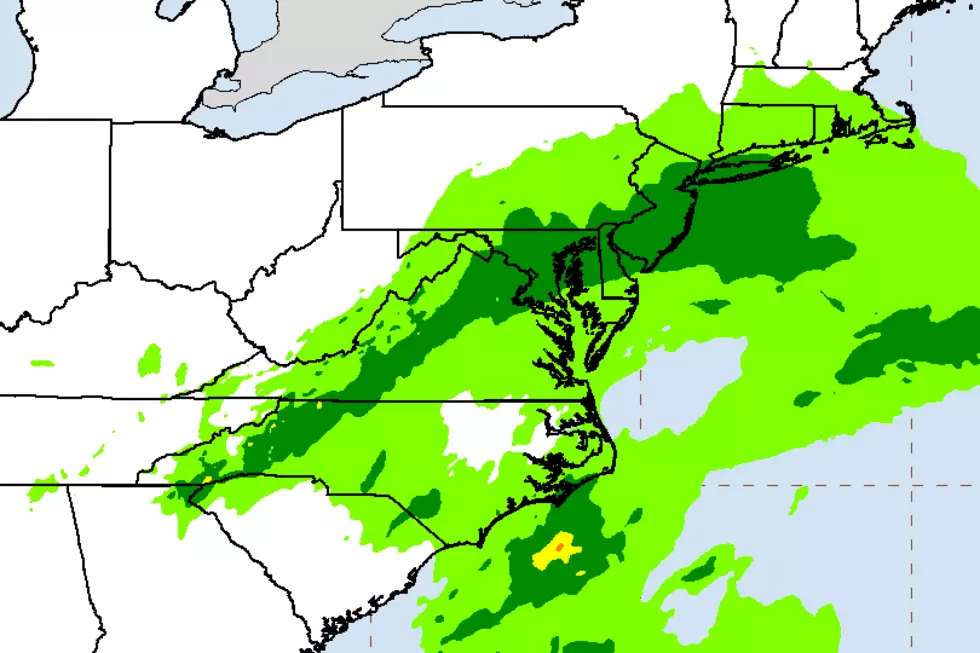
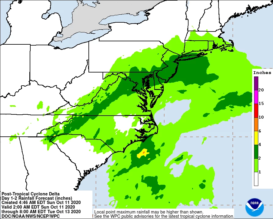
—How much rain? Models are strongly pointing toward 1 to 3 inches of total rainfall over New Jersey during the day Monday. Locally higher amounts to 4 or 5 inches can't be ruled out. The highest totals are expected to be along southern and coastal parts of the state. The lowest totals will be found in northwestern New Jersey.
—Any flooding issues? The ground is thirsty, as we really haven't had much rain over the course of the last month. (Read: The weather has been beautiful!) However, we can't talk about tropical downpours and up to 5 inches of rain without mentioning flooding. While we're not talking about widespread "walls of water," there could absolutely be some sizable puddles causing travel headaches during the heaviest rain.
—Timing of the heaviest rain? Monday morning, from about 4 a.m. to 11 a.m., give or take. Unfortunately, that covers the heart of the morning rush.
—When will the rain end? Rain will become less steady and more scattered Monday afternoon. But showers will potentially continue into Monday night. And I don't think we'll fully clear away from the raindrops until a cold front arrives mid-morning Tuesday.
—What about wind? To be clear, this is not a tropical storm anymore. Still, I think we're in for some breezy to windy weather. Top gusts to the south/east will probably approach 40 mph.
—What about coastal flooding? Even though Delta's remnant low is approaching from the southwest, the wind field in our corner of the storm will blow from the east-northeast. An on-shore wind. That will push some ocean water toward the Jersey Shore. So we are looking at a foot or two of storm surge, lasting for 1 to 3 high tide cycles. The highest tide will occur Monday afternoon, during which minor to localized moderate flooding of tidal waterways is likely. That will exacerbate any poor drainage flooding that may be ongoing from the early morning downpours.
—Any chance for a break of nice weather Monday? Not really. Hopefully you get the idea that it's going to be a soggy, cloudy, windy day. Temperatures will barely touch the 60s. A bagful of yuck.
—How does the rest of the week look? Pleasant, mild weather resumes for Tuesday, Wednesday, and Thursday. The sun comes out, the wind calms down, and high temperatures should push into the 70s all three days. Next storm system will be a cold front arriving on Friday. That will bring along our next batch of rain, and also knock back temperatures to more autumnal levels (60-ish) for next weekend.
Be smart, stay safe, and keep dry out there! Umbrellas up, windshield wipers on, and headlights on too!
Dan Zarrow is Chief Meteorologist for Townsquare Media New Jersey. Follow him on Facebook or Twitter for the latest forecast and realtime weather updates.
More From Beach Radio