NJ flips back to sunshine and seasonable temperatures for Tuesday
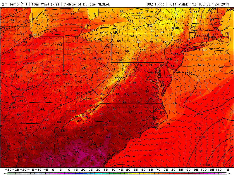
On Monday, the weather stations at Mannington Township (Salem County), Moorestown (Burlington County), Upper Deerfield (Cumberland County) and Newark Liberty International Airport (Union/Essex County) hit 93 degrees. That's a degree shy of EWR's record high of 94 set in 1970. While autumn kicked off with heat and humidity, a cold front has already put an end to that sultry streak.
You may still notice a hint of stickiness as you step outside on this Tuesday morning, especially the farther south you are. Temperatures are generally in the 60s, with clearing skies and decreasing humidity. While we did see a few showers overnight, the rest of Tuesday will be dry. It should turn into a very nice day, with a fresh northwesterly breeze up to 20 mph. High temperatures will be limited to the mid to upper 70s — upwards of 15 degrees cooler than Monday, and still about 5 degrees warmer than normal for late September.
A high risk of rip currents continues for the Jersey Shore.
With a dry atmosphere and just a few clouds overnight, there will be a little chill in the air for Tuesday night. Low temperatures will range from about 50 degrees (North Jersey) to the upper 50s (cities and coast).
We'll be treated to another beautiful day on Wednesday. Sunny skies, lighter winds, and highs again in the mid to upper 70s.
Some changes arrive for Thursday, just another bump on the roller coaster of autumn. First, we'll feel a warmup — highs will jump into the lower 80s Thursday afternoon. Passing clouds will obscure the blue sky a little bit, but it still looks like a nice day overall.
A cold front is expected to pass through New Jersey starting Thursday afternoon. But forecast models have been pretty firm in showing a mainly dry frontal passage. I'm still including an isolated shower in my forecast, mainly in North Jersey. But once again, we're not facing any kind of major storm system, soaking rain, etc.
Friday will mark a return to sunny, dry, pleasant weather with highs back in the mid to upper 70s.
The weekend is shaping up better (a.k.a. drier) A southwesterly wind will fuel a warmup for Saturday, pushing high temps into the lower to mid 80s. There will be some cloud cover, and maybe some rain showers around. But those raindrops now look widely scattered, and primarily in the evening and overnight hours.
Sunday looks to be the cooler day of the weekend. Thermometers in the upper 70s to around 80 degrees, with early clouds giving way to sunshine.
Temperatures should fall to seasonable levels, in the lower to mid 70s, to close out the month of September on Monday.
Still no significant, imminent concern in the tropics. Tropical Storm Jerry will bring rain and wind to Bermuda over the next 24 to 36 hours. Tropical Storm Karen is doing the same for Puerto Rico and the Virgin Islands Tuesday. And Tropical Storm Lorenzo continues to strengthen and charge through the far eastern Atlantic Ocean.
More From Beach Radio