
Rain, wind, cold, snow: Timeline for NJ’s big Sunday storm
The Bottom Line
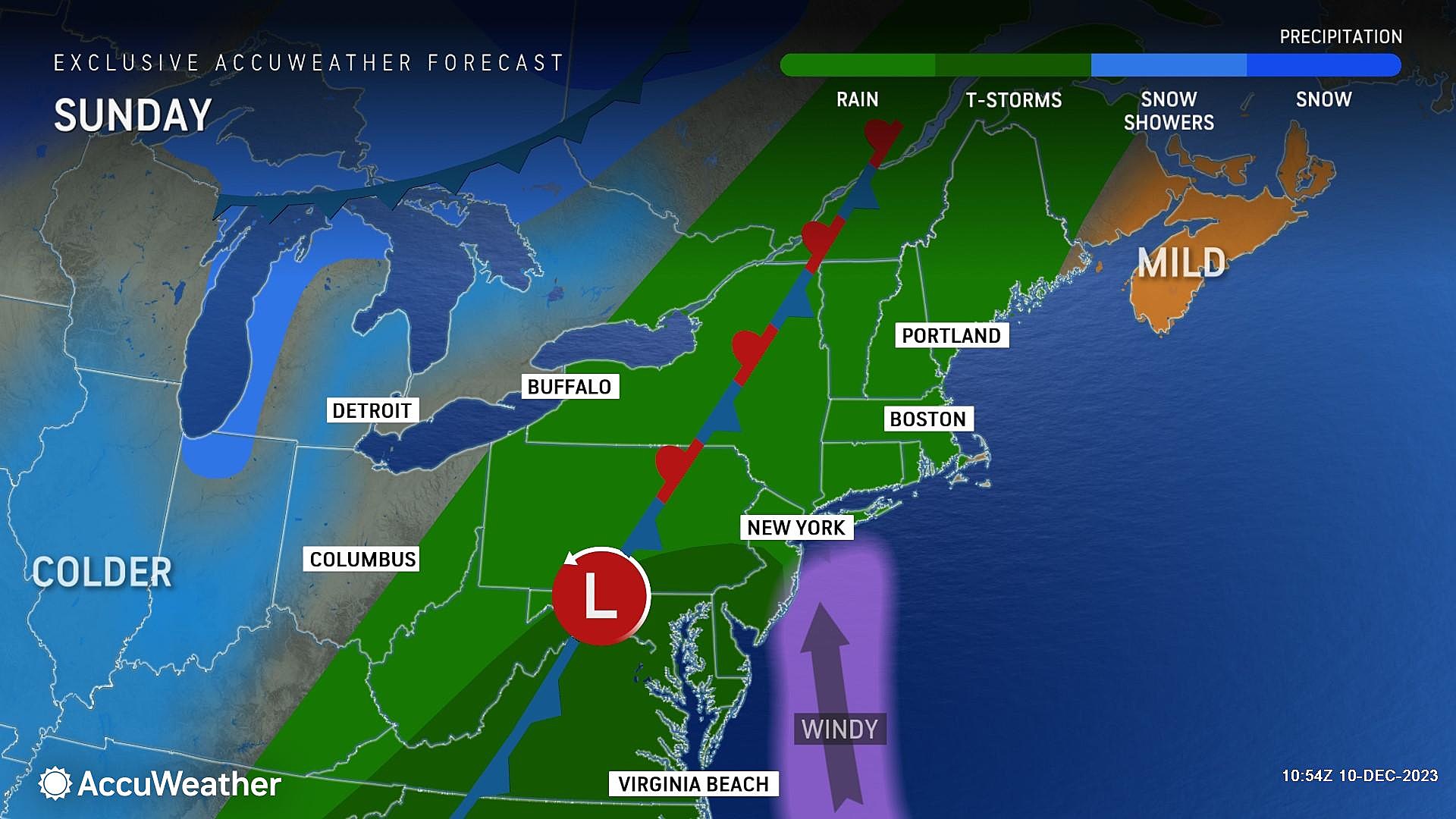
This weekend is set to end with a "bang" as a strong cold front looms closer and closer to New Jersey. Our weather is going to turn quite stormy Sunday, as torrential rain and fierce winds blow through the Garden State. The worst weather is going to come Sunday night, with impacts expected to stretch through the Monday morning rush hour.
We do have to ring alarm bells for flooding and power outages. And maybe some slushy snowflakes early Monday morning.
Let's run through the latest forecast details - specifically focusing on the timing and the most likely impacts - so you know exactly what to expect.

Timeline
–Sunday Morning... Quiet so far. We start the day with some light fog, thick clouds, and a warm breeze. High temperatures will be on the warm side, spiking to around 60 degrees by Noon. You will salvage a few hours of dry, storm-free weather early on Sunday.
–Sunday Midday... Between about 10 a.m. and 1 p.m., rain will spread into the Garden State. It will be scattered at first - hit or miss. But I can't really classify the initial rain as "showers," as there will be pockets of heavy stuff at onset.
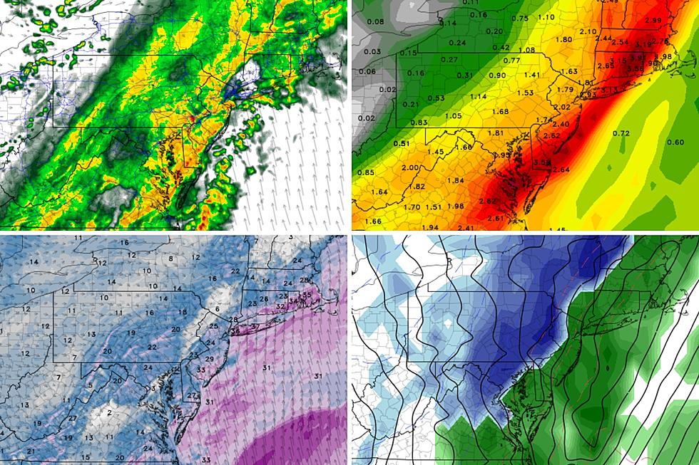
–Sunday Afternoon... Our weather will continue to go downhill, as rain becomes steadier and more widespread. Still with pockets of heavy stuff. As the ground becomes saturated and storm drains kick into overdrive, ponding and flooding will become an increasing concern. Some locations in NJ could see an inch of rain in the bucket by sunset.
–Sunday Evening... The brunt of the storm, between about sunset (5 p.m.) and Midnight. As a band of particular heavy rain sets up, the wind will really kick up too. Heavy, wind-driven rain is nasty business.
–Sunday Overnight... After Midnight, the rain will continue. In addition, we will start to feel the cooldown effects of this cold front. Temperatures will drop from the 50s into the 30s by daybreak Monday, with a "whoosh" of northwesterly wind. Rain may mix with (or transition to) snow just before sunrise, especially to the north and west.
–Monday Morning... Rain and snow showers will continue through mid to late morning Monday. The early commute could be tricky, due to slippery roads (either wet or slushy). By lunchtime, precipitation should be wrapping up. But it will be a blustery, cold day with temperatures barely rebounding past 40 degrees in the afternoon.
Impacts / Advisories
–Rain... By far, the biggest and most precarious storm impact for New Jersey. Rainfall totals between midday Sunday and midday Monday will average about 2 inches across the state. Possibly as low as 1 inch to the northwest. Meanwhile, some models do suggest 3+ inches of rain is possible along the coast and to the south. No matter where you are, that is a lot of rain. Flash flooding could become a big issue. Especially in areas where leaf piles are blocking gutters and storm drains. All 21 counties of New Jersey fall under a Flood Watch from Sunday afternoon through Monday afternoon, given the threat of street and stream flooding.
–Wind... Yes, it will get windy. Before, during, and after the storm. Wind gusts may push to 40 mph around New Jersey, which is enough to cause driving/walking difficulties, bring down branches, and cause sporadic power outages. I could see some 50 mph gusts along the coast, as the storm fires up and taps into a screaming-fast low-level jet about a mile overhead. Technically that is not quite strong enough to be called "damaging" - but it is absolutely worth some extra attention. A Wind Advisory is posted for the immediate coast (Monmouth, Ocean, Atlantic, and Cape May counties) during the brunt of the storm, from 4 p.m. Sunday to 1 a.m. Monday.
–Cooldown... While Sunday will reach a high temperature in the lower 60s, temperatures will drop sharply late-night. We will be in the 30s as you wake up Monday morning - above freezing, but noticeably colder. For the entire week, we will see highs only in the lower-mid 40s, below normal for mid-December.
–Snow... The cooldown will occur before the rain machine shuts off, so there is a good chance for a transition to wintry mix or snow early Monday morning. The best chance for a wintry finish to this storm system would be to the north and west. (Let's say west of the NJ Turnpike corridor.) I do not think snow accumulation will become a huge issue - it's not the headline of this storm system. However, we would be foolish to not consider the possibility of a heavy snow band dropping a quick inch on a mountaintop somewhere, despite the soaking wet ground. While a Winter Weather Advisory has been issued for the adjacent Pocono Mountains of NE Pennsylvania (Carbon and Monroe counties), no such alarm bells are necessary for NJ at this time.
–Coastal Flooding... This is not a coastal storm. The strongest winds will be blowing primarily from a westerly direction, pushing ocean water away from our coastline. However, the initial southerly flow could be enough to stockpile tidewater in back bays, leading to a higher-than-normal overnight high tide cycle. A Coastal Flood Advisory has been issued for Ocean County only from 5 a.m. to 10 a.m. Monday.
–Severe Weather... While this same storm system was responsible for a deadly tornado outbreak in Tennessee on Saturday, New Jersey's atmosphere is not going to be conducive for widespread severe weather. There could be some rumbles and thunder, and heavy rain could elevate wind gusts (as I already discussed). But I want to be crystal clear in stating this will not be a tornadic storm for New Jersey.
What's Next?
As New Jersey's weather calms down Monday afternoon, we will fall under the influence of a strong area of high pressure. This new air mass will be calm and stable, but also unseasonably cool.
The rest of the workweek will stay quiet. Bright skies and dry weather. Morning lows in the 30s. Afternoon highs in the 40s. A slight warming trend is expected by next weekend.
Our next threat of a significant storm system will not come into view until late next weekend. Current forecast calls for another rainmaker, but we'll be watching and waiting for more details and better clarity.
Glossary of NJ winter weather words and phrases
Gallery Credit: Dan Zarrow
Dan Zarrow is Chief Meteorologist for Townsquare Media New Jersey. Follow him on Facebook for the latest forecast and realtime weather updates.
BEEP BEEP BEEP: These are the 13 types of Wireless Emergency Alerts auto-pushed to your phone
Gallery Credit: Dan Zarrow