
NJ weather: Weekend coastal storm forecast has gotten worse
The Bottom Line
Thursday looks great. Friday daytime will be OK. Then our weather goes way downhill from Friday night into Saturday. And the latest guidance suggests rain may linger into Sunday and even Monday morning too.
It's just not fair. The first weekend of fall is supposed to be wonderful. (The Autumnal Equinox officially arrives early Saturday morning at 2:50 a.m.) Even though uncertainty is still relatively high, and a "glancing blow" scenario is still on the table, it's time to start ringing some alarm bells here. Not only for possible washout days. But also for potential flooding, strong winds, and coastal flooding.

Before the Storm
There are still at least 36 hours of dry, pleasant, fall-like weather before raindrops coming into play.
Thursday looks great. There is a little late September chill in the air Thursday morning, with temperatures in the 40s and 50s. We will warm to around 70 to 75 degrees by Thursday afternoon.
I'm calling Thursday mostly sunny, although clouds may become more and more prominent through the afternoon. Winds stay light, humidity stays low, and our weather will stay completely dry.
Thursday night will be partly cloudy and comfortable, with lows in the mid 50s or so.
And the daytime hours on Friday should fare OK. Increasing clouds and an increasing easterly breeze will keep high temperatures around the 70-degree mark.
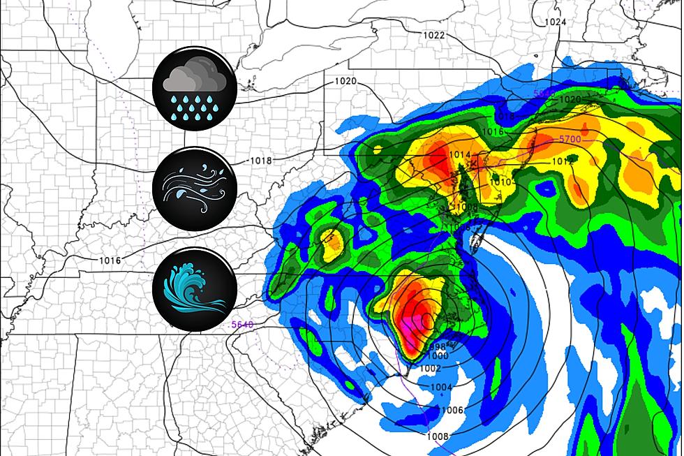
Coastal Storm: Timeline
Note: The Atlantic Ocean is already getting rough, as the coastal low deepens off the coast of Florida and Georgia.
Wave heights increase to about 5 feet on Thursday, peaking at 8 feet over the weekend. A high risk of rip currents blankets the Jersey Shore for the duration.
I don't think initial raindrops will enter South Jersey until around sunset Friday evening, around 7 or 8 p.m. Rain will spread north and become steadier overnight, probably overtaking the entire state by daybreak Saturday morning.
Saturday morning looks nasty, as heavy rain and strong winds drive through New Jersey. Everybody in the state probably gets soaked, although the worst weather will likely be to the south and east.
There should be some lulls in the rain Saturday afternoon. But it will stay windy and damp and cloudy and miserably cool. High temperatures will struggle to reach the 60s.
Latest model guidance shows a new, unfortunate scenario that keeps this area of low pressure stalled over NJ for another day or more. That means rain will fill in again Saturday night through at least Sunday morning.
I do not see a high potential for heavy rain after about Noon on Sunday, and winds should start to calm. Having said that, scattered showers and a strong breeze may continue through Sunday afternoon and evening. There's even a chance for rain lasting until Monday morning before finally clearing out.
Coastal Storm: Impacts
No weather forecast is complete without a measure of "confidence" — how certain the forecaster is that a scenario will play out as described. Right now, I'd call my forecast confidence "moderate". There's going to be a storm. It's going to get wet and windy. But the details are still a bit shaky — when will the rain exit, how much rain will fall (and how quickly), and how hard will the winds blow.
Let me lay out some numbers for the storm's potential impacts:
—Rain... Most likely rainfall totals will range from about an inch to the northwest to 2-3+ inches to the southeast. Periods of torrential rain could lead to flash flooding, especially along low-lying areas and roadways. At least one forecast model still keeps totals much lower, around a quarter-inch (inland) to an inch (coast). And some estimates do go as high as 4 or 5 inches — that is a lot of rain.
—Wind... I estimate wind gusts will max out around 30 mph for most of the state, with 40+ mph gusts along the coast. Not quite "tropical storm" criteria, and not enough to do widespread damage. But it could make driving and walking difficult, downed tree branches may cause power outages, and wind-driven rain will cause even more visibility issues.
—Severe Weather... As the center of this strong area of low pressure passes directly over New Jersey Saturday evening, there is an increased chance for thunder and lightning, strong thunderstorm cells, and even a tornado or two. A lot depends on the precise track of that circulation center, but this is something we will have to watch.
—Waves... As I mentioned above, wave heights will grow to about 5 feet on Thursday, surging to 8 feet on Friday. Dangerous rip currents are likely and beach erosion is possible.
—Coastal Flooding... Luckily, this storm falls in the middle of the lunar cycle, which puts us at a relatively low astronomical tide. Still, the persistent east-northeast wind will drive some water toward our coastline. Probably enough for a couple rounds of minor category flooding along tidal waterways.
After the Storm
Again, I can't guarantee dry weather prevails until about midday Monday. And even then, a prevailing on-shore breeze will keep temperatures unseasonably cool and skies less than stellar next week.
For now, I will say Monday, Tuesday, and Wednesday will feature a mix of sun and clouds with high temperatures approaching 70 degrees.
Our next frontal boundary storm system will come into view in the Wednesday-Thursday time frame, with our next chance of rain.
TIPS: Here's how you can prepare for power outages
Dan Zarrow is Chief Meteorologist for Townsquare Media New Jersey. Follow him on Facebook for the latest forecast and realtime weather updates.