
New year, new active weather pattern: Two snow chances for NJ
UPDATE... This article is outdated...
For the latest storm forecast information, please refer to my newest weather blog post.
The Bottom Line
For the first time in forever, New Jersey has a legitimate shot of snow in the forecast. It is at the tail-end of the 5 Day Forecast, in the Saturday night to Sunday time frame.
As excitement (and hype) builds, it is important to stay grounded in reality — it is still way too early to talk about confident timing or accumulation details.
Winter storms are complicated, because they can cause multiple severe impacts. They are finicky, as a small change to the timing or track can yield a dramatically different outcome. And they can be highly impactful, wreaking havoc on the comings and goings of New Jerseyans far and wide.
That is why I always play out these forecasts slowly and conservatively. We will talk about scenarios here and through Wednesday, then fill-in more critical details Thursday and Friday. If there are alarm bells to ring, I promise you will know about it.
(Keep reading for more on what we currently know and what we do not regarding this weekend's potential storm.)
In the meantime, quiet weather will carry through midweek. There is another storm system set to dive south of New Jersey, which could spark some "conversational" snow showers Thursday morning. 'Tis the season!

Tuesday
It's a big back-to-work and back-to-school day. And all's quiet in New Jersey's weather world. We are starting this Tuesday morning with temperatures around 30 degrees. High temperatures Tuesday afternoon will reach the lower 40s or so. Typical chilly January weather.
Skies will be mostly sunny, although I could see some fair-weather clouds build later on. Expect a light northwesterly breeze and dry weather, from start to finish.
Tuesday night will be uneventful too. Clouds will roll in late. And temperatures will be cold, again bottoming out near 30. A freeze for most of the state.
Wednesday
Still nothing noteworthy to talk about. With periods of sun and clouds, Wednesday will be another dry weather day. High temperatures will push upward slightly, into the mid 40s.
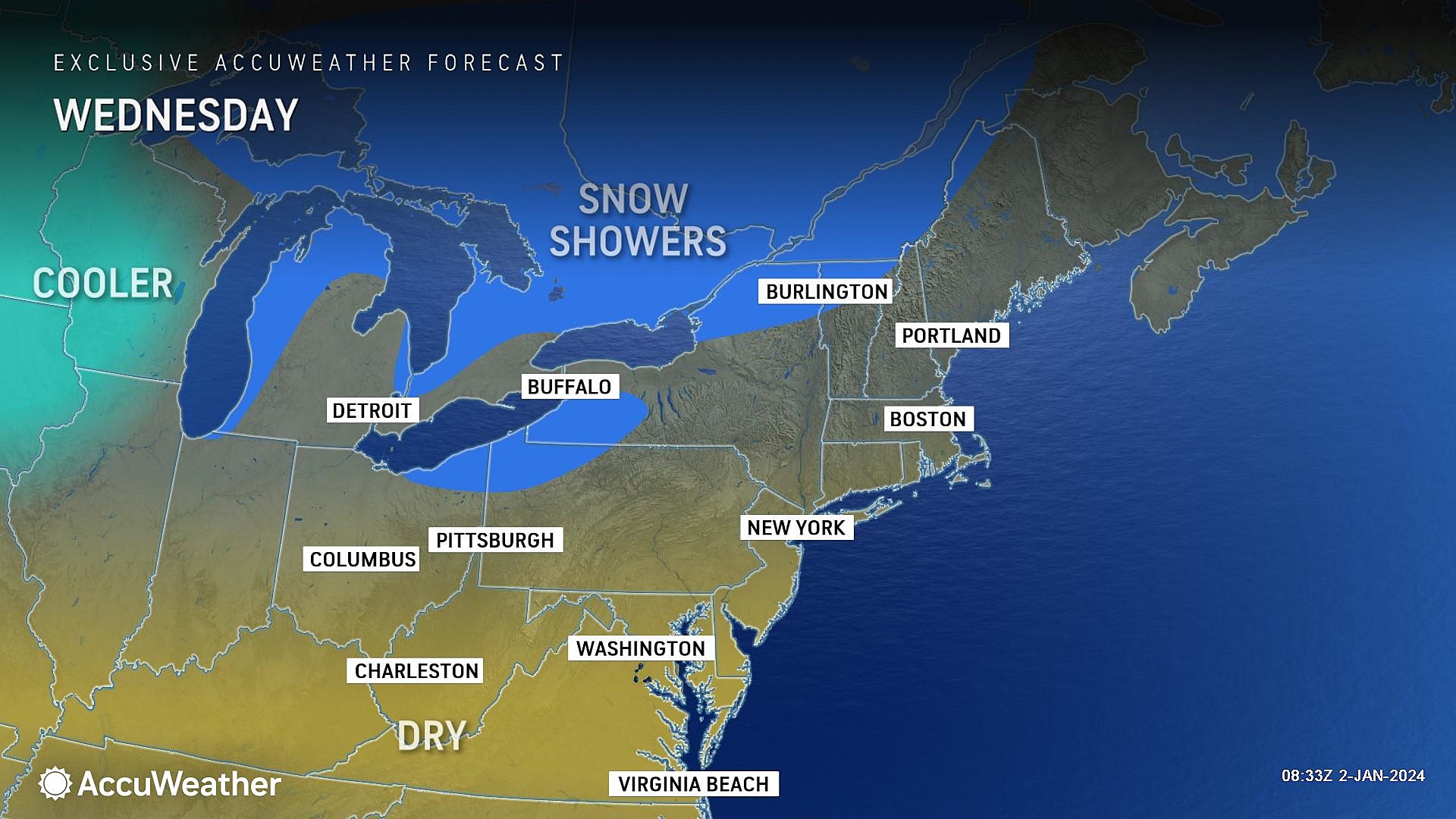
Thursday
Early Thursday morning, a storm system will be diving south of New Jersey. Moderate rain is likely from the Carolinas on south. However, it may creep close enough for a brief shower to clip the Garden State. And given the early morning timing, that would most likely be a snow shower. Given the track of the main area of low pressure, the best chance for snowflakes (or raindrops) would be southern New Jersey.
Out of an abundance of caution, I will say that a dusting or coating is possible on the ground somewhere in NJ early Thursday. But significant accumulations or travel impacts are highly unlikely. That is why I am comfortable calling this only "conversational" snow.
The rest of Thursday will be breezy and blustery, with wind gusts possibly hitting 30 mph. That chilly breeze (behind a cold front) will spark a slow cooldown too. Highs on Thursday will scale back to the lower 40s. Skies will gradually transition from clouds to sun too.
Friday
Friday will be quiet, but cold. Look for mostly sunny skies. But temperatures will start the day in the 20s, only warming into the upper 30s Friday afternoon.
The Weekend & Beyond
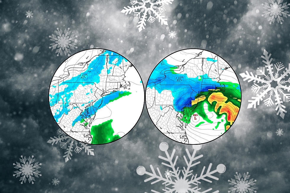
Here's where things get interesting. As a potent storm system — a nor'easter — approaches New Jersey from the south-southwest, cold air will be in place to the north-northwest. That combination is the ticket for wintry weather, including the potential for moderate to heavy snow accumulations.
Let's run through what we do know at this point, with about 100 hours until onset:
—Hit or miss? Five days out, we can usually make a "hit or miss" call, whether a storm is worth watching or steering away. I just don't see a complete "escape route" at this point — I have reasonably high confidence that yes, there will be a storm in New Jersey this weekend.
—Major storm? Having said that, this setup does not look like a snow bomb, an epic storm of biblical proportions, etc. (Fill in whatever hype-ish descriptions you want here.)
—Snow or no? I amcomfortable calling this New Jersey's best shot at widespread accumulating snow in almost two years.
—Rain to snow. But it will not be an all snow situation for all of New Jersey. Rain and wintry mix could be dominant precipitation types, especially to the south and along the coast, before a potential transition to all snow.
—The brunt. It looks like the brunt of the storm, with the potential for the heaviest snow/rain and biggest impacts, will be Saturday night to early Sunday morning. So mainly during the overnight hours.
—Snowfall potential. Forecast models have suggested double-digit snowfall totals (10+ inches) are possible in the "all snow" zone in NW NJ.
—Rainfall potential. On the other hand, if this storm leans toward a warmer, rainier solution, rainfall totals of 1 to 2 inches would be likely.
—Coastal impacts. The "coastal storm" or "nor'easter" moniker conveys the east-northeast wind that will accompany the storm. Wind, coastal flooding, and beach erosion are possible. (Although again, I do not think it will be a "blockbuster" storm necessarily.) Something to watch closely.
Here's what we don't know, details and question marks that we look forward to filling in soon:
—Exact timing. Over the past day, the storm's timeline has shifted notably earlier, now arriving Saturday evening. And it's totally possible it shifts again, in either direction, as model guidance gets a firmer handle on the speed and track of the center of low pressure. In my opinion, the timeline for first flakes, transition from rain to snow, brunt of the storm, and last flakes is the most important piece of the forecast.
—Snow accumulations. Snowfall of 0 to 12+ inches is on the table right now. Literally anyone in (inland) NJ could fall anywhere in that range. Once the storm track becomes more certain, we will have a better feel for the geography of the rain-snow line. And that will ultimately dictate how much snow falls and accumulates.
—Icing potential. I do not think there is a tremendous sleet or freezing rain threat, although the rain-to-snow transition to the southeast could lead to some icing. Something else to watch.
—Travel impacts on Sunday. I could spit out accumulation numbers all day, but it says nothing about the on-the-ground impacts for New Jerseyans who have places to go during the storm Saturday night and/or after the storm on Sunday. Or even Monday. Road conditions will be heavily impacted by all the timing and accumulation factors I have already laid out here.
Here is how our coverage will play out in the coming days:
—Wednesday. As the storm's timing and potential impacts firm up, we will likely focus on some possible scenarios. That will let you start to plan your weekend, based on how snowy (or rainy or not) it will be in your corner of New Jersey.
—Thursday and Friday. Dialing in the details. First snowfall forecast map of the season will probably come out sometime on Thursday. Refining those numbers and the timeline of the storm into Friday.
—Saturday and Sunday. It's all about the play-by-play. We'll have one more shot at nailing down the forecast Saturday morning. Then we transition to live on-air and online coverage as the snowflakes (and raindrops) fall.
It is also worth mentioning that long-range models are picking up on another significant storm around the middle of next week, Tuesday to Wednesday. At the moment, it looks like a rainmaker, carrying warmer air up from the south as it arrives. But that is far from a sure bet. And I have to wonder what kind of flooding potential comes from heavy rain and rapid snowmelt on top of snow-blocked storm drains.
Let it snow: 12 things to know about winter forecasting in NJ
Gallery Credit: Dan Zarrow
Dan Zarrow is Chief Meteorologist for Townsquare Media New Jersey. Follow him on Facebook for the latest forecast and realtime weather updates.
Glossary of NJ winter weather words and phrases
Gallery Credit: Dan Zarrow