A temperature roller coaster for NJ: From frigid teens to warm 70s
The Bottom Line
Cooling down, then warming up. A "wavy" temperature forecast is a classic sign of late winter and early spring. The transition between seasons is never gentle and smooth — it always happens in leaps and spurts. So it should not be too surprising that we have both temperatures in the teens and the 70s in the forecast over the next few days.
Thursday will be cool. Friday will be cold. Saturday turns more seasonable. Sunday and Monday will be downright warm. But raindrops will play an important part in the forecast for early next week too.
Thursday
A weak clipper system and associated cold front sparked some early morning rain. And that rainfall became pretty heavy for a short time around the I-78 and I-287 corridors. As of this writing (5:30 a.m.), we're just about done with raindrops. Spotty showers will remain possible through mid-morning, around 8 a.m.
Morning clouds will give way to sunshine by Thursday afternoon. It is a "cold front day," so we have to talk about some wind and the arrival of colder, drier air. Wind speeds will end up firmly in the "breezy" range, with occasional gusts over 20 mph, blowing out of the northwest.
Morning temperatures are fairly mild, in the 40s. I expect thermometers to dip a bit through midday, before recovering to the mid 40s by late afternoon. (It's one of those days where I can't call that the "high" temperature, since it was technically warmer at 12:01 a.m.)
So not a bad afternoon. Just breezy and definitely cooler than Wednesday's 50s.
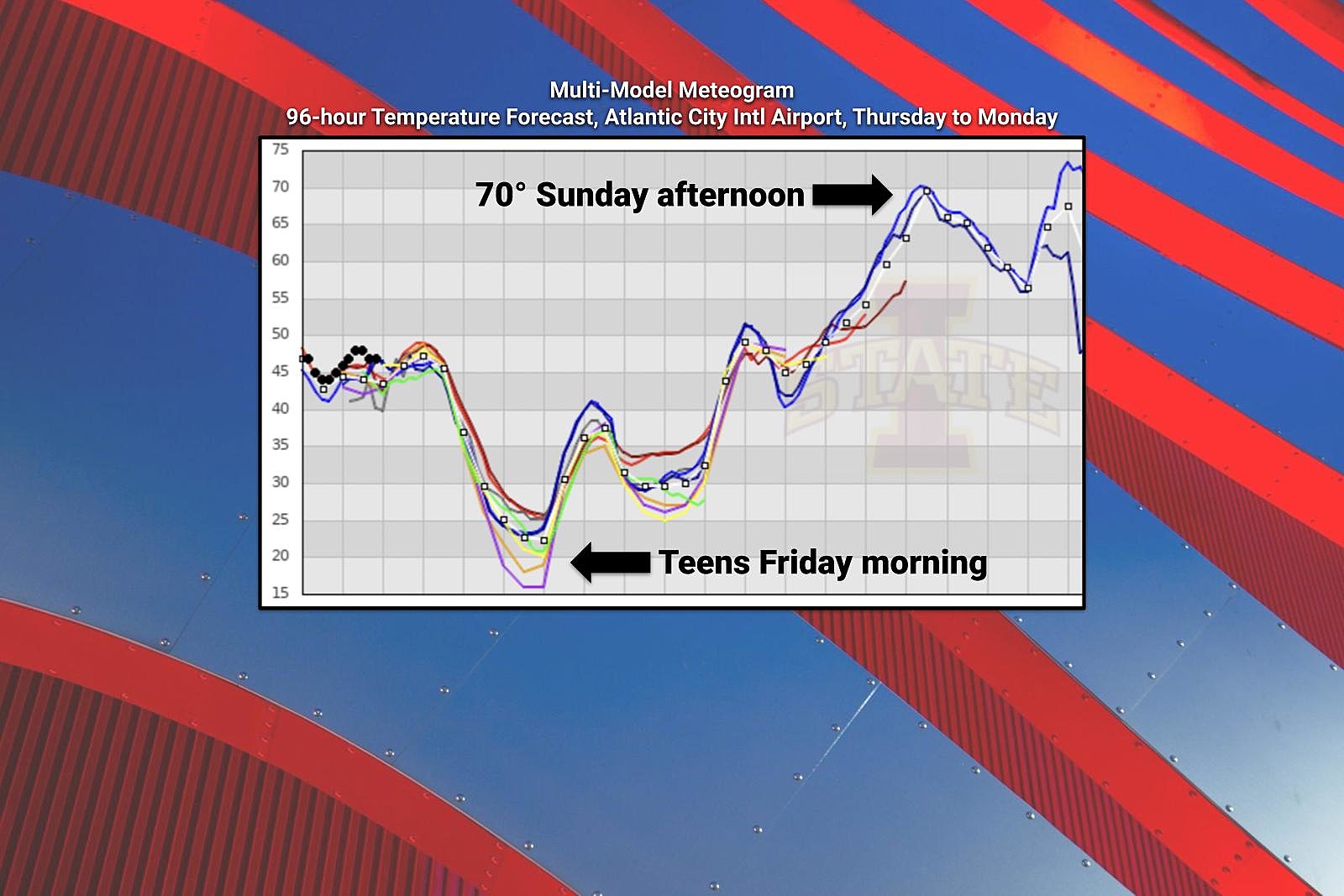
Thursday night looks frigid. Once the wind calms down, temperatures will tank. We'll end up around 20 degrees (give or take) by Friday morning. Any little breeze will bite, pushing the wind chill (the "feels like" temperature) closer to 10 degrees.
Friday
Bundle up! It's going to be a mid-winter-ish kind of day. At least this "bottom of the barrel" cold only lasts one day.
Highs on Friday will only reach the mid 30s. That is about 10 degrees below normal for early March. Skies will be sunny, weather will stay dry, and winds will be considerably lighter than Thursday.
Some clouds will roll in Friday night. That will prevent temperatures from crashing too far. It will still be a freeze for most of the state, with lows in the 20s. There could be flurries flying around through early Saturday morning too.
Saturday
Heading into the first weekend of March, and we have some big improvements on the way.
Saturday will be more seasonable, with most high temperatures across the state coming within a few degrees of 50. Skies will be mostly cloudy. Some models are pushing out spotty sprinkles during the day, but I've opted for a dry forecast for now.
Sunday
Warm! Temperatures will soar well into the 60s, with 70+ a possibility in South Jersey. That is a full 20 degrees warmer than Saturday. And a full 20+ degrees above normal for this time of year. (Record highs are in jeopardy.)
It's not a perfect forecast though. Our weather will turn cloudy and breezy on Sunday. And the warm front driving the temperature increase could spark some showers during the daytime hours on Sunday.
Monday & Beyond
We'll have one more shot at 70+ in South Jersey on Monday. Meanwhile, to the north, we'll start to taste our next push of cooler air.
Our next widespread storm system is set to arrive Monday afternoon, driving steady to heavy rain through Tuesday morning. Some forecast models are really pumping out some solid rainfall, in excess of 2 inches across a swath of New Jersey. We really could use the rain, so it's all good. Given the warmth, there could be some embedded rumbles of thunder. (I'm seeing a huge flooding or severe wind threat, but that possibility will be worth watching.)
So we'll be cooling down again through the middle of next week. 50s on Tuesday. Seasonable 40s on Wednesday.
As we've discussed previously, our next opportunity for any kind of wintry weather won't be until late next week. 10-day forecasts — which rarely have a shred of accuracy — do show a rain-to-snow situation for next weekend. But there's plenty of time for that forecast to change and evolve.
Dan Zarrow is Chief Meteorologist for Townsquare Media New Jersey. Follow him on Facebook or Twitter for the latest forecast and realtime weather updates.
2022 Seaside Heights Polar Bear Plunge photos
Gallery Credit: Andrew Miller/For Townsquare Media NJ
Don't get fooled: Here's 25 scam texts I received in just one month
Gallery Credit: Mike Brant
More From Beach Radio