Wild pre-Christmas weather for NJ: 6 impacts you need to know about
UPDATE... This article is outdated...
For the latest winter storm forecast information, please refer to my newest weather blog post.
UPDATE as of 4 p.m. Wednesday...
ORIGINAL POST from 11:12 a.m. Wednesday...
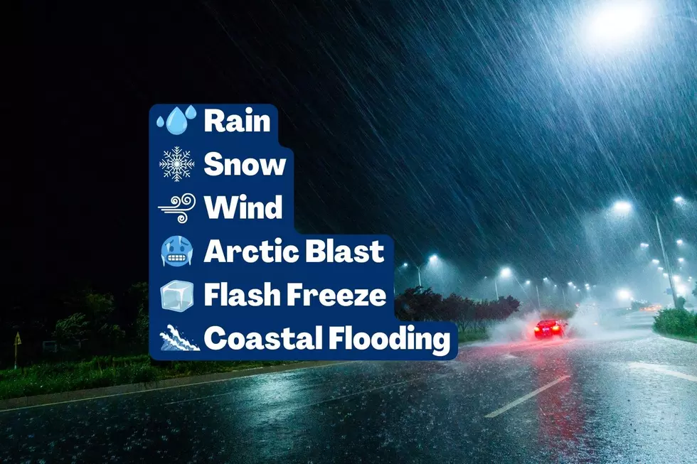
From rain to snow, fierce winds to tumbling temps, a flash freeze to coastal flooding, we face significant travel disruptions across New Jersey (and much of the country) this holiday season.
Let's run through an outline of what nastiness is coming our way, when it will arrive and depart, and how it may affect your holiday travel plans.

Rain
--The Bottom Line... Everyone in New Jersey will get soaked by wind-driven rain, with the heaviest stuff arriving Thursday night.
--Thursday Morning... Spotty showers may creep into southwestern New Jersey, but they will be light and hit-or-miss.
--Thursday Afternoon... Rain becomes steadier and more widespread, encompassing most (if not all) of NJ by mid-afternoon.
--Thursday Night... Brunt of the storm. Bands of heavy rain will cause visibility and traction issues.
--Friday... We should catch a lull in the rainfall right around daybreak Friday morning. Then, ahead of our inevitable cold front, one more band of rain (and possibly snow) will shove through the Garden State from about mid-morning through midday. Once again, there is a potential for some downpours.
--Total Rainfall... Models have scaled by on the rainfall potential, with most of the state ending up between 1 and 2 inches. The farther north you are, the more rain you're likely to see.
--Impacts... Ponding and flash flooding could become an issue during heavy rain, especially if fallen autumn leaves block storm drains. Drivers may need to slow down considerably due to slippery roads and reduced visibility. There will almost certainly be flight delays due to the poor weather too.
Snow
--The Bottom Line... The wintry weather potential is very limited from this storm. But definitely worth mentioning.
--Timing... As the "grand finale" line of precipitation rolls from west to east across New Jersey Friday morning, cold air will be knocking on our door too. If temperatures drop quickly enough - especially about a mile over our heads - a brief, but potent, period of snow is possible.
--Total Snowfall... Even though the ground will be wet (due to rain) and warm (due to temperatures in the 50s), it may snow hard enough for a healthy coating of accumulation. (Forecast models go as high as an inch.) Best chance for that - and slippery spots - will be in colder NW NJ.
--Impacts... The transition from warm-and-wet to cold-and-wintry will be very sudden and highly impactful. There is a chance of snow severely restricting visibility, and causing icy road conditions. (Keep in mind, crews will not be able to pretreat roads, due to the extended period of rain.) Be extra aware of changing weather and road conditions, and pack your patience. Once again, this threat of wintry weather will probably impact flight delays and cancellations too.
Wind
--The Bottom Line... With a powerful storm system and a deep pool of arctic air in play, there will be two opportunities for fierce wind gusts through the rest of the week.
--Timing (Part 1)... During Thursday night's heavy rain.
--Timing (Part 2)... After the cold front Friday.
--Top Wind Gusts... 40 mph (inland) to 50 mph (coast). I'd wager the strongest winds will blow late Friday, as arctic air "whooshes" into New Jersey.
--Impacts... As I mentioned above, wind-driven rain (and snow) can significantly reduce visibility and make for "just plain nasty" weather conditions. Driving high-profile vehicles can be very difficult in such gusts, and commercial vehicles may be restricted on area bridges. And yes, flight delays are likely, as strong winds necessitate spacing out airport arrivals and departures for safety.
Arctic Blast
--The Bottom Line... Quite possibly the most noticeable and longest-lasting impact of this week's wild weather. As we taste truly arctic air for this first time this season, temperatures across all of New Jersey will drop 30+ degrees over the course of a few hours Friday afternoon.
--Thursday to Early Friday... Well above freezing, mainly in the 50s. Possibly approaching 60 degrees along NJ's southern coast. That's why this storm system is primarily wet, not wintry.
--Friday Afternoon... As a cold front pushes through, arctic air will arrive in New Jersey, sending thermometers tumbling. We'll go from 50s to 20s within just 3 to 6 hours on Friday.
--The Christmas Weekend... Things stay frigid for the weekend, setting up one of the coldest Christmas holidays in decades here in the Garden State. Morning low temperatures will be in the singles and teens. Highs will not rise out of the 20s. We will probably be stuck below freezing continuously from 3 p.m. Friday through next Wednesday afternoon - a full 120 hours!
--Wind Chills... The combination of extreme cold and high wind is never a good one. By Saturday morning (Christmas Eve morning), the wind chill may dip below zero for several hours. Remember the wind chill is not just the "feels like" temperature - it is an important indicator of the human health impacts of cold and wind. Anything below zero is "the danger zone" - you really have to bundle up warmly and take care of yourself in that kind of truly arctic weather.
Flash Freeze
--The Bottom Line... With the sharp drop in temperatures comes another potential issue. After an inch or two of rain, there will be an abundance of puddles and wet surfaces across New Jersey. Temperatures may fall so hard and so far that they freeze rapidly to solid ice, making for a slippery and truly treacherous situation. And again, pretreatment with salt and brine is impossible - this is the kind of "perfect storm" setup that leads to huge pileups on major highways, which ice over suddenly.
--Timing... Temperatures are forecast to drop below 32 degrees by mid to late Friday afternoon, likely settling in the teens by Midnight. (I'd say things could get treacherous after about 2 p.m.) Unfortunately, the most perilous time period for subfreezing temperatures will coincide with the big holiday getaway Friday afternoon and evening.
--Action Steps... Travel early or late if you can. Stay extra aware of the rapidly changing temperature, road conditions, and traffic conditions.
Coastal Flooding
--The Bottom Line... As if this weather isn't messy enough, tidal guidance is showing one round of significant flooding of tidal waterways coming up Friday morning.
--Timing... Only one high tide cycle is a concern for now, occurring after the brunt of the storm's rainfall early Friday morning. High tide will occur around 6-7 a.m. on the oceanfront, 2 to 4 hours later on back bays and tributaries, and 6 to 8 hours later up the Delaware River.
--Magniture... About two feet of storm surge will cause widespread minor to moderate flooding of tidal waterways. There is one tide gauge forecast - at Sandy Hook - that comes just two inches from major flood stage. That is
--Action Steps... Forecasting coastal flooding is finicky = the exact orientation of the wind and the beaches are important factors in determining just how high those tidal levels go. We will continue to monitor this piece of the forecast very carefully. In the meantime, Jersey Shore residents should plan for moderate category water inundation - move cars to higher ground if necessary, expect road closures, and secure boats/docks/etc. accordingly.
Final Thoughts
This storm system is not exactly a "winter storm" for New Jersey. (Even though in other parts of the country, it will dump a foot of snow with blizzard conditions.) But there are multiple severe, potentially dangerous impacts in play. And with Christmas coming up, this is an incredibly busy traveling week.
It is time to make appropriate plans for the nasty weather ahead. Consider any travel plans carefully. Dress appropriately for the weather - especially important for Friday, the big temperature drop day. Stay extra alert to changing weather and road conditions.
And, of course, stay tuned here for your latest weather, traffic, and news updates before, during, and after the storm.
Dan Zarrow is Chief Meteorologist for Townsquare Media New Jersey. Follow him on Facebook or Twitter for the latest forecast and realtime weather updates.
Christmas snow - When it's happened, and the 2024 odds for NJ
Gallery Credit: Mike Brant
Light Up New Jersey: Best holiday displays of 2022
Gallery Credit: Light Up NJ — Vote here
Let it snow: 12 things to know about winter forecasting in NJ
Gallery Credit: Dan Zarrow
More From Beach Radio