Tuesday NJ weather: Heat, humidity, and a few strong thunderstorms
UPDATE as of 3:45 p.m. Tuesday...
ORIGINAL POST from 7:18 a.m. Tuesday...
The Bottom Line
The headline says it all. Tuesday's forecast is what summertime in New Jersey is all about. Heat. Humidity. And stormy weather.
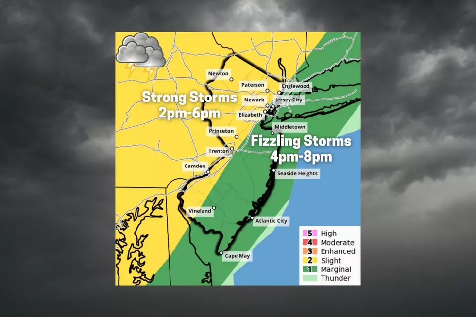
Tuesday's thunderstorm threat is not a "slam dunk". It is not necessarily going to rain everywhere in New Jersey. The risk of severe weather is clearly greatest to the north and west, as storms will weaken significantly as they approach the coast. However, I think it's still a very good idea to keep an eye on the sky Tuesday afternoon and evening, no matter where you are.
While Tuesday will be a steamy day, humidity and temperatures will take a (small) step backward on Wednesday. We'll mix very warm weather with occasional unsettled conditions. Some showers will clip NJ on Thursday. And then clouds and rain could become a problem over the weekend too.

Tuesday
A good morning, a hot day, and a (somewhat) stormy finish.
We're starting the day with temperatures in the 60s. Pretty comfortable, although noticeably 10 degrees warmer than Monday morning.
Air conditioners will be running on full blast Tuesday, as high temperatures aim for 90 degrees almost pretty much the entire state. We'll start the day mostly sunny, with an increasing southwesterly breeze. Humidity will ramp up through the afternoon too, as dew points push into the 70s.
Might be a little hot and buggy at the beaches. And the posted rip current risk is moderate to high.
The threat for thunderstorms will begin in northwestern New Jersey around 2 or 3 p.m. And given our juicy atmosphere, those first few hours could turn pretty violent. Especially along and northwest of the NJ Turnpike.
The full gamut of thunderstorm impacts is on the table here: Heavy rain, gusty winds, frequent lightning, hail, and even a tornado. We will be lacking a few ingredients for widespread severe weather. (Moisture flow isn't all that rich, low-level jet is not that strong, and the timing isn't perfect.)

And again, those storms will be scattered. Broken apart. Not everyone will see a storm.
In addition, as scattered thunderstorms drift to the east and south through Tuesday evening, those storms should weaken significantly as they approach the coast. Shore counties could start to see raindrops around the evening rush hour / dinnertime.
We should largely dry out and start to clear out by Midnight. It will remain somewhat sticky overnight, with low temperatures in the lower 70s.
Wednesday
Through the rest of the week, New Jersey will ride a tightrope between humid/tropical air and dry/comfortable air. That's not a terrible place to be.
Wednesday's weather looks dry. It will be partly sunny, leaning more toward "blue" than "grey". And still very warm, with high temperatures around 85 to 90 degrees.
Dew points will settle around 60 on Wednesday. Not steamy and suffocating.
Thursday
Our next bout of unsettled weather will come on Thursday. But once again, don't expect a widespread soaking.
In fact, it looks like we only face about two rounds of showers. One in the morning, mainly to the south. And another late-day Thursday, mainly northern and central NJ.
In between, it will be mostly cloudy Thursday. High temperatures will come down a little bit. Look for mid to upper 80s.
Friday
A weak cold front will cool temperatures a few more degrees. But the numbers still look seasonably warm for Friday, in the lower to mid 80s.
I'm seeing a mix of clouds and sun. And I have opted for a dry forecast for now.
The Extended Forecast
The midpoint of July is coming up, and so we are firmly entrenched in the "dog days of summer". I have two concerns for the upcoming weekend.
First is a storm system parked off the coast, keeping predominantly on-shore winds on top of us. (Blowing from the northeast on Saturday and the southeast on Sunday.) That presents the chance for cloud cover, especially along the coast. And cooler-than-normal temperatures, likely around 80 degrees (give or take).
The second potential issue is a return to unsettled, occasionally wet weather for Sunday into Monday. While much of New Jersey could use a healthy soaking right about now, it could significantly affect outdoor plans.
Forecast confidence is shaky at best by the end of the weekend. So we'll have to wait another couple of days to piece together more specific details on timing, temperatures, totals, etc.
Dan Zarrow is Chief Meteorologist for Townsquare Media New Jersey. Follow him on Facebook or Twitter for the latest forecast and realtime weather updates.
BEEP BEEP BEEP: These are the 13 types of Wireless Emergency Alerts auto-pushed to your phone
Gallery Credit: Dan Zarrow
11 reasons why storm chasing in NJ is a very, very bad idea
Gallery Credit: Dan Zarrow
More From Beach Radio