Thursday NJ weather: Brighter, drier, friendlier skies
The Bottom Line
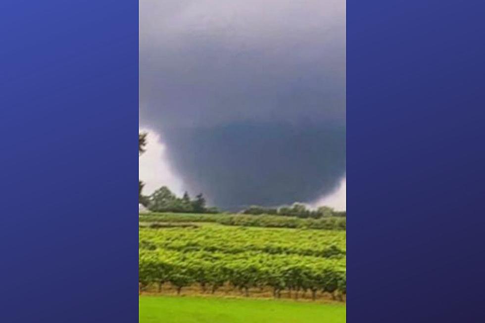
Wow, what a night. The remnants of Ida wreaked havoc on New Jersey overnight, with incredible rainfall totals up to 12 inches, widespread flooding, and one or two tornadoes. As the sun rises Thursday, many New Jerseyans will survey the damage and reflect on a truly historic weather event.
The most impressive statistic I've seen so far? Newark Airport recorded 8.41 inches of rain through Midnight. That smashes the previous record for calendar day rainfall - 6.73 inches on November 8, 1977.
The rain departed between Midnight and 3 a.m. So areas of flash flooding ("giant puddles" on roadways and other low-lying areas) have already seen some improvements.
However, river flooding will continue to be a huge concern Thursday. Numerous flood warnings remain in effect, as some of NJ's biggest rivers (the Raritan, the Passaic, the Delaware, etc.) haven't quite crested yet. The latest flood guidance shows major flooding along most of those major waterways. River levels along the Raritan River in particular could rival the historic, record crests during Floyd (1999) and Irene (2011).
Behind Ida, we will get to enjoy some beautiful, almost fall-ish weather. Our next chance of rain won't come along until Sunday, several days away. That's more good news, as we won't have to deal with a resurgence of flooding on our super-saturated ground and swollen waterways.
Thursday
There are three impacts from Ida left for Thursday. The residual flooding and river crests, of course. It's also going to be breezy through the morning, with some gusts along the coast up to 30 mph. And finally, the Atlantic Ocean will get stirred up a little bit. 1 to 3 foot waves and an elevated risk of rip currents will accompany very localized minor coastal flooding at high tide.
Weatherwise, it's going to turn into a beautiful day. Sunshine will break out across New Jersey by around mid-morning. It will be completely dry going forward too. High temperatures will only reach the lower to mid 70s - that is 5 to 10 degrees below normal for this time of year.
Friday
Another beautiful day. No air conditioning required. Mostly sunny, with highs in the lower 70s.
Saturday
We begin the Labor Day Weekend with a continuation of pleasant conditions. (NW NJ could see some early morning low temperatures in the upper 40s!)
Most of the state looks partly sunny on Saturday, with highs in the mid 70s.
Sunday
Two hiccups will impact Sunday's weather.
The first, an increase in humidity, as dew points rise into the mid 60s. So it will feel somewhat stickier.
And the second, a storm system will slide from west to east across New Jersey Sunday morning, dragging through some rain showers. These raindrops look pretty limited in terms of intensity and duration. And before they arrive, our ground and waterways will have a chance to dry out substantially. So it's just going to be some wet weather - not a resurgence of flooding issues.
The Extended Forecast
Labor Day Monday will bring a return to warm 80s. It should be a pleasant, summer-ish end to the holiday weekend.
I don't see any major concerns in the near future. We are approaching the average peak of the Atlantic hurricane season. There is one storm way out there - Hurricane Larry. But it does not pose an imminent threat to the U.S. East Coast at this time.
I hope you and your loved ones are safe and sane, after this incredibly serious weather storm. We'll continue to bring you the latest on Ida's aftermath, both on-air and online.
Dan Zarrow is Chief Meteorologist for Townsquare Media New Jersey. Follow him on Facebook or Twitter for the latest forecast and realtime weather updates.
Hurricane Ida damage in New Orleans & The Gulf Coast
BEEP BEEP BEEP: These are the 13 types of Wireless Emergency Alerts auto-pushed to your phone
Remembering Tropical Storm Irene's impact on NJ, 10 years later
More From Beach Radio