Steamy, stormy weather for NJ: Flash Flood Watch, Heat Advisory
Steamy, stormy weather for NJ: Flash Flood Watch, Heat Advisory
Humidity will be New Jersey's main weather feature this week, fueling soupy, uncomfortable days and some super soaker thunderstorms.

The Bottom Line
Humidity will be New Jersey's primary weather feature this week. It will not only fuel soup, uncomfortable days, but also some super soaker thunderstorms. It is summertime, after all.
If all goes well, we'll get some relief from the steaminess on Thursday. But the heat rolls on.
There's no significant tropical activity in the Atlantic at this time.
Monday
We begin the new week with a warm front in the neighborhood. That thermal boundary will serve two purposes in this weather forecast: 1.) Cause a pretty big gradient in temperatures and sky cover between northern and southern New Jersey, and 2.) Serve as a spark for spotty to scattered thunderstorms.
After some noisy thunderstorms in North Jersey overnight, there's one more batch of rain hanging over NE PA as of this writing (5:30 p.m.) That could produce a brief period of rain across North Jersey (above I-78) through 8 or 9 a.m.
Meanwhile, dew points will be firmly in the 70s for the next few days, leading to sticky, steamy conditions. Look for temperatures in the 70s early on. And highs will hit about 85 to 90 degrees for most of the state. Far North Jersey and the Jersey Shore will end up cooler, closer to the 80-degree mark. Skies will average partly sunny across the state.
A Heat Advisory is in effect from 11 a.m. to 8 p.m. Monday for part of the Philadelphia metro area in southwestern New Jersey. This advisory includes northwestern Burlington, Camden, and Gloucester counties. The heat index ("feels like" or "apparent" temperature) may hit 102 degrees.
Starting around 2 p.m., we'll be watching northern and central New Jersey for super soaker thunderstorms to develop. Since the atmosphere is like a sponge right now, chock full of moisture, pockets of heavy rain are likely.
Someone in NJ will probably get 2+ inches of rain Monday afternoon through evening. Given how saturated the ground is already, that can quickly lead to flooding issues.
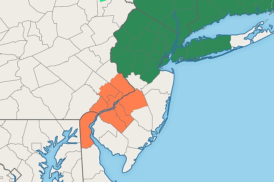
A Flash Flood Watch has been issued for the 11 northernmost counties in New Jersey: Middlesex, Somerset, Hunterdon, Warren, Morris, Sussex, Passaic, Bergen, Hudson, Essex, and Union. That watch runs from Monday afternoon through early Tuesday morning.
I wouldn't rule out a shower or thunderstorm drifting south of that watch area. But I think the geography there is pretty spot on.
Any threat of heavy rain will fade after Midnight Monday night. The rest of the overnight will be mostly cloudy and muggy, with low temperatures only dipping into the lower 70s.
Tuesday
Less unsettled and stormy, but still very humid.
In North Jersey, clouds will win the sky, limiting high temperatures to the mid 70s to around 80.
In South Jersey, mostly sunny skies will continue, allowing temps to soar to the upper 80s to around 90.
An isolated shower or thunderstorm may pop up Tuesday afternoon, but I believe most of NJ will remain dry.
Wednesday
One more steamy day, with highs settling in the mid 80s across most of the state. (It could be another 90+ degree day to the south.)
Scattered clouds are expected Wednesday morning. And then a cold front arriving from the west could fire off a line of strong thunderstorms in the afternoon. (Not all forecast models paint a stormy picture - but I can't imagine this frontal passage staying dry, given the rich moisture in the atmosphere.)
Thursday
We finally get a break from the humidity, as dew points descend to about 60 degrees. (Pretty good for this time of year.)
But it'll still be hot. Highs on Thursday will come very close to 90 degrees, especially in urban areas and inland South Jersey.
It should be a partly sunny, rain-free day.
The Extended Forecast
For Friday, Saturday, and Sunday, it looks like we'll face temperatures at or above seasonal normals (mid 80s). Plus, a daily chance of spot thunderstorms. I don't want to go into more detail than that - we'll dive deeper into the weekend outlook once the midweek cold front picture gets clearer.
Dan Zarrow is Chief Meteorologist for Townsquare Media New Jersey. Follow him on Facebook or Twitter for the latest forecast and realtime weather updates.
Can You Name These NJ Beaches?
More From Beach Radio