Snow bomb to drop on NJ Thursday morning: 6+ inches in 6+ hours
Snow will pour out of the sky during Thursday's morning drive, over an inch an hour at times. A Winter Storm Warning remains in effect for most of NJ.
A Significant, Unusual Storm
Yes, we hit 70 degrees in South Jersey on Wednesday. And yes, we're still expecting a big snowstorm less than 12 hours later.
Temperatures will tumble sharply Wednesday evening, thanks to a cold front slipping across the Garden State. Our incoming winter storm is a shortwave, a compact storm system that will ride along this cold front. Not a "nor'easter" and not a "blizzard," but it's going to produce some incredibly heavy snowfall for a large swath of New Jersey (and points further north).
North Jersey (at least) is expected to fall below freezing by the time our snow storm's first bands arrive, just after Midnight. While precipitation may begin as rain in Central Jersey, it will quickly transition to sleet and snow. The only place in the state where precipitation type will significantly hinder snow totals will be the south coast (Atlantic, Cape May, and Cumberland counties).
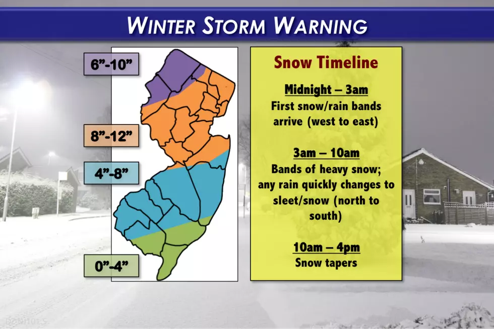
Since Wednesday morning's forecast update, I've generally bumped snow totals upward, for all but far northern and far southern New Jersey. See the latest forecast map above, or my text description below for the details.
I can not stress enough how hard it's going to snow, at a very poor time, during the morning rush hour. 1 to 2 inches of snow per hour will cause near-zero visibility within the heaviest snow bands. The snow will also pile up very quickly, causing travel conditions to deteriorate steadily as daybreak passes.
Warning and Advisory
A Winter Storm Warning has been issued for 18 of New Jersey's 21 counties:
--Midnight to 6 p.m. Thursday for Bergen, Essex, Hudson, Passaic, and Union counties.
--Midnight to 4 p.m. Thursday for Hunterdon, Mercer, Middlesex, western Monmouth, Morris, Somerset, Sussex, and Warren counties.
--4 a.m. to 4 p.m. Thursday for Burlington, Camden, Gloucester, eastern Monmouth, Ocean, and Salem counties.
A less severe, less urgent Winter Weather Advisory has been issued for:
--8 a.m. to 2 p.m. Thursday for Atlantic, Cape May, and Cumberland counties.
Timeline
Between Midnight and 3 a.m. Thursday, bands of snow will arrive generally from southwest to northeast. Precipitation intensity will ramp up very quickly.
Central Jersey (generally below the Route 1 corridor) may see rain at first. As temperatures continue to drop, rain will change over to sleet and snow very quickly.
"Prime time" for this winter storm will be between 3 a.m. and 10 a.m. Thursday. That's when snowfall rates may exceed an inch per hour.
After 10 a.m. Thursday, snowfall intensity will decrease significantly. However, light to moderate snow could continue to make travel difficult through early afternoon.
Snow will be all done and skies will begin to clear across New Jersey by about 4 p.m. Thursday.
Totals
The sweet spot for this storm will be a large swath of northern and central New Jersey, where 8 to 12 inches of snow is expected to fall.
Far northern New Jersey, around Sussex and Warren counties, may end up falling out of the heaviest snow bands. So I've tempered the snow forecast accordingly, in the 6 to 10 inch range.
Further south, I still believe that rain and wintry mix will interfere with snow accumulations. So, from the Turnpike/I-295 corridor of SW NJ over to Ocean and southern Monmouth, our forecast calls for 4 to 8 inches of snow accumulation.
The south coast continues to be a conundrum, and I still sense it's going to be a "boom or bust" ordeal. From far southern Ocean County through Atlantic, Cape May, and Cumberland counties, we'll see either hardly anything or upwards of 4 inches of snow on the ground by the end of the day.
Coastal Concerns?
I haven't really mentioned coastal concerns with this storm... Because there really are none - this is not a coastal storm. Guidance suggests 6 foot waves and 1 to 1.5 foot surge will be possible. No significant flooding or erosion issues are expected.
Confidence/Limiting Factors
Sigh. What a headache of a forecast. But I am reasonably comfortable with this "final" forecast. That means I believe there are equal chances of this forecast busting "too high" and "too low".
On one hand, it's "just" a shortwave, usually an innocuous storm system type that doesn't carry much "oomph". Plus, let's not forget that it was 70 degrees on Wednesday, which could limit how quickly snow will stick and accumulate.
On the other hand, the severe temperature drop could contribute to intense strengthen and even higher snow totals - some forecast model runs have suggested over a foot of snow in spots. The biggest number I've seen? 19 inches in North Jersey. Believing raw model output like this is dangerous and foolish, given the amount of assumption and estimation regarding snow ratios and snowfall rates that are contained in such numbers. It's also important to note snow totals are much more reasonable in the afternoon run, with nothing showing up above a foot (in NJ, at least).
Final Words
So here we go, jumping into the biggest snowstorm of the season! As always, I'll remind you to stay SMART and be SAFE.
One piece of good news regarding this storm's poor timing? Our top-notch morning show team will be all over the heavy snowfall as it's happening. You can expect live updates from me, both on-air and online, throughout the morning.
Next forecast blog will be published during the peak of the storm, to be posted by about 7 a.m. Wednesday.
More From Beach Radio


