Slow weather improvements Friday, as nor’easter exits NJ
UPDATE... This article is outdated...
For the latest winter storm forecast information, please refer to my newest weather blog post.
The Bottom Line
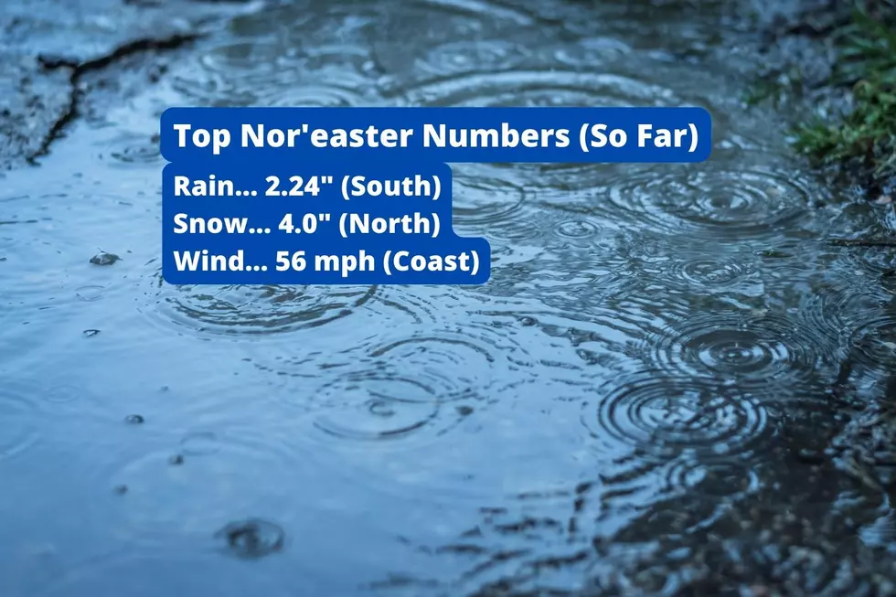
As promised, Thursday was a downright disgusting day. Over 2 inches of rain in South Jersey. About 3 inches of snow in North Jersey. Wind gusts to 50 mph along the Jersey Shore.
Friday will be better. But still inclement, as our nor'easter slowly departs to the northeast. Raindrops will linger through much of the day, especially to the north and east. Winds will slowly decrease, but it will stay breezy (at least). We also have one more precarious high tide cycle coming up Friday afternoon.
Our weather clears out and dries out for the weekend, although temperatures will be on the chilly side. The quiet trend will continue through the first half of next week.
Friday
As of this writing (6 a.m.), there is only one area of solid rain left along the Jersey Shore. For the most part, we just have spotty showers and sprinkles and mist and fog around. It's a damp start to the day.
So it will not be as nasty, but we'll still find scattered raindrops around. South Jersey has already started to dry out. Central Jersey and the Shore could see showers into the afternoon. And rain will be slow to exit in North Jersey, possibly not until the evening hours. Additional rainfall will range from a trace (south) to a quarter-inch (north).
The threat of wintry weather is minimal going forward. Rain may mix with some snowflakes and ice pellets at times, but only along the northern edge of NJ. Little to no additional accumulation is expected.
Meanwhile, it's still pretty windy. The biggest gusts are behind us now. But the anemometer may still push over 30 mph at times Friday morning. We'll descend into the "breezy" category Friday afternoon, with occasional gusts over 20 mph.
Those easterly wind gusts have pushed a marginal amount of ocean water toward the Jersey Shore too. Last night, tidal water levels crested above flood stage. And I am concerned about one more round of coastal flooding Friday afternoon. Widespread minor category flooding is possible, especially for Ocean and Monmouth coastal communities.
Temperatures Friday morning have risen to close to 50 degrees (outside of "wintry" NW NJ). Thermometers will gradually slide backward through Friday afternoon. I suspect we will end up close to 40 degrees by sunset.
Skies will finally clear Friday night, as the coastal storm system races off to the northeast. Temperatures will not drop cold enough fast enough to worry about a "flash freeze". We'll see lows around in the freezing mark, in the lower 30s.
Saturday
A much brighter, happier day to kick off fall's final weekend. I'm going to call Saturday mostly sunny, although some extra clouds may come into play as the day presses on. Winds will be lighter, but still noticeable. And we stay completely dry — a nice change of place.
High temperatures should reach into the lower 40s, just slightly below normal for this time of year. So all in all, it will be a decent December day.
Sunday
Sunday will be the colder of the two weekend days. Solidly in the 20s in the morning. And highs will get stuck in the upper 30s for all but NJ's southern coast. Again, rain-free and snow-free, under partly sunny skies.
The Extended Forecast
Nothing dramatic for early next week, as dry but chilly weather continues.
Monday will feature increased cloud cover and a stiff breeze. High temperatures will make it to around 40 degrees. Temps will be close to that mark on Tuesday and Wednesday too. The Winter Solstice occurs on Wednesday at 4:47 p.m.
Our next weathermaker is taking shape for late next week, in the Thursday-Friday time frame. And oh boy, the hype train has already sped out of the station on this one. Could we really get buried in snow just before the Christmas holiday?
Well, you know my answer to that. It's too early to give a definitive answer. Especially since forecast models have been extraordinarily shaky in the 6 to 7 day range so far this season.
However, I will say the setup looks interesting. If the storm track is right, and if temperatures stay cold enough? Sure we could see significant snow. For at least part of the state. And that could lead to some major travel headaches as we're talking about the 22nd and 23rd of December.
But let's wait a bit before we start taking this one seriously. By the end of the weekend, we'll look to make a "go-no go" call, then dialing in timeline and impacts through Monday, Tuesday, and Wednesday.
Until then, I hope you enjoy the last weekend before Christmas.
Dan Zarrow is Chief Meteorologist for Townsquare Media New Jersey. Follow him on Facebook or Twitter for the latest forecast and realtime weather updates.
Light Up New Jersey: Best holiday displays of 2022
Gallery Credit: Light Up NJ — Vote here
A list of NJ malls where you can get photos with Santa for the 2024 holiday season
Gallery Credit: Mike Brant
More From Beach Radio