Remnants of Ida: Latest timeline, rain totals, and flooding impacts for NJ
UPDATE... This article is outdated...
For the latest storm forecast information, please refer to my newest weather blog post.
UPDATE as of 2:15 p.m. Tuesday...
Afternoon models are in. And there's still a clear consensus keeping the heaviest 5+ rain totals (and biggest flooding threat) over the northern half of the state. As we've discussed, that means the greatest tornado risk will be in southern NJ (along with 1+ inch of rain).
The timing has changed a bit. We'll still see a few "appetizer" bands of rain during the day tomorrow.
Latest guidance suggests the "brunt" of the storm will push in a bit earlier (7 p.m. Wednesday), and also clears out the nasty weather sooner (5 a.m. Thursday).
ORIGINAL POST from 6:48 a.m. Tuesday...
The Bottom Line
Hopefully by now you've heard that the remnants of Hurricane Ida will bring some nasty weather to New Jersey in the coming days. It will not be a hurricane or tropical storm when it gets here. (It's already become extra-tropical.) But we are almost certainly facing heavy rain, flooding, severe weather, and even a bit of storm surge. The brunt of the storm will arrive late Wednesday night.

For this update, I've tried to keep length explanations and graphics to a minimum. I just want to focus on "need to know" info that everyone is asking about.
Where is Ida now?
What was once a major hurricane has now become "extra tropical" or "post tropical". That means the area of low pressure (storm system or disturbance) is no longer "feeding" on the warm ocean. It is now behaving more like an inland, continental, mid-latitude cyclone.
As of 5 a.m., the Ida's remnants were moving from Mississippi and Alabama into Tennessee. It's made very slow forward progress over the last 24 hours. But it will pick up speed as it turns toward the northeast, following a frontal boundary right toward New Jersey.
Why is this still a challenging forecast?
The precise storm track is still shaky. And that can have a huge impact on "who sees what".
Ida's timeline is pretty much locked in. And we're now pretty confident about the degree of magnitude for potential impacts too. It's just a matter of geography — where the bullseye will end up.
Models have flip-flopped back-and-forth, pushing the center of Ida's remnant low through northern and then southern New Jersey. I'm following along a general consensus of the heaviest rain falling along northern and central New Jersey. That would put the greatest risk of severe or tornadic thunderstorms in central and southern New Jersey. If anything, that notion would drift south — putting heavy rain over central and southern NJ, and the risk of tornadoes south of us.
Any issues for Tuesday?
Nothing big. We're not under the thumb of Ida's remnants just yet. Although what happens Tuesday will set the stage for its arrival.
It's a muggy morning across New Jersey, with temperatures around the 70 degree mark. And we'll see highs in the warm lower to mid 80s Tuesday afternoon. Skies will stay mostly cloudy.
A cold front will slowly sag across New Jersey, potentially driving in a few rain showers through the afternoon and evening hours. Humidity levels will also knock back a bit for all but the southern coast — dew points in the 60s will be much more comfortable than the 70s.
The chance of rain will slowly increase Tuesday night, especially toward daybreak. Overnight lows should fall into the almost-seasonable upper 60s.
When will Ida arrive?
Initial rain bands will impact NJ during the daytime hours Wednesday.
We'll see pockets of scattered rain throughout the day. There will be some breaks. Along with some embedded thunderstorms and downpours. It looks like a pretty soggy and dreary day overall.
High temperatures on Wednesday will range from the upper 60s (north) to upper 70s (south).
When will Ida peak?
Late Wednesday night through Thursday morning. That's when you'll want to hunker down, as the nastiest, wettest weather blows through
To be more specific, I'd put heavy rain over most of New Jersey starting as early as 10 p.m. Wednesday evening. And it should exit as late as 10 a.m. Thursday morning (possibly, hopefully much earlier).
The strongest winds and highest risk of severe weather (including an isolated tornado or two) will accompany the center of the storm system, early Thursday morning.
When will Ida depart?
On the drier back half of the storm, we should see big improvements by Thursday late morning. And I fully expect the sun to pop out by Thursday afternoon.
What will be NJ's biggest impact from Ida?
Rain and flooding. Specifically, flash flooding, river flooding, inland flooding, freshwater flooding. A whole lot of water accumulating in a short period of time.
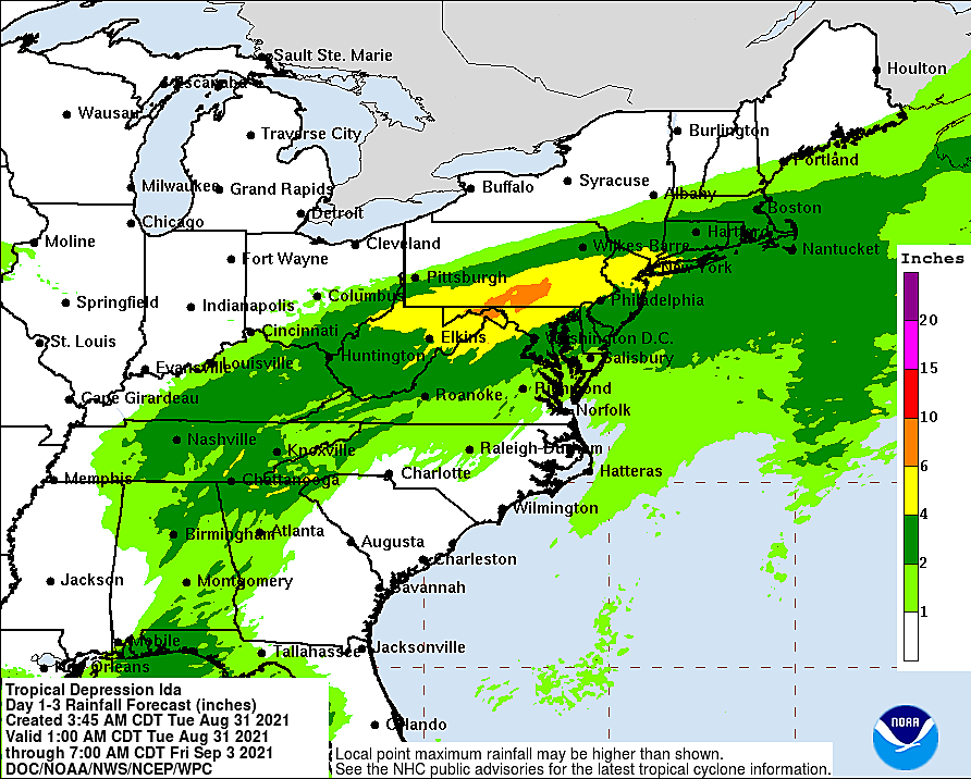
I still favor a forecast of 3 to 6+ inches for a wide swath of NJ. (Again, at the moment, the rain bullseye looks like northern to central NJ, especially between I-195 and I-80. But that's not a guarantee.) The "plus" is very important, as locally heavier rainfall is possible due to tropical rain bands and/or training thunderstorms.
With the impacts of Tropical Storm Henri still fresh in our mind from two weeks ago, the question must be asked: Could we see another 200-year storm, and another wave of dramatic, evacuation-inducing, property-damaging flooding? I have to admit it is possible. The ground is still pretty saturated. And waterways are still running high, although below flood stage. The National Weather Service has smartly pointed out the Passaic River and Raritan River basins would be most susceptible to water rise due to heavy rainfall.
A Flash Flood Watch has been issued for all 21 counties of New Jersey in advance of Ida's remnants. For most of the state, that watch covers 8 a.m. Wednesday through 8 p.m. Thursday. For the five counties in northeastern NJ (Bergen, Essex, Hudson, Passaic, Union), the watch technically runs from 2 p.m. Wednesday through 2 p.m. Thursday.
What's our second biggest concern?
Severe weather. Specifically, tornadoes.
Atmospheric parameters are coming together, suggesting a couple of quick spin-ups are possible as the center of Ida's remnant low passes overhead. (The most important indicator here is wind shear, which occurs when wind blows at different speeds or directions at different heights in the atmosphere.)
Because the greatest risk of a severe or tornadic thunderstorm will be found in the moist southeastern quadrant of the storm, southern New Jersey would be most under the gun for this aspect of stormy weather.
What's our third most significant issue?
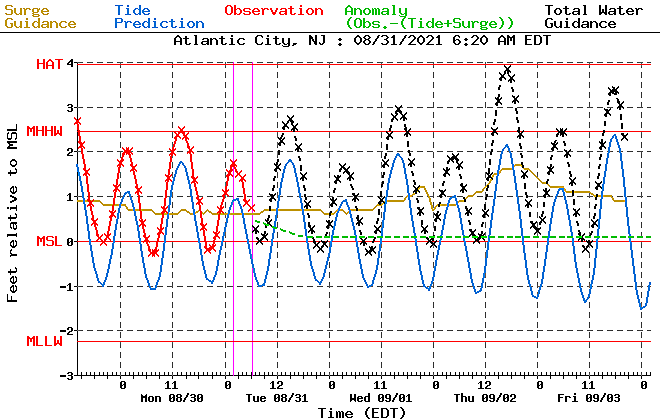
Storm surge and coastal flooding.
I'm actually surprised how bull-ish tidal guidance is. A foot or two of storm surge is being predicted, especially for coastal communities with more of a southern exposure (Atlantic, Cape May, and Cumberland counties.) Those models show a foot or two of water rise, which is enough to cause widespread minor to localized moderate category flooding at high tide.
The biggest tide crest looks to be at the tail end of the storm on Thursday.
Anything else?
Some wind.
Again, not hurricane or even tropical storm strength. But some gusts in the 40-50 mph neighborhood are possible. And, especially when combined with heavy rain, that does raise a risk for power outages Thursday morning.
What's next?
There is a light at the end of the tunnel! Beautiful weather will immediately follow Ida's departure.
Friday looks mostly sunny, dry, and comfortable. High temperatures in the mid 70s would be 5 to 10 degrees below normal.
Saturday should be quite pleasant too. Partly sunny and again mid 70s.
There will be some rain chances associated with a cold front Sunday into Labor Day Monday. (Of course, it's only appropriate that we see a rain chance for the 14th and final summer weekend in a row.)
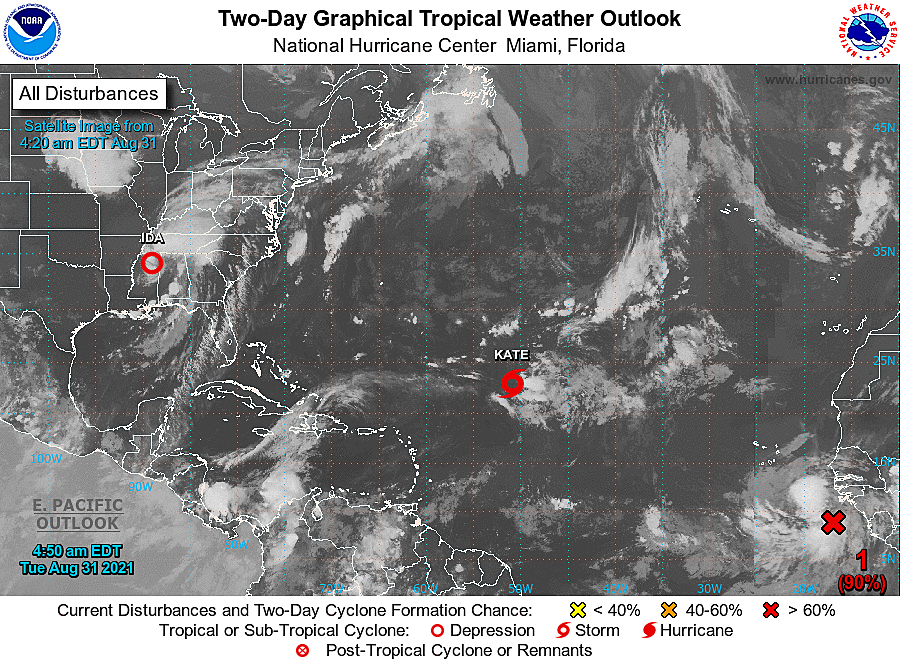
Meanwhile, the Atlantic basin remains active. Julian is long gone. Tropical Storm Kate is meandering in the middle of the ocean, and is not expected to impact the U.S. East Coast. Another strong tropical wave just ejected from the west coast of Africa. That one may become Larry in the next day or two.
Dan Zarrow is Chief Meteorologist for Townsquare Media New Jersey. Follow him on Facebook or Twitter for the latest forecast and realtime weather updates.
Remembering Tropical Storm Irene's impact on NJ, 10 years later
Census 2020: The 20 biggest places in New Jersey
More From Beach Radio