

NJ’s weather turns unsettled, as clouds and April showers return
Sigh, all good things must come to an end. After two days of truly incredible spring weather, our forecast now turns unsettled for the foreseeable future. That means a series of storm systems will drive persistent clouds and regular rain chances through the Garden State.
For Thursday, we'll see a few batches of rain showers throughout the day. Nothing incredibly organized, it will be here-and-there, hit-or-miss — it's certainly not going to rain all day. The most widespread rain activity is likely to push through the state around Thursday afternoon into the early evening hours. Skies will be mostly cloudy and temperatures cooler than the past few days. High temperatures should remain below 65 degrees.
While Thursday night looks mainly dry, I can't rule out some showers in the evening hours and then sprinkles and patchy fog overnight. Temperatures will fall to comfortably cool levels, in the lower 50s or so.
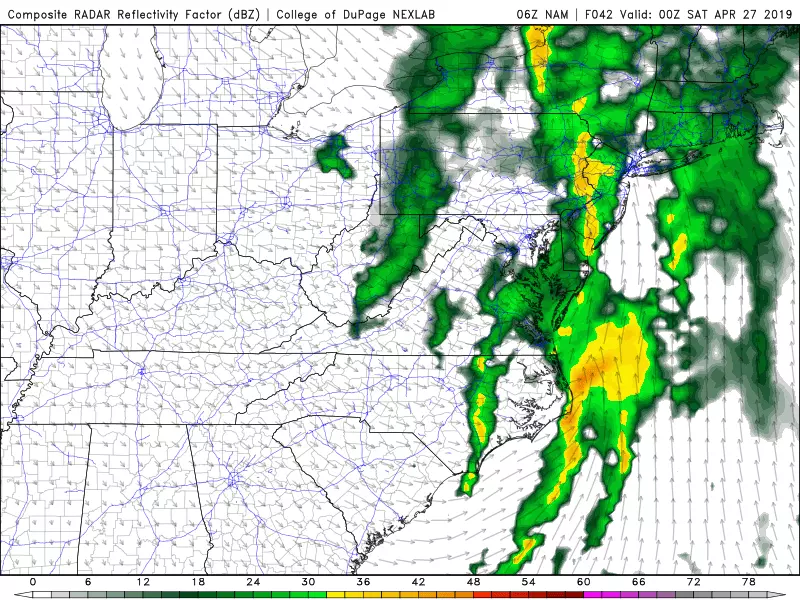
Friday will be our wettest day of the week, but it's still not a total washout. You'll need the umbrella to battle against scattered light rain Friday morning. Then, through the middle of the day, you might catch patches of dry weather and even peeks of sunshine. That sunshine will push temperatures back to around the 70 degree mark. (It will likely be even warmer in SW NJ.) However, the warmth and sunshine are not necessarily a good thing — as the atmosphere warms and destabilizes, providing extra "oomph" for the day's final round of rain Friday evening (around dinnertime). That raises the potential for heavier rain and strong thunderstorms.
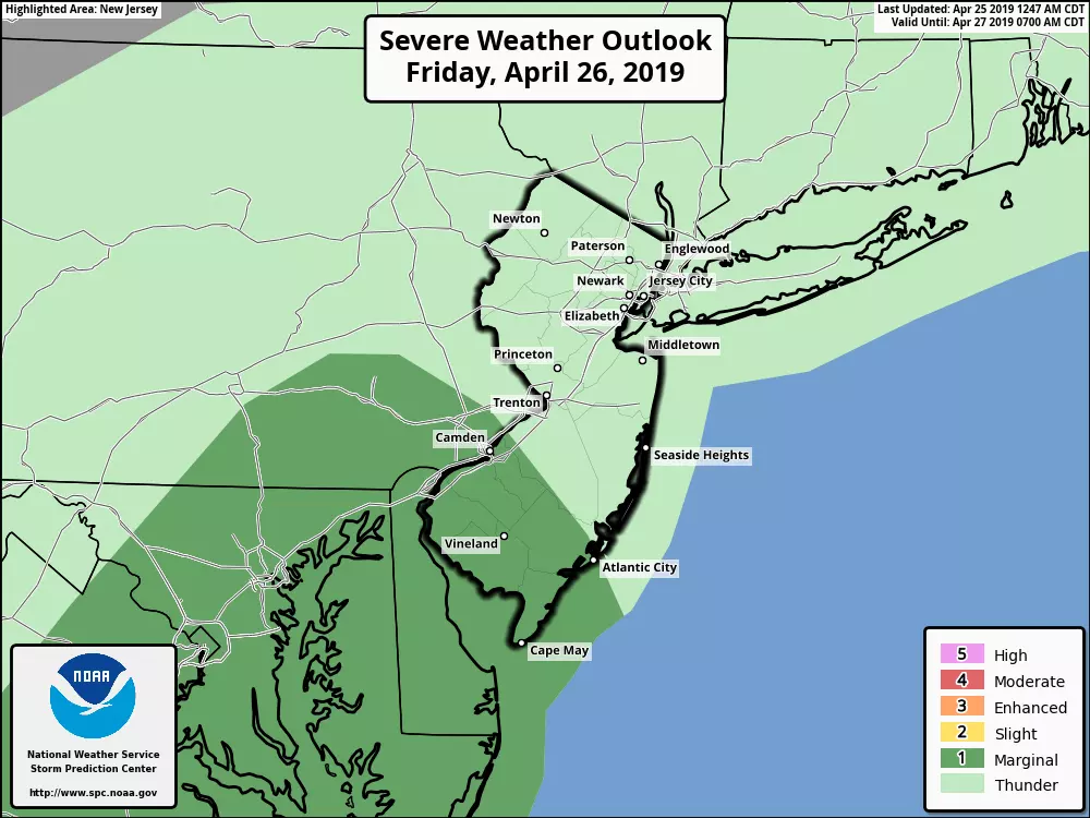
The Storm Prediction Center has painted southwestern New Jersey in a "marginal risk" for severe weather on Friday. While everyone in New Jersey could experience thunderstorms late Friday, it makes sense that the warmest corner of the state has the highest threat for strong to severe storms. (That equates to a 5% chance of 60+ mph winds, by the way.)
As a cold front will from west to east across the state late Friday evening (around 10 p.m.), putting an abrupt end to the rain and thunderstorms.
Our new air mass will lead to a mostly sunny day Saturday. Temperatures should end up ever-so-slightly below-normal, in the lower 60s. While the sunshine and dry weather will be nice, I fear the wind will be a nuisance throughout Saturday too — gusts to 40 mph are possible.
Models have settled on a solution for Sunday that pushes another batch of clouds and showers through the state. I don't want to pinpoint the timing and intensity too much — this forecast is really a muddled mess! The combination of rain, clouds, and an on-shore wind component will lead to even cooler temperatures. Part of New Jersey may be stuck in the 50s at best to end the weekend.
While Monday looks dry, much of next week also looks unsettled. It seems abundant cloud cover and April showers will gave way to... May showers too.
More From Beach Radio


