NJ weather: Falling into fall with thunderstorms and a big cooldown
The Bottom Line
Happy first day of fall, New Jersey! The autumnal equinox officially occurs at 9:04 p.m. Thursday. And the new season will arrive alongside a new, cool, very dry air mass. That strong cold front will spark a period of wet, stormy weather across the state on Thursday. And then temperatures tumble deep into "jacket weather" territory for Thursday night and Friday.
Temperatures will moderate heading into the final weekend of September. Meanwhile, we have our eyes on the tropics. Fiona is about to tear up the coast with big waves. And another threat in the Caribbean Sea is definitely one to watch.

Thursday
A strong cold front will be the spark for our big weather transition. And will make for a not-nice day across New Jersey.
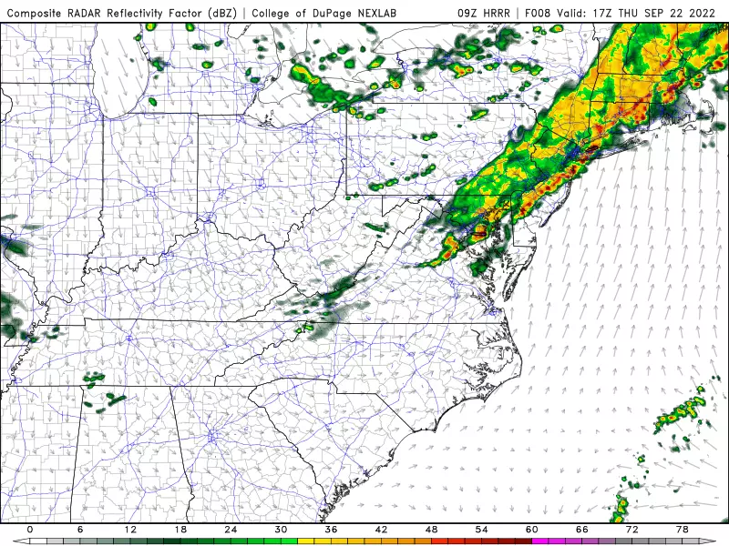
As of this writing (6:30 a.m.), thunderstorms are just now arriving in NW NJ. So pockets of rain will push through northern New Jersey Thursday morning. Those scattered storms will trend toward reach the NJ Turnpike corridor through the midday hours. And then South Jersey will get wet Thursday afternoon.
Everyone in the state will probably see about 3 to 6 hours worth of wet, stormy weather during the daytime hours Thursday.
Within the band of relatively light rain, there are several stronger thunderstorm cells. Those are capable of producing brief downpours, gusty winds, and frequent lightning.
Before the rain, it will be mostly cloudy. High temperatures will range from the upper 60s (north) to 70s (most of the state) to around 80 (south).
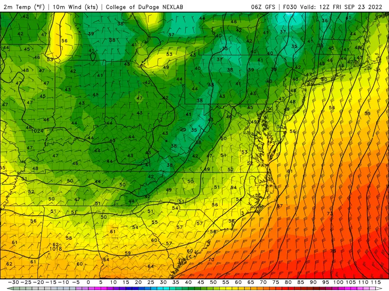
After the rain, a strong breeze will kick in, as chilly air "whooshes" in from the northwest. We should see substantially drier, clearer conditions by around dinnertime.
And then, as skies continue to clear Thursday night, temperatures will drop sharply. Overnight lows will dip into the upper 40s to lower 50s. Still breezy too.
Friday
Positively October-ish. Sunny skies. Very dry air. Cool temperatures. And windy conditions — northwest gusts may touch 30 mph throughout the day.
I usually call that combination of chilly wind "blustery". Definitely a jacket, sweater, or hoodie kind of day. (I'm sad the days of shorts and sandals will be behind us.)
High temperatures will only reach about 60 to 65 degrees. That is about 10 degrees below normal for late September. It will be New Jersey's coolest day since early May.
Friday night will get even colder. We'll see widespread 40s on the temperature map by Saturday morning. Maybe even some 30s in the northwest hills. I think we're safe from widespread frost, but patchy ice crystals can't be ruled out.
Saturday
Believe it or not, this will be the last weekend of September, And our weather forecast will turn a bit warmer and more comfortable.
Winds will be considerably lighter on Saturday. It will be partly sunny and rain-free. Dry air means temperatures should quickly warm out of the 40s to around 70 degrees for a high.
A nice autumn day.
Sunday
On Sunday, temps will return to above normal levels, peaking in the upper 70s. No humidity concerns. Although clouds will take over the sky.
In addition, I have to add a chance of showers to Sunday's forecast. Different models show different timings for potential raindrops — the mostly likely scenario would be Sunday afternoon. But any rain should be light and not steady, so your whole day will not be washed out.
The Extended Forecast
The final few days of autumn will be quite autumnal. Although an occasional shower is not impossible, sunshine should dominate next week. High temperatures will probably hover just below normal, in the upper 60s to lower 70s on a daily basis.
Tropical Troubles
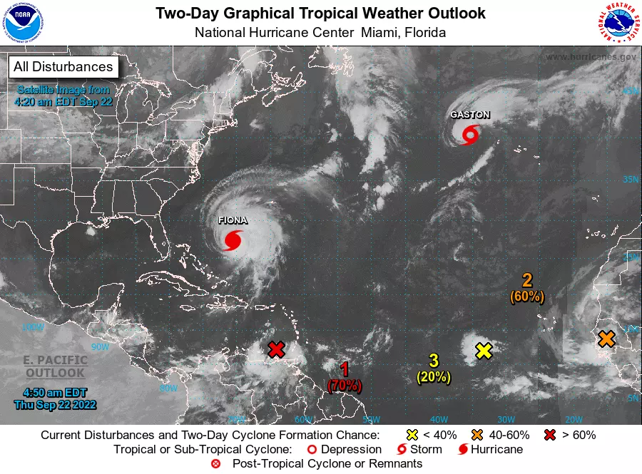
There are two tropical systems in the Atlantic basin that could have an impact on New Jersey.
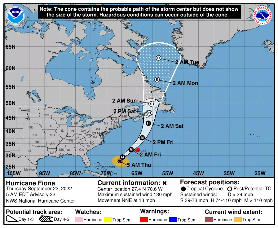
First is Fiona. Still a major hurricane with max winds of 130 mph, Fiona's center will pass just west of Bermuda early Friday morning. As it does, it will make its closest pass to New Jersey — 700 miles away, of course.
Fiona's powerful circulation is going to spit out some serious swell, leading to rough surf and big waves along the Jersey Shore. Our rip current risk will go from Moderate on Thursday to High on Friday. And the National Weather Service estimates 5 to 8 foot waves could be hitting our beaches during the peak on Friday. Although beach erosion is a concern, widespread tidal flooding is not.
In addition, a tropical wave that just entered the Caribbean Sea will likely become a tropical storm within the next day or two. The next name on the list is Hermine.
Most forecast models carry that system into the Gulf of Mexico in the next week. Some guidance shows it intensifying rapidly along the way.
Where that storm eventually goes next is a huge concern. Will the storm scrape across Florida or the southeastern U.S. and back out into the Atlantic, sliding up the coast? Will it instead make landfall farther west, closer to Texas or Louisiana, spreading a plume of tropical moisture our way?
We wouldn't see impacts from that potential storm for about 9 to 12 days — the beginning of October. That leaves plenty of time for this uncertain forecast to change. I just wanted to mention it here, so you're aware of it. And know that we'll be watching and tracking closely for the duration, as always.
Dan Zarrow is Chief Meteorologist for Townsquare Media New Jersey. Follow him on Facebook or Twitter for the latest forecast and realtime weather updates.
BEEP BEEP BEEP: These are the 13 types of Wireless Emergency Alerts auto-pushed to your phone
Each State in America and Their Favorite Type of Cereal...
Say you’re from Jersey without saying you’re from Jersey
More From Beach Radio