
NJ weather: Coastal flooding, some wind, some rain, and some icing
A powerful coastal storm — yes, you can still call it a nor'easter — is churning off the coast of the Carolinas on this Sunday morning. As it meanders north toward the Garden State, we have a smorgasbord of weather and surf issues to talk about. Most of those concerns are minor and geographically limited, but it's still important to be informed and prepared. (Especially if you're in NW or SE NJ — keep reading.)
We have some forecast developments since Saturday's special installment of the weather blog. Rather than bogging you down with the comprehensive sky-and-surf play-by-play, I'm just going to run through the important bullet points here.

Coastal Flooding
This storm's first precarious high tide cycle is coming up Sunday morning. High tide on the oceanfront will occur between 10 a.m. and 11 a.m. Back bays will crest as late as 2 p.m. About 1 to 1.5 feet of surge will produce minor to moderate flooding of tidal waterways.
The highest high tide is now expected to come Monday morning. (These forecasts are highly sensitive to the exact wind speed and direction.) Up to 2 feet of storm surge will produce widespread moderate flooding.
The biggest crests will be close to the magnitude of our last coastal storm in early October. You'll probably recall that one brought some pretty serious water inundation along the Jersey Shore. Meanwhile, ocean wave heights will build to 12 feet — beach erosion is likely.
Minor coastal flooding is also expected during Sunday evening's and Monday evening's high tide cycles.
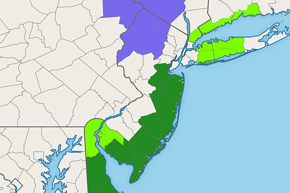
A Coastal Flood Warning has been issued from 8 a.m. Sunday through 5 p.m. Monday for almost the entire Jersey Shore, including Middlesex, Monmouth, Ocean, southeastern Burlington, Atlantic, Cape May, and Cumberland counties. A less-severe Coastal Flood Advisory covers Salem County from 11 a.m. Sunday to 4 p.m. Monday.
If your home or business is especially vulnerable to flooding, it's time to move your car to higher ground. As the tide rises, be sure to obey road closures, and never attempt to drive, walk, or swim through flooded areas. (It's very dangerous, and disgusting too.)
Some Wind
Saturday's top wind gust was 41 mph at Harvey Cedars on Long Beach Island. So far Sunday, we've had a few gusts of 30+ mph along the Jersey Shore. Coastal areas are once again facing wind gusts to 40 mph. It will be breezy for inland New Jersey on Sunday, with occasional bursts of 20+ mph wind.
Some Rain
As of early Sunday morning, showers have been lapping up against the Jersey Shore on the periphery of our coastal storm system. With temperatures in the 30s, I'm not surprised to have received some reports of light snow from Toms River to Atlantic City. However, no accumulation is expected. (Just watch out for slippery spots.)
Models have finally met on a strong consensus, and it is the mainly dry track I've been leaning toward for a few days. Scattered showers (mainly rain) are likely along the coast, with up to a quarter-inch of total rainfall — a damp day. Raindrops may occasionally stretch farther inland as the day goes on, with no more than a tenth of an inch of rainfall for most of NJ.
Steadier rain looks to come into play Monday into Tuesday, as the storm system makes its closest pass to New Jersey before spiraling out to sea.
Some Ice
While SE NJ deals with the potential for coastal flooding, NW NJ could see some wintry weather in the coming day or two. And it's not snow we're worried about here, it's ice.
There are two issues at play here. First, it is quite cold in North Jersey. As of this writing, temperatures are in the 20s — yet another hard freeze after a week of cold. The soil temperature at West Milford, Passaic County is down to 35 degrees. That primes the air and the ground for frozen precipitation.
Second important piece is timing. The "last licks" of this coastal storm system will swing through the state on Monday. If any piece of that occurs in the early morning or late night hours, when temperatures are coldest, we could see some wintry mix or freezing rain.
At most, we're talking about a light glaze of ice in the higher elevations of northwestern New Jersey only. Limited impacts, but still could make for some slick travel conditions on Monday.
A Winter Weather Advisory has been issued for Morris, western Passaic, Sussex, and Warren counties from Midnight to 10 a.m. Monday.
Bottom Line
Even though this coastal storm is pretty powerful, New Jersey will not see big, bad, direct impacts from it. Sunday and Monday will not be very nice weather days though. And the threats of coastal flooding and slippery spots can not be ignored.
Unless conditions change dramatically, my next weather blog will be published around 6 a.m. Monday. Have a safe and productive day!
Dan Zarrow is Chief Meteorologist for Townsquare Media New Jersey. Follow him on Facebook or Twitter for the latest forecast and realtime weather updates.
More From Beach Radio


