NJ weather: Another rain and wind maker at the end of the week
The Bottom Line
The highest rainfall totals in New Jersey from our almost-departed coastal storm topped 5 inches. The ground is thoroughly soaked, and rivers, streams, and creeks are still running high.
As we kick out one potent storm system Wednesday morning, we'll get almost 48 hours of dry, pleasant weather before we have to deal with the next one. Not a nor'easter this time around. And, by the numbers, impacts look lower. But it's still going to get stormy and nasty as we dive into the Halloween weekend.
Wednesday
As of this writing (5:30 a.m.), the center of that coastal low is passing Cape Cod, Massachusetts. The tail of the storm system is wagging over New Jersey on this Wednesday morning, driving one more wave of showers and drizzle from north the south through the state. So it's a damp (if not downright wet) start to the day.
Come mid-morning (8 or 9 a.m.), final raindrops will shove off the coast. And the rest of the day looks just fine. It will be breezy through about midday, with wind gusts to about 30 mph possible.
Skies will clear into Wednesday afternoon. The western half of NJ should turn mostly sunny. I'm not sure how much sunshine the Shore will see, but it should be bright, dry, and pleasant.
High temperatures will push into the lower to mid 60s. (Just how warm it gets will be a direct function of how much sun breaks out.)
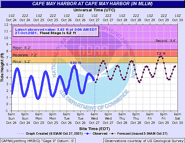
A Coastal Flood Advisory is in effect for NJ's southern coast, as a round of minor tidal flooding is expected. High tide on the oceanfront will be around midday, with back bays cresting into the afternoon.
The combination of mainly clear skies, calming winds, and dry air will contribute to a chilly Wednesday night. Low temperatures will dip mainly into the mid 40s. It may end up a few degrees colder in NW NJ and the Pine Barrens. However, a widespread frost/freeze is not expected.
Thursday
Not bad, but definitely feeling like fall. Skies will progress from early sunshine to afternoon clouds. Even so, we'll stay dry during the daytime hours. High temperatures will end up close to 60 degrees, just shy of late October normals.
Showers may creep into southwestern New Jersey after Midnight Thursday night.
Friday
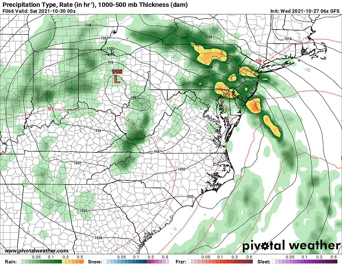
Our next storm system rolls in Friday. It's not quite a nor'easter or coastal storm, although it looks like there will be a coastal component and some ocean enhancement.
The first half of Friday looks OK. There will probably be some showers around, but I think you'll find pockets of dry weather too. It will be mostly cloudy and cool, with highs only reaching the upper 50s.
There is some variation among forecast models regarding the exact start time of the "main event". As early as 2 p.m. Friday afternoon. As late as 10 p.m. Friday evening.
It looks like the peak of this storm system here in New Jersey will come Friday night. Several hours of moderate intensity rain seem likely for everyone. Maybe some heavy stuff. Guidance suggests rainfall totals will only hit an inch or two, at the most. Given our saturated ground and swollen waterways, that could be enough to cause a resurgence of flooding issues. Especially if we get localized downpours or training storm cells.
Meanwhile, the wind field of Friday's storm system looks pretty impressive. My math shows widespread 40+ mph gusts seem through the brunt of the storm. Models are painting just enough instability and shear Friday night to sustain some strong-ish thunderstorm cells embedded in there too.
Coastal flooding could be an issue Friday-Saturday too. Early tidal guidance is suggesting the possibility of exceeding moderate flood stage. Definitely worth watching.
So, another round of unsettled, active, potentially nasty weather. Maybe some weather hazards to be aware of. But it does not look like a blockbuster, head for the hills kind of storm.
Saturday
Spotty rain will probably continue for the first half of Saturday, as Friday's storm system departs. It won't be a washout though.
Otherwise, Saturday will be mostly cloudy and seasonably cool with highs in the lower 60s or so.
Sunday (Halloween) & Beyond
Halloween is one of the most important weather forecasts of the year, for the millions of little trick-or-treaters around New Jersey! I am optimistically keeping Sunday's forecast "bone" dry. Clouds will probably continue to win the sky, But no wind or cold weather issues. High temperatures Sunday afternoon will hit the mid 60s.
Monday might be the nicest day of the next week, as sunshine breaks out and temperatures touch the upper 60s.
The forecast for Election Day Tuesday is mainly dry, with only an isolated shower chance.
Next opportunity for a "bigger" storm would be late next week.
Dan Zarrow is Chief Meteorologist for Townsquare Media New Jersey. Follow him on Facebook or Twitter for the latest forecast and realtime weather updates.
New Jersey's best tourist town for all 4 seasons
9 Dumb Things About New Jersey
More From Beach Radio