NJ weather: 6 things to know about this weekend’s nasty nor’easter
UPDATE... This article is outdated...
For the latest winter storm forecast information, please refer to my newest weather blog post.
UPDATE as of 4:28 p.m. Saturday...
ORIGINAL POST from 9:08 a.m. Saturday...
1.) First of all, it's cold.
We can't really dig into the latest forecast for the big storm without first looking out the window. Bitter cold has returned to New Jersey to start the weekend. Saturday morning minimum temperatures across New Jersey ranged from -2 degrees (Sussex County) to +18 degrees (Cape May County). Factor in the wind, and the wind chill ("feels like" or "apparent" temperature) dipped below zero in many locations.
High temperatures on Saturday will only reach the lower to mid 20s across New Jersey. Yes, we are entering the average coldest part of the year — the "dead of winter". But Saturday is still running 15 to 20 degrees below normal for mid-January. Please bundle the heck up.
A Wind Chill Advisory continues until 10 a.m. Saturday for Sussex County only.
This will be our coldest day since... well, Tuesday. But remember, before then, we hadn't had a day this cold in almost three years (February 1, 2019). The polar vortex machine is fired up, and will continue to spit blasts of cold air in our direction. (Probably through the rest of January, at least.)
Temperatures will moderate a bit on Sunday, into the 30s. (Colder 20s to the northwest, warmer 40s along the south coast.)
These "antecedent" conditions (the "before" picture) will ensure the ground is cold enough for snow to stick immediately upon arrival Sunday night. It also means most (but not all) of New Jersey will see wintry precipitation to start. However, rising temperatures are a very important part of this forecast, so don't expect the chill to last for the duration of our impending nor'easter.
2.) Expect about 12 to 16 hours of nastiness.
Forecast models have been very consistent about how the timeline for this weekend's storm is going to play out.
Initial precipitation (likely snow) will push into southwestern New Jersey starting around 4 p.m. Sunday. By 7 or 8 p.m. all of New Jersey could see something falling from the sky.
Between 8 p.m. and 4 a.m. will be the "brunt" of the storm, with the heaviest bands of snow, wintry mix, and rain progressing from south to north across the state.
Between 4 a.m. and just after daybreak Monday (8 a.m.), the storm should largely taper off. Additional snow showers will be possible through Monday evening, especially around North Jersey.
3.) It will NOT be a 'snow' storm for most of New Jersey.
Latest model guidance suggests the center of low pressure will track right along the Delaware River, on the western edge of NJ. This is not a snowy scenario for the Garden State, as southerly and easterly winds transport (relatively) warm (i.e. above-freezing) air into our atmosphere. Temperatures may spike to 50 degrees briefly in spots — way too warm for snow.
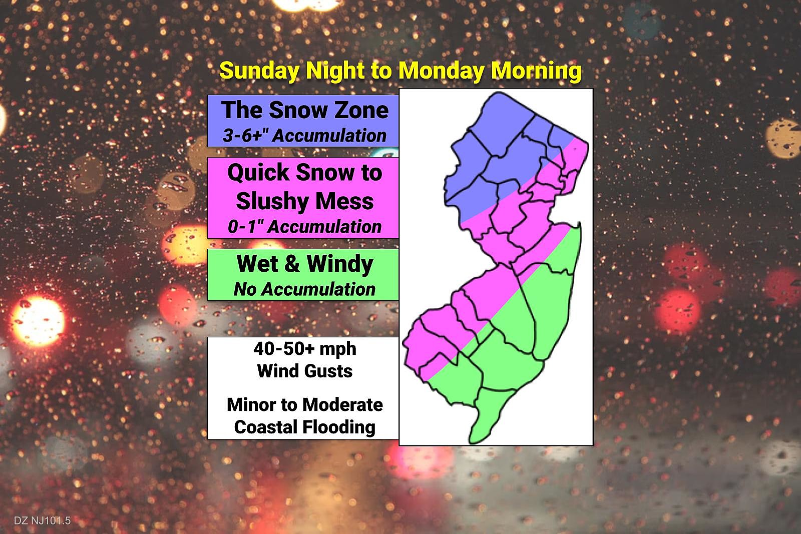
I have tweaked the contours and descriptions on my latest impacts map. But the general idea remains the same as I've promoted previously.
In the "green" zone, I expect little to no snow or sleet to fall. It's just going to be too warm for the duration. Instead, look for upwards of an inch of rain. That rain will be heavy at times, and could cause ponding and flooding on roadways.
The "pink" zone, on either side of the NJ Turnpike, things will get more interesting. A quick burst of snow (lasting perhaps a few hours) will change to a period of wintry mix (snow, sleet, rain) and then soon after just plain rain. The timing of that transition versus the timing of heaviest precipitation will dictate whether anything sticks to the ground at all. I think an inch of slush and perhaps some light icing would be a concern in this area Sunday evening, before we transition to "just plain wet" conditions for Monday morning. It's worth mentioning that this section of the forecast carries the lowest confidence — any little last-minute wiggle in the storm track could ultimately shift expectations either snowier or rainier.
Finally, the "blue" zone of North Jersey will see snow for most of the storm, at least until early Monday morning (about 2 a.m.) I do expect a late-game flip to wintry mix or even straight snow, but it's probably going to happen after the heaviest precipitation bands blow through. Therefore, you'll already have a few inches of snow accumulation on the ground before any transition occurs. I'm holding steady on a 3 to 6 inch forecast here — but please note, models have gone as high as 8 or even 10 inches in a colder all-snow scenario.
A Winter Storm Watch has been issued for Sussex County only, from 6 p.m. Sunday to Noon Monday. The tippity-top of New Jersey has the best chance of seeing 6+ inches of snowfall from this storm.
4.) Don't ignore the wind threat.
As that low pressure center travels up the Delaware River, it is going to be quite strong. The Euro shows it around 986mb, which is akin to a strong tropical storm. (Don't misread me here, it is not a tropical storm — different dynamics, different steering mechanisms, very different impacts.)
Such a strong pressure gradient is conducive to gusty winds. Top easterly gusts of 40-50 mph (inland) and 50-60 mph (coast) will peak early Monday morning. And then another "whoosh" of wind will come late Monday, as high pressure builds in from the west.
Sporadic power outages are possible. Driving may be difficult in big wind gusts, especially in a high-profile vehicle like a truck, bus, or van. In addition, the wind will significantly lower visibility in snow or rain. And just make it feel extra nasty overnight.
5.) Heads up for coastal flooding.
An easterly wind is an on-shore wind, which rings alarm bells for flooding along New Jersey's numerous tidal waterways.
According to the latest tidal guidance, the most vulnerable piece of our coastline here will be the Raritan Bay, up the Arthur Kill to Newark Bay. The strong wind blowing from the east will fill up the bay and not let it drain, potentially leading to "moderate" category flooding.
A Coastal Flood Watch has been issued for areas surrounding the Raritan Bay, including parts of coastal Monmouth, Middlesex, Hudson, Union, and Essex counties, from Sunday night to Monday morning. That will likely become a warning if this forecast holds steady.
Meanwhile, other coastal areas along the Jersey Shore could see some water inundation issues. But only exceeding "minor" flood stage. This is a matter of timing more than anything else. Oceanfront high tide times are around 7 p.m. Sunday and 7 a.m. Monday. Back bays will crest around 10 p.m. Sunday and 10 a.m. Monday. Miraculously, the strongest on-shore winds, blowing during the overnight hours, will occur close to low tide for most of the Shore.
6.) What should you do to prepare for the storm?
Probably nothing. This is not a "bread and milk", "stranded for days", "batten down the hatches" kind of storm. It is going to get nasty for a while. But we're not getting buried.
Sloppy travel conditions are likely Sunday night through early Monday morning. But during an overnight storm, most New Jerseyans and safe and sound in bed. This storm will not coincide with any major rush hour.
Even Monday morning's impacts will be mitigated by the fact that it's a holiday (Martin Luther King Jr. Day). Many schools and business will already be closed, lessening the need for last-minute weather-related closings.
Still, you should carefully consider any travel plans for Sunday evening. Remember the highest chance for wintry weather is at onset, so road conditions could go downhill quickly in that 4 p.m. to 8 p.m. Sunday time frame.
If your Monday plans are especially sensitive to weather or ground conditions, you may want to set your alarm a bit early to check out the situation and allow extra commuting time if needed. (Especially in the "snow zone" of North Jersey.)
This is a powerful, major winter storm. And a swath from North Carolina to New York could see 1 to 2 feet of snow accumulation. We're just on the wrong side of this one, New Jersey. And while there's still time for the forecast to wiggle and evolve, it would take a pretty seismic shift in the forecast for this to become a snow bomb here.
Keep warm, stay smart, and be safe out there. Next weather blog update expected by mid-morning Sunday.
Dan Zarrow is Chief Meteorologist for Townsquare Media New Jersey. Follow him on Facebook or Twitter for the latest forecast and realtime weather updates.
Every Video Game Movie Ever Made, Ranked From Worst to Best
20 VHS Tapes That Are Still Extremely Valuable
More From Beach Radio