Just ‘breezy’ Friday for NJ – watching a potential weekend storm
Looking back at the past two days of wind and rain, our forecast fared quite well. New Jersey's top wind gust was 64 mph at High Point, Sussex County. (With several 50+ mph gusts along the Jersey Shore early Thursday morning too.) Rainfall totals ranged from just shy of an inch along the coast to upwards of 3 inches in northeastern New Jersey (3.36" at West Milford, Passaic County).
Slowly but steadily, our weather will calm down Friday. Wind speeds are down, at least partial sunshine returns, and we'll enjoy dry weather and dry air. The weekend will be about 50/50, based on the track of a potential tropical cyclone.
Temperatures on this Friday morning are mainly in the chilly upper 40s. Friday afternoon will be similar to Thursday, with highs on either side of 60 degrees. (I'd love to warm things up a few more degrees, but the shift to a northwesterly wind will keep temperatures at bay.) Skies will be partly sunny. And let's call the day breezy, with occasional gusts to about 30 mph through at least the first half of Friday.

The wind will finally die down Friday night, becoming nearly calm sometime between sunset and sunrise. The combination of still air, clear skies, and dry conditions will lead to a pretty cold overnight — one of the coldest of the season so far. Low temperatures are forecast to reach the mid 30s to lower 40s.
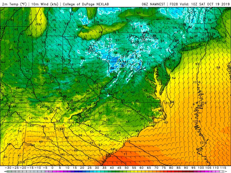
In Northwestern New Jersey, it will probably get cold enough for frost to form. In fact, the National Weather Service has issued a Frost Advisory for western Bergen, Hunterdon, Morris, Passaic, Somerset, Sussex, and Warren counties for early Saturday morning. (Remember, it does not have to reach the freezing point for frost to form — 37° is generally cold enough.) I wouldn't rule out some patchy frost in the middle of the Pine Barrens too, if the wind becomes dead calm.
We kick off the weekend with a nice autumn day. You'll see plenty of sunshine Saturday, with some late clouds building in. High temperatures will be just below seasonal normals, in the lower 60s. (NJ's normals right now are 64 to 66 degrees.)
Sunday, unfortunately, looks not so nice. We're carefully watching the track of Potential Tropical Cyclone #16 which, as of this writing, was developing over the western Gulf of Mexico. This system is expected to strengthen into a tropical storm on Friday — the next name on the list is Nestor.

Likely-tropical-storm-Nestor is expected to make landfall along the Florida panhandle early Saturday, tracking through the southeast U.S. through the weekend. Guidance shows a strong consensus toward the storm ejecting into the Atlantic Ocean from North Carolina late Sunday.
That's definitely close enough to push some clouds into New Jersey on Sunday. And probably close enough to produce some rain. At the moment, I'm not concerned about potentially damaging winds.
There are still significant question marks surrounding the timing and spread of that rain. Depending on which forecast model you believe, Sunday's rain chance ranges from a few showers along the southern coast to steady, heavy-at-times, all-day rain for most of the state. So it's still not a sure bet, but I believe the truth lies somewhere in the middle — mostly cloudy to overcast skies, a period of steady rain possible for southern and coastal New Jersey, and scattered showers stretching through the rest of the state on Sunday.
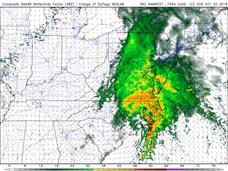
The potential tropical cyclone will make its closest pass to New Jersey Sunday night into early Monday morning, as an extratropical storm. It will be close enough to warrant coastal flooding alarm bells. Tide models are only run 72 hours out, so we're right on the edge of having data. It looks like a foot of storm surge will be enough for minor flooding at high tide on Monday. But I have to stress that forecast is highly dependent on the storm's exact track and wind speed/direction.
The extended forecast currently shows a flip back to sunshine with seasonable temperatures on Monday. Our next cold front will sweep another batch of rain through New Jersey on Tuesday. And then cooler, drier, sunnier conditions should prevail for Wednesday and Thursday.
Dan Zarrow is Chief Meteorologist for Townsquare Media New Jersey. Follow him on Facebook or Twitter for the latest forecast and realtime weather updates.
More From Beach Radio