Jersey Shore Report for Monday, November 18, 2019
Advisories
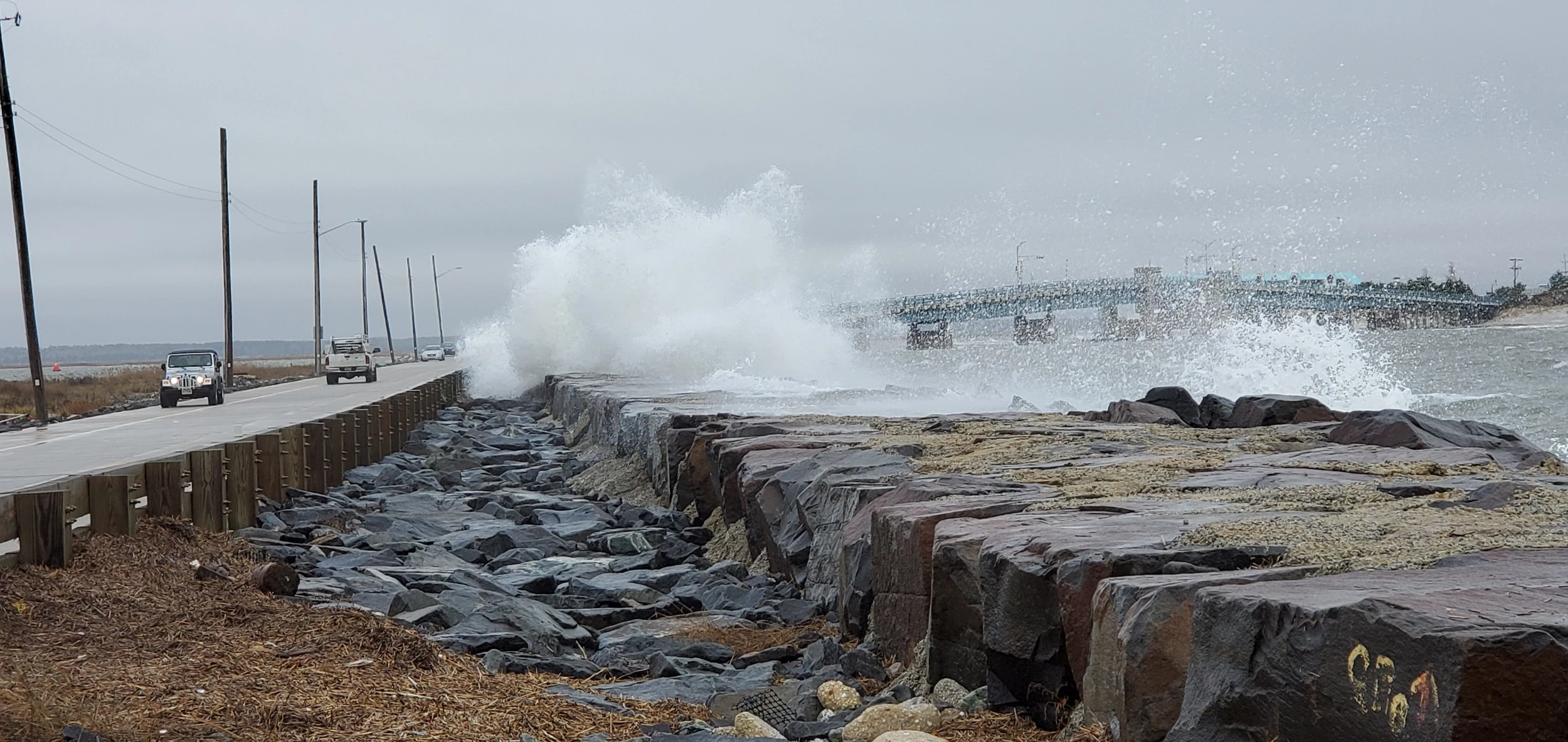
—A Coastal Flood Advisory is in effect until 4 p.m. Sunday for the entire Jersey Shore (Middlesex, Monmouth, Ocean, southeastern Burlington, Atlantic, Cape May, Cumberland, and Salem counties). 1 to 2 feet of storm surge will cause minor to moderate flooding at high tide.
At the Shore
Current conditions and forecast as of Monday morning
| Air Temperature | 43° - 48° |
|---|---|
| Winds | From the North 15 - 28 mph (Gust 36 mph) 13 - 24 knots (Gust 31 knots) |
| Waves | 5 - 11 feet |
| Rip Current Risk | High |
| Ocean Temperature | 47° - 52° (Normal 52° - 53°) |
| Sunrise/Sunset | 6:50am - 4:45pm |
| UV Index | 1 (Low) |
Live from the Shore
Tide Times
| SANDY HOOK Sandy Hook Bay | Low Mon 5:19a | High Mon 11:40a | Low Mon 6:28p | High Tue 12:35a | |
| LONG BRANCH Atlantic Ocean | High Mon 11:14a | Low Mon 5:52p | High Tue 12:09a | Low Tue 5:53a | |
| MANASQUAN INLET Atlantic Ocean | High Mon 11:28a | Low Mon 6:04p | High Tue 12:23a | Low Tue 6:05a | |
| SEASIDE HEIGHTS Atlantic Ocean | High Mon 11:10a | Low Mon 5:56p | High Tue 12:05a | Low Tue 5:57a | |
| SEASIDE PARK Barnegat Bay | Low Mon 9:24a | High Mon 3:20p | Low Mon 10:33p | High Tue 4:15a | |
| BARNEGAT INLET Barnegat Bay | Low Mon 5:17a | High Mon 11:31a | Low Mon 6:35p | High Tue 12:24a | |
| MANAHAWKIN BRIDGE Manahawkin Bay | Low Mon 8:58a | High Mon 2:27p | Low Mon 10:07p | High Tue 3:22a | |
| LITTLE EGG INLET Great Bay | Low Mon 5:51a | High Mon 12:28p | Low Mon 7:06p | High Tue 1:12a | |
| ATLANTIC CITY Atlantic Ocean | High Mon 11:12a | Low Mon 6:02p | High Tue 12:04a | Low Tue 5:57a | |
| OCEAN DRIVE BRIDGE Townsends Inlet | Low Mon 5:17a | High Mon 11:55a | Low Mon 6:29p | High Tue 12:33a | |
| WILDWOOD CREST Atlantic Ocean | Low Mon 5:00a | High Mon 11:26a | Low Mon 6:07p | High Tue 12:06a | |
| CAPE MAY Delaware Bay | Low Mon 5:58a | High Mon 12:30p | Low Mon 6:58p | High Tue 1:09a |
Marine Forecast
From the National Weather Service, Mt. Holly
SMALL CRAFT ADVISORY IN EFFECT THROUGH TUESDAY AFTERNOON
OVERNIGHT: NE winds around 25 kt with gusts up to 30 kt. Seas 8 to 13 ft. Swell mainly from the NE with a dominant period of 12 seconds. Rain likely late this evening. A chance of drizzle with vsby 1 to 3 NM.
MON: N winds 20 to 25 kt with gusts up to 30 kt, diminishing to 15 to 20 kt with gusts up to 25 kt in the afternoon. Seas 9 to 12 ft, subsiding to 7 to 10 ft late. Swell mainly from the E with a dominant period of 12 seconds. A chance of rain in the morning, then rain likely in the afternoon.
MON NIGHT: W winds 10 to 15 kt with gusts up to 20 kt. Seas 7 to 10 ft, subsiding to 5 to 8 ft early in the evening. Swell mainly from the E with a dominant period of 11 seconds. Rain likely, mainly in the evening.
TUE: W winds 10 to 15 kt. Gusts up to 25 kt in the morning, then 20 kt late. Seas 4 to 7 ft, subsiding to 3 to 5 ft early in the afternoon. Swell mainly from the E with a dominant period of 10 seconds. A chance of rain early in the morning.
TUE NIGHT: NW winds around 10 kt with gusts up to 20 kt. Seas 3 to 4 ft.
WED: NW winds 10 to 15 kt, increasing to 15 to 20 kt in the afternoon. Gusts up to 25 kt. Seas 3 to 4 ft.
WED NIGHT: NW winds 15 to 20 kt with gusts up to 25 kt. Seas 3 to 4 ft.
THU: W winds 10 to 15 kt. Gusts up to 20 kt in the morning. Seas around 3 ft in the morning, then 2 ft or less.
THU NIGHT: SW winds 15 to 20 kt with gusts up to 25 kt. Seas 3 to 5 ft. A chance of showers.
FRI: W winds 15 to 20 kt with gusts up to 25 kt. Seas 3 to 5 ft. A chance of showers.
FRI NIGHT: NW winds 15 to 20 kt with gusts up to 30 kt. Seas 4 to 6 ft.
Plan Your Trip
Data on this page amalgamated from several sources, including the National Weather Service (weather), National Ocean Service (tides), U.S. Naval Observatory (sun), and the U.S. Environmental Protection Agency (UV index).
More From Beach Radio