Flash floods possible across all NJ from soaking remnants of Ida
TRENTON – New Jersey is expected to get drenched midweek by the remnants of powerful Hurricane Ida, with the prospect of flooding in areas that get soaked the most – which is still a moving target.
State climatologist David Robinson said north and central New Jersey saw a tremendous amount of rain Aug. 22 and 23 from the remnants of Hurricane Henri, followed by scattered rain ever since throughout the state.
“So, what we call antecedent conditions are quite wet. And that includes the soil, that includes our streams and rivers, which while are subsided greatly from where they were a week ago are still running a little high,” Robinson said.
“That means that any moisture that comes from the remnants of Ida is going to fall on wet ground with ample water within our rivers and streams,” he said. “Thus, it will take less to exacerbate flooding than it did going into Henri, when we had been pretty much on the dry side for a couple of weeks. Humid, but not real rainy.”
It’s still not clear where the heaviest rain will fall, as the storm is expected to hit Wednesday into Thursday. Robinson said northern and central parts of the state got the most rain from Henri, with rainfall totals in the Highlands of 7 to 8 inches, and that forecasts Monday had that area receiving another 3 to 5 inches of rain.
“That would be where the concern would be for the Passaic basin and the Raritan basin, streams that feed into the main stems of those rivers, perhaps even the Delaware River,” Robinson said. “That’s where we’d have our greatest concern as we look to later Wednesday and into Thursday.”
New Jersey 101.5 chief meteorologist Dan Zarrow said it’s a question of when, not if, it’s going to pour and potentially flood. The whole state is under a flash flood watch from Wednesday morning through Thursday evening, a heads-up that potentially dangerous conditions are on the horizon.
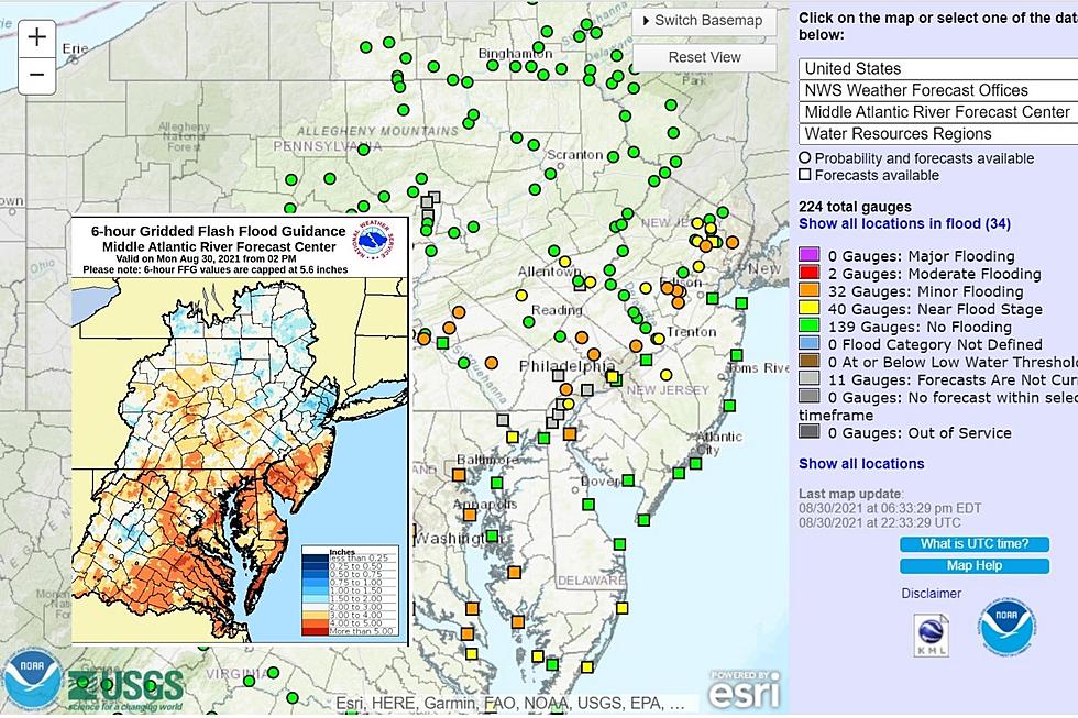
Zarrow pointed to the flash flood guidance from the National Weather Service, which takes into account soil moisture and stream flow.
“In this case, I'm looking at the 6-hour guidance number,” Zarrow said. “As little as an inch of rain would be enough to cause water inundation issues in waterlogged North Jersey. It could take up to 4+ inches for the same to happen in South Jersey, which was mainly spared the drenching from Fred and Henri. That's still enough to potentially flood.”

Robinson said catastrophic flooding isn’t expected but that last week’s flooding – the largest on some rivers in New Jersey in six or seven years – could repeat, depending where the rain is most enhanced, like happened last week in southern Middlesex County.
“Could there be areas of enhanced precipitation like that with this upcoming event? Absolutely. Could we pinpoint them right now? Absolutely not,” Robinson said.
“There is the chance that there could be areas that would pick up 6 to 8 inches of rain in relatively short order,” he said. “That’s not expected to be the biggest issue statewide. But of course, if it hits you locally, it can be devastating.”
Michael Symons is State House bureau chief for New Jersey 101.5. Contact him at michael.symons@townsquaremedia.com.
Remembering Tropical Storm Irene's impact on NJ, 10 years later
DAN ZARROW: NJ's Top 10 Weather Stories of 2020
More From Beach Radio


