Big cooldown arrives Thursday, with heavy rain and strong thunderstorms
The Bottom Line
Happy July 1st! Three days of blazing heat and soupy humidity, featuring a trio of record high temperatures broken at Newark (99, then 102, then 103). One of New Jersey's most ferocious June heat waves finally comes to an end Thursday.
And the heat is going to exit with a bang, as a strong cold front drives in some nasty weather starting Thursday midday. Flooding rain and severe thunderstorms are possible.
Then our attention turns to the 4th of July weekend. Which is going to start wet, unsettled, and (dare I say) rather cool. But the deeper we go into the holiday weekend, the drier, brighter, and more pleasant our weather will get.
Along with giving my usual rundown of the weather timeline and impacts, I'm going to once again include my analysis of fireworks chances for each day too.

Thursday
While the day is starting warm and humid, it definitely will not end the same way.
With temperatures starting in the lower 70s Thursday morning, we do have another shot at 90 degrees in South Jersey. Most of the state will pop into the 80s by late morning. Meanwhile, dew points are ever-so-slightly lower than they have been, so it might feel somewhat less steamy.
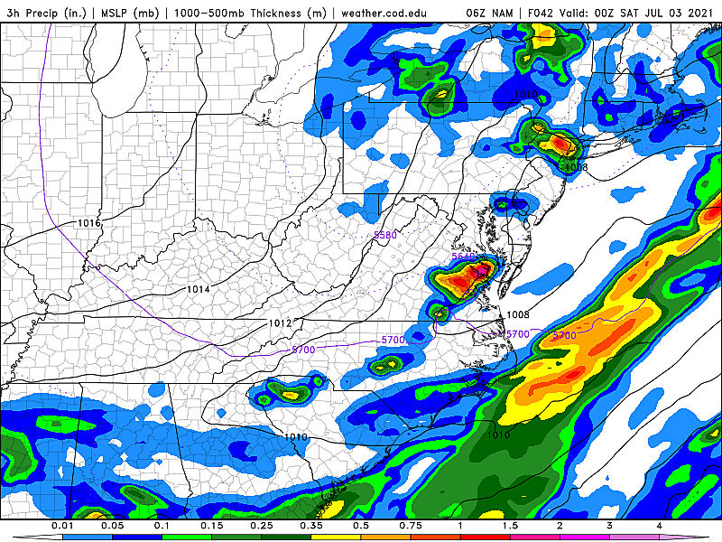
A cold front approaching from the west will drive wet and stormy weather into New Jersey later on. For several days, my forecast has called for rain to arrive around "midday Thursday," and that timeline still generally looks to hold true. First raindrops could fall in NW NJ as early as 10 a.m.
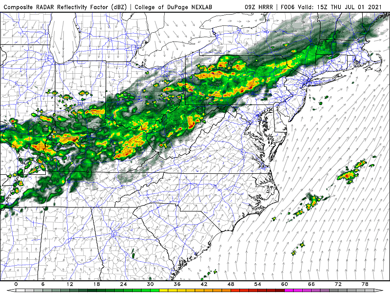
By 2 p.m. the rain will be passed the NJ Turnpike corridor.
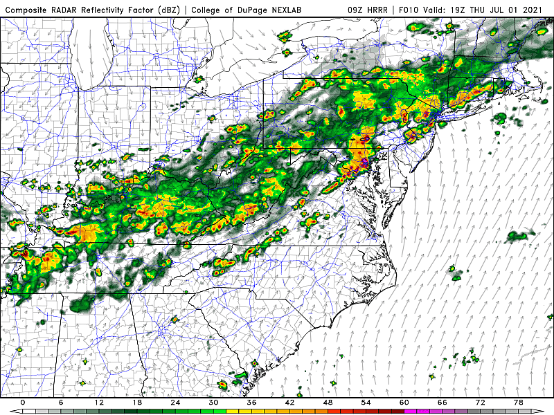
And by 5 p.m. Thursday, it should be raining everywhere in the state.
There are several factors in play that raise alarm bells for this round of rain. The recent heat and humidity have charged the atmosphere. (Although Wednesday night's thunderstorm activity somewhat defused that situation.) This cold front is pretty strong, a sharp gradient between hot and not, providing plenty of lift for storms. And it's also tapped into some tropical moisture, which I believe are the remnants of Tropical Storm Danny.
The bottom line: There will be some pockets of very heavy rain, centered around Thursday afternoon and early evening. Embedded strong thunderstorms may also produce gusty winds and a ton of lightning.
The Storm Prediction Center paints southern New Jersey in a "slight risk" for severe weather Thursday. That geography is simply because that corner of the state will be the hottest - as the atmosphere cooks, there is more convective available potential energy for thunderstorms to feed from. Keep in mind - strong to severe storms are a possibility statewide Thursday.

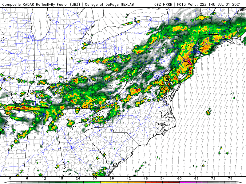
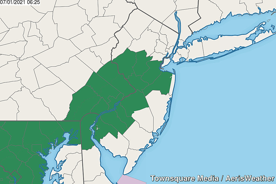
In addition, a Flash Flood Watch has been posted for the heart of the state, in effect from 2 p.m. Thursday through 8 a.m. Friday. This denotes the area most likely to receive over an inch of rainfall. Some models have pumped out much higher rainfall totals - multiple inches, in some cases. If that falls in a short period of time, roadways and low-lying areas will have water issues.
The rain situation should calm down a bit past sunset Thursday evening. But it's still going to be a generally wet and potentially stormy night. Additionally, humidity levels will be slow to fall away - so it will still feel sticky, even with temperatures holding near 70 degrees.
Fireworks Forecast... Any fireworks shows scheduled for Thursday evening will likely need to be cancelled or postponed. Even if you do catch a break in the rain, ground conditions are going to be excessively wet. There may be thunderstorms in the area too, which present a danger to spectators and technicians.
Friday
The heaviest rain will be behind us. And Friday's forecast has been trending drier. But it does still look unsettled and damp at times.
Additional showers and periods of light to moderate rain are possible. Skies will be mostly cloudy to overcast.
But at least the heat wave will be all over! Temperatures will be stuck in the 70s for the majority of the day. If you do catch a break of sun, 80 is a possibility Friday afternoon.
Dew points and humidity levels will dial back a bit Friday night. If we're lucky, temperatures could dip into the comfortably cool 50s for part of NJ by Saturday morning.
Fireworks Forecast... It's going to be iffy. I'm still about 50/50 about whether substantial rain will stick around through Friday evening. It will be a "game-day decision".
Saturday
As the weekend progress, our weather will continue to improve. Having said that, I think we could still see some pockets of rain around on Saturday, as one or two more pieces of energy ride through our atmosphere. There could even be an occasional thunderstorm, putting at least a temporary damper on outdoor activities.
Saturday will also be the coolest day of the week, with high temperatures in the lower 70s at best. Some models even show 60s all day. On the order of 15 to 20 degrees below normal for early July, more typical of a late April or early May day. (Personally, I'm not complaining - it will be a treat after the recent heat and humidity.)
Fireworks Forecast... I'm still thinking chances are good for shooting off fireworks Saturday evening. The chance of lingering rain is low, but not zero.
Sunday
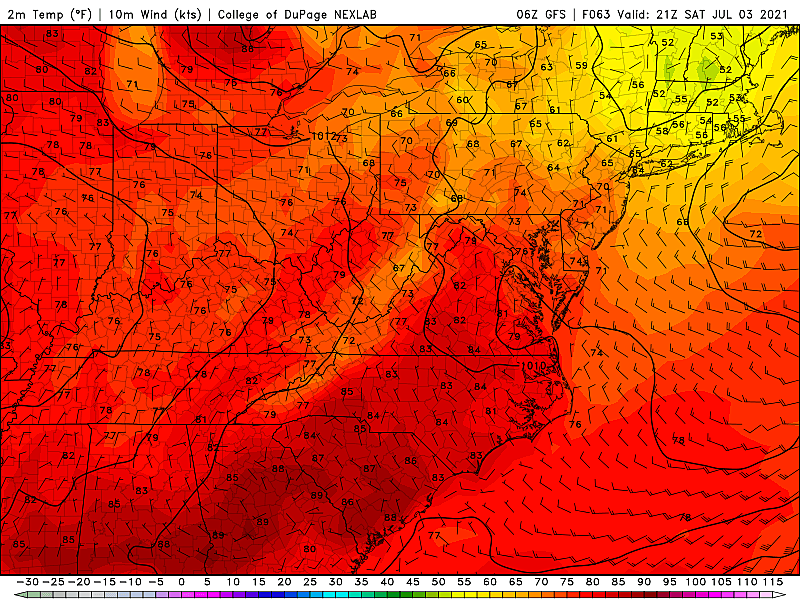
We celebrate America with what I hope will be the nicest day of the weekend. I'm seeing partly sunny skies, high temperatures recovering to around 80 degrees, and manageable humidity (dew points around 60). That's still a bit cooler than normal, but who cares.
There is a slight chance for spot showers on Sunday. But I'm comfortable calling it a mainly dry day.
Fireworks Forecast... Looking good! You'd have to get really unlucky to have a shower overhead Sunday evening.
Monday
The holiday weekend continues on Monday the 5th, which might be the best beach day of the bunch. Temperature return to seasonable (typical) 80s, under partly to mostly sunny skies.
Fireworks Forecast... About the same as Sunday. It should be a pleasant summer evening.
The Extended Forecast
Next week will get hot again, although the latest outlook keeps us out of "the danger zone". Widespread lower 90s are possible away from the coast on Tuesday, with a heat index around the upper 90s.
One important element to watch next week will be the development of Tropical Storm Elsa. As of early Thursday morning, Elsa is way down there in the Atlantic (9 degrees North latitude), currently centered 700 miles east-southeast of Barbados. That puts it about 2,600 miles away from New Jersey at the moment.

The latest forecast track has Elsa entering the Caribbean Sea on Friday, turning northward toward Hispanola, Cuba, and Jamaica by the end of the weekend. Florida could be next - although I will remind you that tropical storm forecasts become highly uncertain after 5 days. While the current outlook calls for Elsa to remain a tropical storm for the duration, I wouldn't be surprised to see our first hurricane of the season (sustained winds > 74 mph).
Elsa's long range forecast could have implications on New Jersey - but again, that would be about 10 days away. Depending on the strength and track of the storm, we could have some enhanced humidity and rough surf. Or perhaps more direct impacts, if Elsa cuts inland through the U.S. or skirts up the East Coast.
As always, it is my job to scan the horizon and denote any storms that are "worth watching," even when far away. If Elsa does pose a real threat to the Garden State and/or the Jersey Shore, I promise you'll be among the first to know. For now, you can just Let It Go.
Dan Zarrow is Chief Meteorologist for Townsquare Media New Jersey. Follow him on Facebook or Twitter for the latest forecast and realtime weather updates.
These Beautiful New Jersey Sunsets Will Take Your Breath Away
More From Beach Radio