

Put the umbrella away, NJ – pleasant, dry weather this weekend
Pop quiz time! Friday is the 28th day of September 2018. Of those 28 days, how many saw rain somewhere in New Jersey?
(Cue the dramatic "think music"...)
The answer is 21. At Newark Airport specifically, all but 7 days of September so far have seen at least a trace of rain. (16 at Trenton, 15 at Atlantic City.) Of course, the alternate story is how torrential some of that rain has been — contributing to ACY's wettest September on record.
Friday is beginning with one final round of soaking rain, before improvements carry us into the weekend.
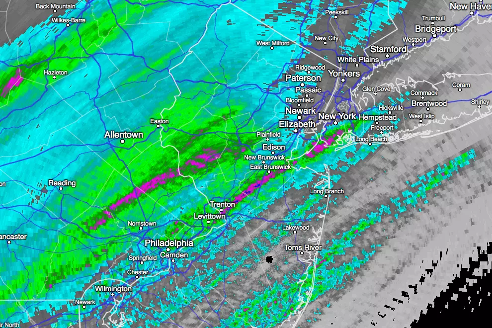
As of this writing (6 a.m. Friday), the sky has been dumping buckets of rain over New Jersey all morning. Top rainfall totals according to radar and weather stations throughout the state are about 1.5". The lowest rainfall totals in the state occurred in far South Jersey, around Cape May and Cumberland counties.
The heaviest rain has already moved off the coast, and the rest of our rain will come to an end by around 9 a.m. Friday. There are significant ponding and flooding issues across the state, so your AM commute might be both rough and tough.
The National Weather Service issued a Flood Warning, Flash Flood Watch, two Flood Advisories, and a Flood Watch for New Jersey. Kind of ridiculous and utterly confusing — so I'm not going to go into the details of each advisory type. Just know that it's wet out there. (Duh.)
It's going to take a little while before our skies substantially dry out and clear. The stiff breeze will die down as the day progresses too. I think you'll see some sunshine by Friday late afternoon. Afternoon temperatures will hover in the upper 60s to around 70 degrees, a hair below normal for late September.
A few clouds will stick around for Friday night, and we could see some fog right along the Jersey Shore. The overnight looks comfortable, although pretty cool. Low temperatures are expected to dip into the lower to mid 50s by Saturday morning.
And then, we dive into the grand finale weekend of September with a simply beautiful weather forecast. I can't decide whether Saturday or Sunday will be the nicer day. Mostly sunny skies, dry weather, and highs in the lower to maybe mid 70s. Awesome.
Just be aware: cool/chilly mornings are going to become the norm as we step deeper into the autumn season. On Saturday morning in particular, there could be some widespread 40s around NW NJ and the Pine Barrens!
Next week doesn't look half bad either, although temperatures will warm into the 80s. We could even come close to 90 degrees by midweek as southwesterly winds kick up — that is obviously way above-normal (but not unheard of) for early October.
More importantly, I don't see any substantial rain in the medium/long-range forecast either. Sure, there will be a few showers around next week (looking at Tuesday and Thursday, specifically). But after an incredibly soggy July-August-September, our umbrellas and windshield wipers deserve a break!
Enjoy the sunshine this weekend!
More From Beach Radio


