NJ weather: Wet, windy, and somewhat wintry start to the weekend
For the second time this week, we are tracking a strong storm system that will affect New Jersey. While the forecast is complicated, with lots of variables and potential impacts to talk about, the headline or bottom line is easy: Our weather turns yucky, raw, and wet Friday night into Saturday, before skies brighten and temperatures cool for Sunday and early next week.

Before the Storm
Friday will be relatively quiet, as the target storm system is centered over western Tennessee and Mississippi. Having said that, we've already had a smattering of sprinkles. And there will be a few waves of spotty showers, as rain chances increase and conditions slowly go downhill into Friday afternoon. Skies will be mostly cloudy to overcast. Temperatures won't be too bad, with 40s in the morning and about 50 degrees for a high.
During the Storm: Timeline
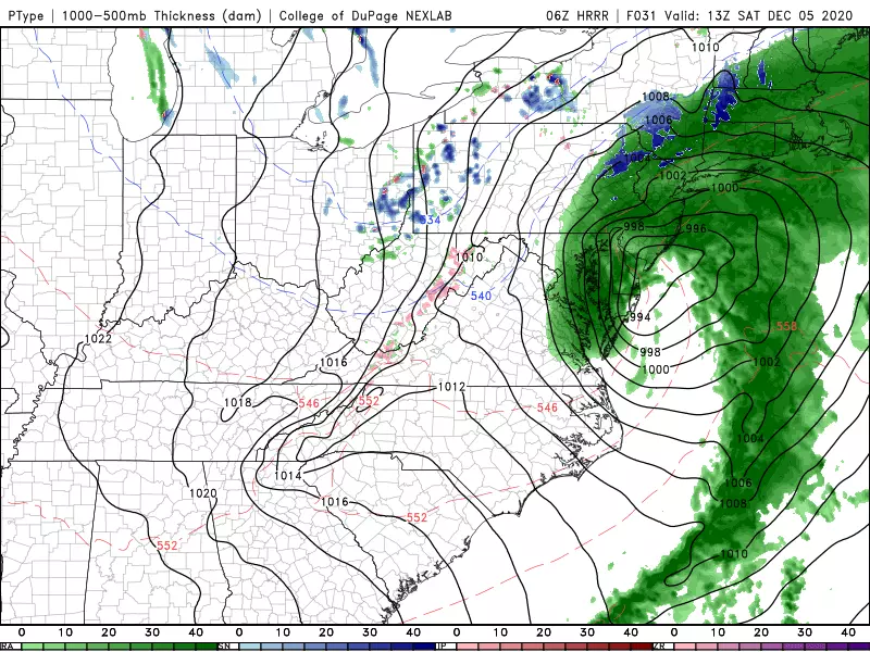
As of the latest model guidance, our storm has been trending 1.) faster, 2.) farther east (off-shore), and 3.) slightly colder. It is going to strengthen dramatically as it exits the coast, leading to a potential "snow bomb" for parts of New England.
I have tweaked our timeline and impacts to match the latest guidance. Here's how I expect things to play out:
—Rain will become steadier and more widespread Friday evening. It's going to feel chilly and raw, as those cold raindrops fall. Overnight lows will dip into the lower 40s.
—The peak of the storm will be Saturday morning. That's when we'll have periods of heavy rain and gusty winds crossing the state.
—Things will taper and calm by Saturday afternoon.
—As temperatures fall through the 40s, there is a chance for some snowflakes anywhere in New Jersey at the tail-end of precipitation. There could even be some light accumulations in far northern New Jersey, in and around Sussex County.
—Skies will clear Saturday evening, leading to much brighter and drier (and cold) conditions for the rest of the weekend.
During the Storm: Impacts
I'd call my forecast confidence here "moderate". I was surprised to see the NAM trend much warmer and drier than it had previously played out. I suspect it's picking up on drier air, a lack of phase between the precipitation and colder air, and a more off-shore track. The GFS and Euro are still holding steady with their "mainly rain and wind, with some snowflakes" solution — and that's where I'm leaning. But I am going to give some wider-than-usual ranges for our storm impacts here, just in case we underperform. (Again, the bottom line of "yucky" weather will hold true, no matter what.)
—Rain... Ranging from 1/2-inch (NW) to 2 inches (SE). Pockets of heavy rain could lead to ponding issues, although the ground should be thirsty enough to soak up the rain, mitigating widespread flash flooding concerns.
—Snow... Snowflakes are possible anywhere in the state as precipitation ends and temperatures drop. However, accumulation will be limited to colder northern Jersey. I think 1 to 2 inches is a reasonable forecast for the higher elevations around Sussex County. (One model was painting over a half-foot of snow accumulation, but I do not buy it.
—Wind... Peaking between 35 mph (north, inland central) and 50 mph (south, coast). Enough to dislodge Christmas decorations and blow your garbage can down the street. Wind-driven rain is nasty stuff.
—Surge... The narrow window of strong northeast winds will present only a limited threat for localized minor coastal flooding. Saturday morning's high tide cycle might run a half-foot to a foot above the base astronomical tide.
—Temperatures... Falling from the upper 40s Saturday morning, to around 40 degrees by sunset Saturday afternoon. We will experience a freeze Saturday night, with lows around 30 — but puddles will probably evaporate and dry out, so I'm not concerned about a widespread "flash freeze" this time around.
After the Storm
By Sunday morning, the storm will be long gone. It will be bright and sunny, but also breezy and cool. High temperatures will only reach about 40 to 45 degrees — that is decidedly below normal for early December.
And 40s is about where we'll stay next week. A few clouds will come into play Monday. As a storm system dives to our south late-day Monday, a snow shower may clip southern New Jersey. (We'll be watching that storm system closely, in case it "wiggles" closer to NJ.)
Partly sunny and lower 40s Tuesday. Mostly sunny and mid 40s Wednesday. Partly sunny and upper 40s Thursday. Next storm system shows up in the long-range models for next weekend.
Be smart, be safe, and be well this weekend. I will almost certainly publish a special weather blog update on our coastal storm system early Saturday morning.
Dan Zarrow is Chief Meteorologist for Townsquare Media New Jersey. Follow him on Facebook or Twitter for the latest forecast and realtime weather updates.
Toms River Storm Damage - 4/21/20
More From Beach Radio