

The ‘Howell Home Depot tornado’ video – a meteorologist’s perspective
Was it a tornado? Was it something else? Was the videographer out of his mind?
UPDATE as of 10:30 p.m. Saturday night...
The National Weather Service has confirmed that a pair of weak tornadoes touched down in Howell Saturday morning. Both were rated EF-0, the lowest of the six levels on the Enhanced Fujita Scale. That equates to maximum winds of 75 mph. NWS estimates the longest-track tornado was on the ground for less than two minutes, over a distance of about a half-mile.
My original unedited analysis appears below, suggesting a tornado in Howell was "probable". Please note that putting your life in danger to shoot such dramatic storm video remains a very, very bad idea.
I spent my day reviewing photos, video, and eyewitness descriptions of Saturday morning's unwelcome severe weather surprise. We brought you live coverage as this wind and rain event unfolded from about 6:30 to 8:30 a.m. And the damage and impacts were quite serious, with numerous downed trees and power outages across central and southern New Jersey.
Undeniably the most compelling piece of media illustrating Saturday morning's thunderstorms was a video taken by Brett M Dzadik of Howell, shared by the Howell Township Police Department on Facebook. Warning: Video contains profanity.
Social media has been buzzing with discussion and debate, attempting to answer one big question: Was there a tornado in that video? Here's my take.
What is a Tornado?
By definition, a tornado is a violently rotating column of air that extends from the base of a thunderstorm cloud to the ground. If it does not meet every single one of these conditions, it is NOT a tornado. If it's not violent, if it's not rotating, if it's not in a thunderstorm, if it's not touching the cloud, and/or if it's not touching the ground? It is NOT a tornado.
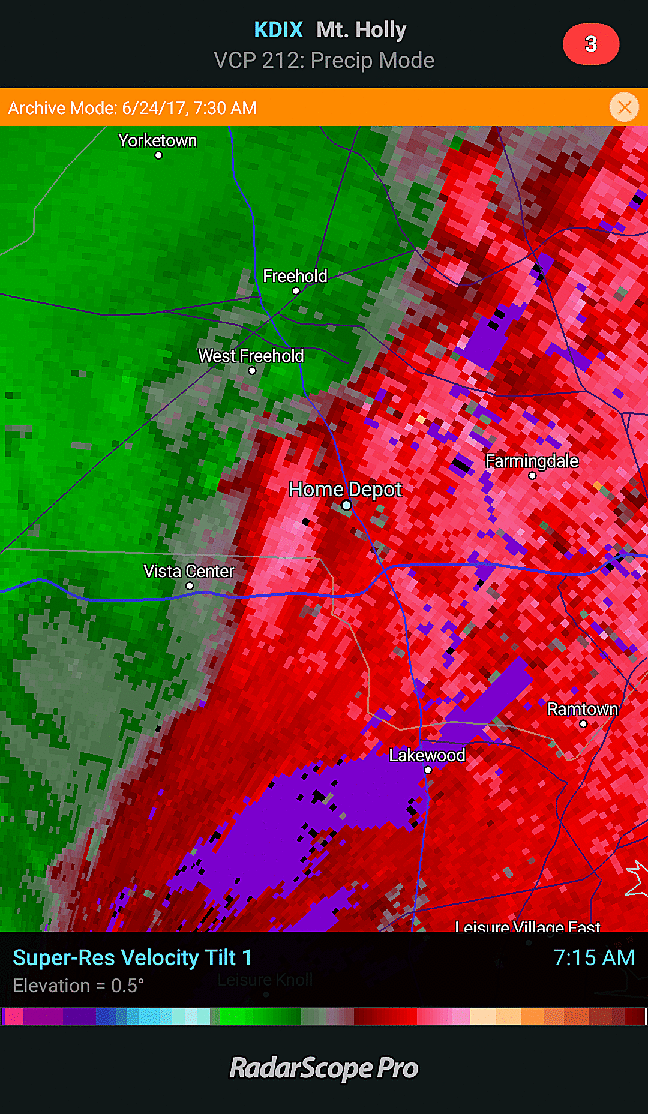
Most of Monmouth County was under a Tornado Warning from 6:39 a.m. to 7:15 a.m. Via radar, I can pinpoint the time of this video as approximately 7:21 a.m. (Yes, after the warning was allowed to expire...)
When forecasting tornadoes using ground-based weather radar, we use the "velocity" product, which color codes particles as red (moving away from the radar) and green (moving toward the radar). Looking for a tornado? Look for bright green next to bright red, indicating an area of tight rotation. The KDIX radar image from 7:21 a.m. does indeed show red next to green. But it doesn't read clear, tight rotation to me.
The Evidence is Compelling
In addition to the obvious — the extreme wind-driven rain throughout — there are two important moments in the video above. The first occurs at the 1:17 mark, where you can make out an ominous shadow in the distance. It sure looks like a rotating funnel. Then, at 1:23, a pair of blue-ish "power flashes" occur in the same vicinity. That's a telltale sign of damaging winds, as a power transformer explodes.
However, we have to be very careful to "officially" call declare it a tornado, until the National Weather Service completes a survey of the damage and all available evidence.
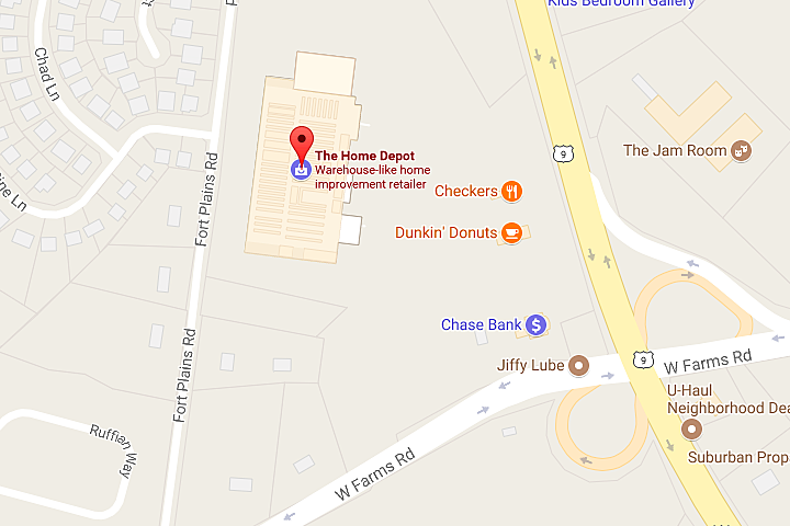
For example, the front entrance of this Home Depot points almost due east. That means the possible tornado, subtly moving left to right in the video, would have been moving from north to south (generally paralleling Route 9). Meanwhile, the line of thunderstorms were moving from west to east. There could certainly be north-south motion embedded in the broader west-east motion. But such orientation does not favor the "yes it was a tornado" camp.
The Bottom Line
I know the video looks pretty "definite," but storm videos like this can be incredibly deceiving. It's a two-dimensional obstructed view of a complicated, turbulent storm. Did we fulfill all the conditions of a tornado? Does the damage pattern show the classic swirl, suggesting a tornadic storm? Maybe.
After watching the video dozens of times, I'd even go so far as to say "Probably." We'll see what the NWS has to say.
The Real Lesson
Whether an official, textbook tornado did or did not touchdown in Howell Saturday morning, there is a MUCH more important issue here that makes my blood boil.
Do you know what you should not do during a tornado or severe thunderstorm? Exactly what this guy did. If flying debris hit that huge window, the cameraman here would have picking glass out of his face for weeks. Or worse.
Hard, fast rule. Tornado warning? Lowest level of a sturdy building, away from windows. Period.
It's always better to play it smart and safe. Not stupid and dead.
More From Beach Radio


