Rainy, windy, cloudy, and cool again Friday for New Jersey
A Flash Flood Watch, Wind Advisory, and Coastal Flood Advisory remain in effect, as the Garden State continues to feel the effects of a strong, stagnant storm system.
UPDATE as of 11 a.m. Friday... The National Hurricane Center has upgraded Matthew to a category 3 "major" hurricane, with impressive maximum sustained winds of 115 mph. It's still spinning through the southern Caribbean Sea, impacting Aruba, Curacao, Venezuela, and Colombia.
It is still way too early to attempt a coherent forecast for the U.S. East Coast / New Jersey. Yes, models are trending eastward, in the out-to-sea direction, through next week. BUT, not a single model even hinted at the explosive intensification Matthew has seen over the past 24 hours (70 to 115 mph). That is a clear sign that NO man or machine has a confident grasp of Matthew's forecast track at this time.
We'll have clearer details in 48 to 72 hours (Sunday or Monday).
ORIGINAL POST from 6:06 a.m. Friday...
The rain that dampened New Jersey on Thursday will continue to do so Friday. And it looks like at least a few showers and plenty of clouds will creep into the weekend too.
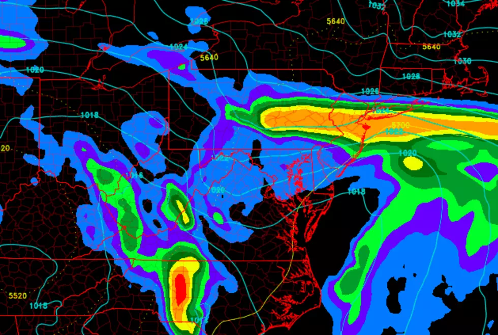
According to the latest information, it looks like the steadiest and/or heaviest rain of Friday will occur during the morning and midday hours. I've seen some forecasts promoting 2, 4, or even 6 inches in South Jersey on Friday. That's ridiculous - the heaviest rain is behaving as expected, staying southwest of NJ. We're looking at another inch or maybe two through the rest of this storm system.
Meanwhile, gusty winds are expected once again for at least the first half of Friday. Gusts to 45 mph will be possible along the coast, with gusts to 35 mph are possible further inland. Temperatures will go nowhere fast due to the rain, clouds, and wind, with highs only in the lower to mid 60s.
Not only will the wind make the day blustery, but it's kicking up some rough surf too. 1 to 2 feet of surge could cause minor coastal flooding at the time of high tide on Friday. 5 foot waves are expected to come off the ocean.
By Friday afternoon, I think we'll see a noticeable reduction in the spread and intensity of rain. A few showers are expected to push through the Garden State Friday night, with a continuing brisk wind (occasionally over 20 mph).
On Saturday, we have to leave scattered showers in the forecast. That means the rain will be "on and off," and I wouldn't be surprised if part of New Jersey stays dry through the daytime hours. Having said that, it's still going to be a "blah" day overall, with damp conditions, cloudy skies, and a continuing stiff breeze. High temperatures should recover a bit to the upper 60s to lower 70s.
We'll continue to dry out Sunday, but showers and sprinkles will remain possible. I remain hopeful that skies will become partly sunny by Sunday afternoon. Even a little peek of sunshine would help push high temperatures back into the pleasant lower to mid 70s.
In the tropics, Hurricane Matthew intensified significantly overnight. As of 5 a.m. Friday, the National Hurricane Center reports the storm has maximum sustained winds of 100 mph, moving due west through the Caribbean Sea. On Thursday, I discussed why New Jersey shouldn't freak out about Matthew, and high forecast uncertainty remains. I'm still waiting until the storm makes a "sharp right turn" to the north this weekend before going into details. But I will say this morning's forecast models are much friendlier toward New Jersey, as the storm track trends in the eastward, out-to-sea direction. Stay tuned...
More From Beach Radio