Heavy rain exits NJ, slow recovery through Saturday afternoon
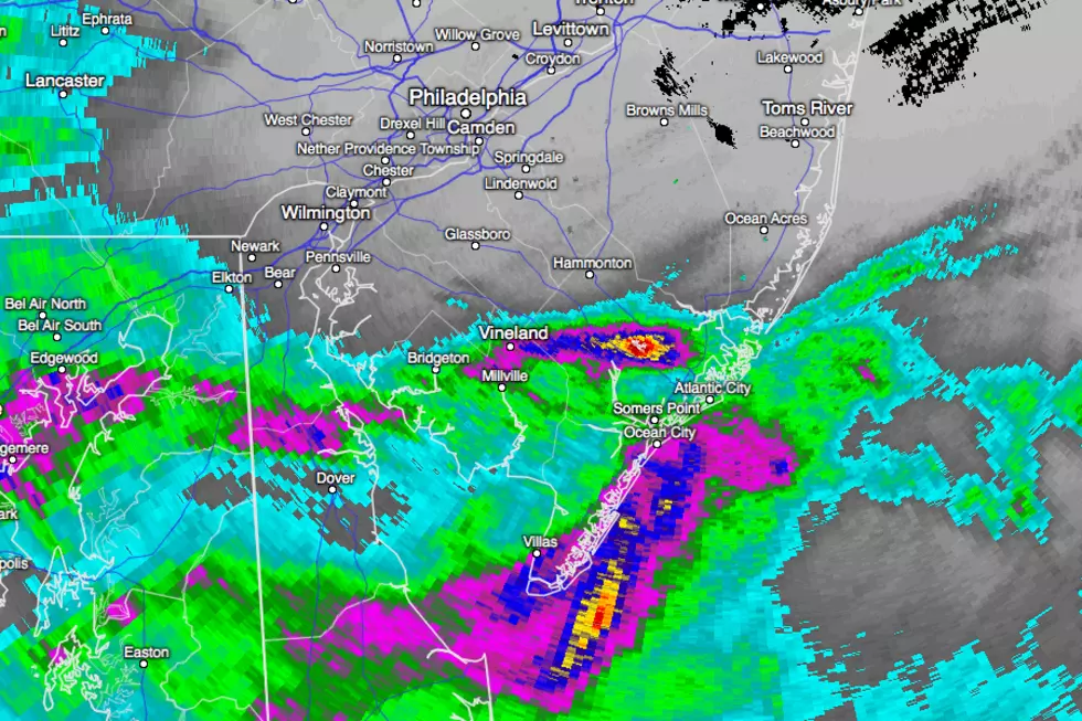
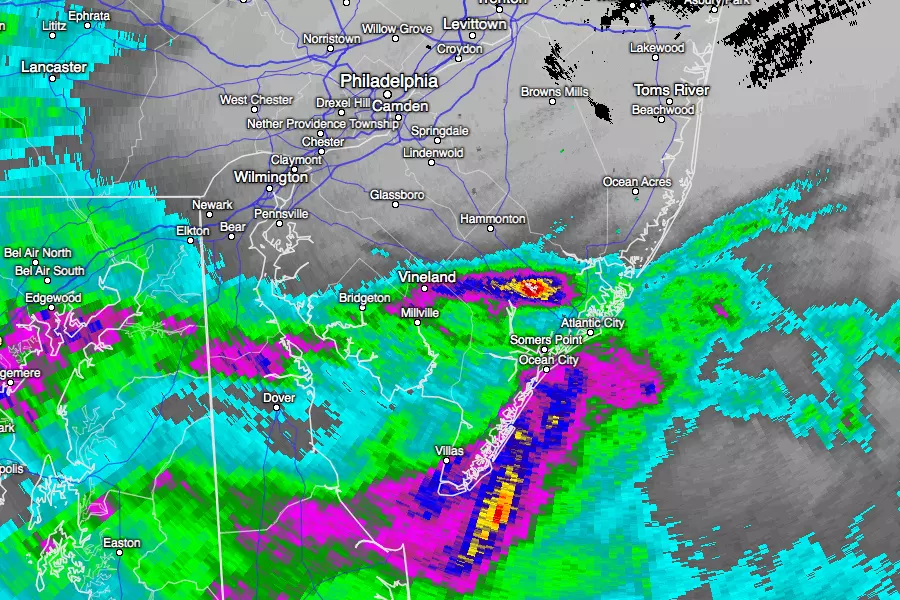
Parts of South Jersey received over 4 inches of rain from late Friday night through early Saturday morning.
The monsoon is just about done. Even though the track of our coastal storm system "wiggled" to the south a bit, rainfall estimates across South Jersey were right on target in the 2 to 4 inch range. A swath of Atlantic and Cape May County even saw 6+ inches overnight — that's a lot of rain!
Meanwhile, the northern half of the Garden State saw hardly any rain at all. Remember that "flop" scenario I've discussed over the past few days? As expected, that's what played out north of I-195, and especially north of I-78.
A Flash Flood Warning is in effect until 8:15 a.m. for southern Cape May County. A less-severe Flood Advisory has been issued for Atlantic, Burlington, SE Cape May, SE Cumberland, and SE Ocean counties until 8 a.m. Saturday. And our cautionary Flash Flood Watch is currently slated to continue until 2 p.m. for Atlantic, Burlington, Camden, Cape May, Cumberland, Gloucester, Ocean, and Salem counties.
Be aware of areas of flooding throughout Saturday where the heaviest rain fell, and use extreme caution and discretion. Never attempt to drive, walk, or swim through flooded areas — the power of water is incredibly dangerous.
As of this writing (around 6 a.m. Saturday), it's still raining at a steady clip across much of Ocean, Atlantic, and Cape May counties. It's windy, it's humid, it's cool, and it's cloudy. Conditions will improve through the rest of Saturday. And Sunday is still looking much better.
Here's a rundown of what to expect through the rest of the weekend:
--RAIN: Most of the "steady" rain will exit the Jersey Shore by mid-morning. Lingering showers will be possible statewide until early afternoon. Raindrops may hang over the southern third to half of New Jersey through Saturday evening.
--CLOUDS:The thick clouds will start to break apart across northern and central New Jersey starting this afternoon. (Yes, we'll probably see some sunshine!) South Jersey (the area where it really poured) will probably be stuck under overcast to mostly cloudy skies all day.
--WIND: The annoyingly brisk wind will continue for most of the day. Inland, sustained winds of 10 to 20 mph with gusts to 30 mph are expected. Closer to the coast, sustained winds up to 30 mph with gusts to 35 or 40 mph are possible. Models suggest the wind will die down substantially Saturday evening, as our storm system continues to chug out to sea.
--TEMPS: The "wet zone" of South Jersey will stay quite cool Saturday, with high temperatures only around 70 degrees. If the northern half of the state does indeed get peeks of sunshine, thermometers could climb as high as 80 degrees.
--COAST: I'm seeing about a foot of extra surge at the oceanfront tide gauges at Cape May, Atlantic City, and Sandy Hook. While nothing to write home about, minor flooding is possible along tidal waterways at the times of high tide. Looks like the most precarious high tide cycle will be Saturday night, just after midnight. A high risk for rip currents is predicted along the Jersey Shore on Saturday — obviously it's not a beach day.
--SUNDAY: It's difficult to control my optimistic excitement, but Sunday really has the potential to become a "spectacular" day across New Jersey. While I still can't rule out a shower and some clouds (especially south), I think sunshine is going to win the sky. Lighter winds will accompany warmer temperatures, in the upper 70s to near 80 degrees.
More From Beach Radio