
Dreaming of a White Christmas? Here’s the latest forecast
Yes, there is a storm system in the forecast for the Garden State on Christmas Day. But will it produce *white* or *wet* weather?
'Twas the week before Christmas
And all through the state,
New Jerseyans were rejoicing
This week's forecast looks great!
But what about Christmas,
Could it be white or wet?
Still seven days away,
We don't know just yet.
It certainly looks interesting,
Better chance than the norm.
Will it be cold enough
For snow to fall from the storm?
I think I'll stop rhyming now,
The novelty has passed.
You want New Jersey weather?
Let's get to the forecast...
By the Numbers
My official statement on the ever-popular White Christmas question... I believe this year could be New Jersey's best shot at snow on Christmas in a while.
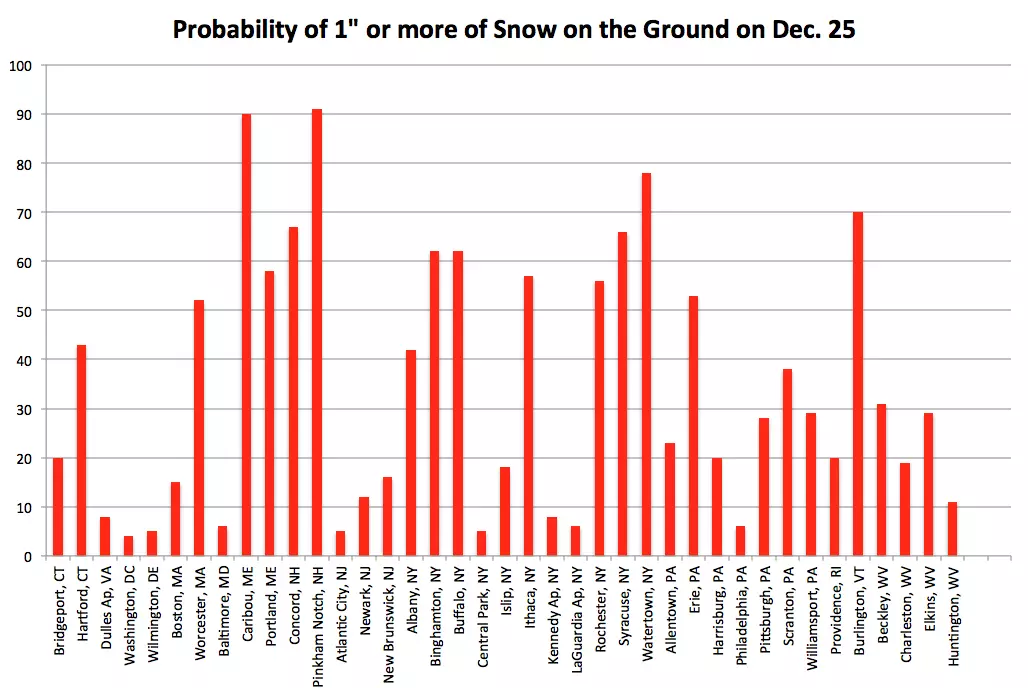
How long has it been since a Jersey Christmas was white? It's a difficult question to answer, and depends largely on your definition and your location. The most traditional definition of a white Christmas requires at least one inch of snow on the ground, on either Christmas Eve or Christmas Day.
By that rule, 2012 was white for part of the Garden State, with an inch of snow reported at the New Brunswick weather station on December 25th.
The last time we saw a widespread (i.e. the whole state) white Christmas? 2009, eight years ago, when about a half-foot of snow lay on the ground across New Jersey. That's the stat I'm going with.
According to the Northeast Regional Climate Center, our historical probability of a White Christmas here in New Jersey ranges from about 5% for South Jersey, to around 15% for North Jersey. In other words, ranging from a 1-in-6 chance to a 1-in-20 chance. Given that our last snowy yuletide holiday was eight years ago, we're right in line with climatological expectations.
The Current Forecast
So far, December has been an unusually cold and snowy month, headlined by a trio of snowstorms (1, 2, 3) in the span of just six days.
That cold air is particularly important to the Christmas forecast. The ground is cold. The roads are cold. That means snowfall is generally more conducive to "stick" and accumulate immediately upon onset, just like we saw during last Friday's awful evening rush hour. Even brief warmups won't change road and soil temperatures much.
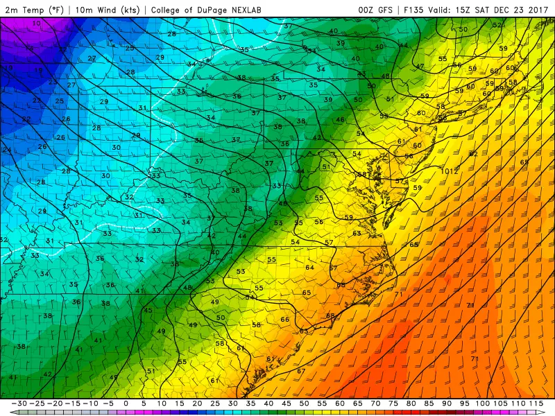
Medium-range models have two storm systems of note on the horizon. The first is forecast to pass through New Jersey from late Friday night through Saturday afternoon. Confidence is reasonably good that this system will carry much warmer air into the Garden State — we're talking temperatures in the 60s on Saturday! So this one would bring all rain. Steady to heavy rain would not be a great scenario for one of the busiest travel and shopping days of the entire calendar, but it could be worse (read: wintry).
Christmas Eve (Sunday) looks quiet. A good day to go over the river and through the woods.
And then along comes Christmas. Both the GFS and European models show a storm system in our neck of the woods sometime between late Sunday (Christmas Eve) and late Monday (Christmas Day). (Note: the GFS shows a much more sizable storm system and more prolonged period of precipitation, as of the latest run.)
So, snow ingredient #1 — a storm system — is there. What about snow ingredient #2, "cold enough" air? Eh, that's a little unclear.
The GFS in particular paints a messy setup for Christmas morning, with swinging temperatures causing a transition from rain to snow to rain. Both models severely limit snow accumulation, and might may not hit that golden 1-inch accumulation to qualify as an officially "white" Christmas. In fact, I'd argue we're just as likely to see a "wet" Christmas, rather than a "white" one.
It's a close call. And one that we'll obviously be tracking closely and talking about regularly as this pre-Christmas week rolls along.
Reasons to Pause
--Uncertainty: As always, we need to ingest an extended forecast with a very large grain of salt. (Make that road salt.) A lot can change over the next 7 days: the anticipated storm system can slow down or speed up; it can wiggle north or south or east or west; it can completely disappear. The temperature profile may be vastly different than what is currently forecast, thereby drastically changing the expected weather impacts. You can get excited about the prospect, if you want — but please keep those expectations in check.
--Travel Issues: The treetops may glisten, and children may listen to sleigh bells in the snow. But Irving Berlin must have stayed home for the holidays when he wrote the song. (At the very least, I doubt he had to endure a white-knuckle drive down Route 9 during rush hour in a snowstorm...) Any significant snow or rain would obviously cause massive headaches and snarl travel by road, rail, and air. Timing of any snow and ice accumulations will be crucial — for now, it would be a very good idea to keep your holiday travel plans as flexible as possible.
Our newsroom has received a statement from the North Pole, confirming that Rudolph is prepared to lead Santa's sleigh in case of inclement weather. We'll keep you posted on the latest developments.
More From Beach Radio


